Blue Ridge
-
Posts
1,598 -
Joined
-
Last visited
Content Type
Profiles
Blogs
Forums
American Weather
Media Demo
Store
Gallery
Everything posted by Blue Ridge
-

Oak Moon Upslope/ Upper Low Storm Obs
Blue Ridge replied to Holston_River_Rambler's topic in Tennessee Valley
O_o- 300 replies
-
- 3
-

-

-
- upslope snow
- upper level disturbance
- (and 3 more)
-
Oak Moon Upslope/ Upper Low Storm Obs
Blue Ridge replied to Holston_River_Rambler's topic in Tennessee Valley
Nothing on cams yet.- 300 replies
-
- 1
-

-
- upslope snow
- upper level disturbance
- (and 3 more)
-
Oak Moon Upslope/ Upper Low Storm Obs
Blue Ridge replied to Holston_River_Rambler's topic in Tennessee Valley
Snow/graupel mix at 35°- 300 replies
-
- 4
-
-
- upslope snow
- upper level disturbance
- (and 3 more)
-
Oak Moon Upslope/ Upper Low Storm Obs
Blue Ridge replied to Holston_River_Rambler's topic in Tennessee Valley
Good stuff! Looks like a nice little pulse rotating through now. PWS per Wunderground shows temps around 35°-36° around the 2500’ elevation mark. Any idea what elevation you are? Keep us updated! . -
Oak Moon Upslope/ Upper Low Storm Obs
Blue Ridge replied to Holston_River_Rambler's topic in Tennessee Valley
48 to 42 in two hours here in Jboro with absolutely wicked wind.- 300 replies
-
- 1
-
-
- upslope snow
- upper level disturbance
- (and 3 more)
-
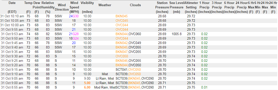
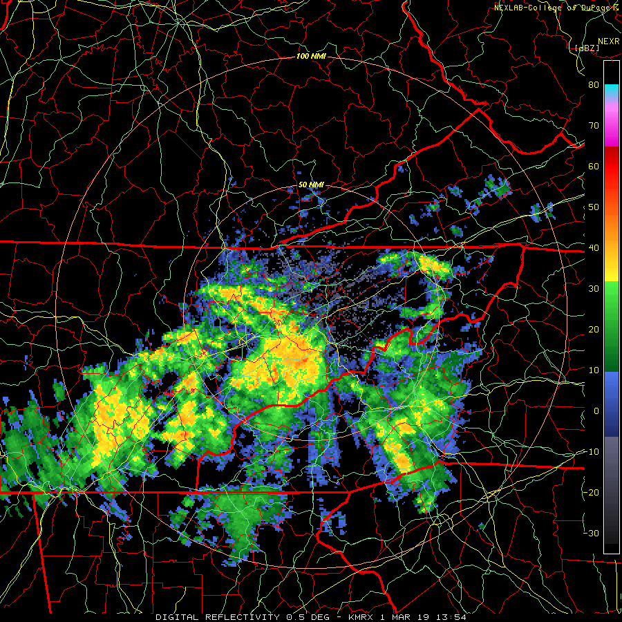
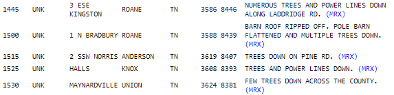
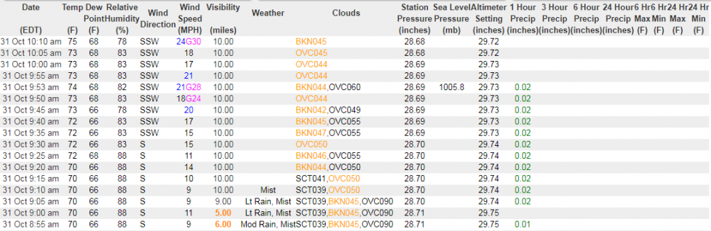
The first wave strengthened as it moved north and east, bringing quite a bit of lightning to the Tri-Cities. We had roughly five minutes of absolutely torrential rain with a breeze that sent sheets onto the window. It sounded for all the world like someone spraying the window with a garden hose from a few feet away. As for the second wave which featured the line responsible for the warning around Knoxville, I saw velocities as high as 84 MPH depicted just prior to the warning's issuance. KMRX's beam height is roughly 2500-3000 ft at that point, so there was likely no ground truth. That said... 0100 AM NON-TSTM WND GST 4.3 W GATLINBURG 35.72N 83.57W 12/30/2019 M84 MPH SEVIER TN MESONET COVE MOUNTAIN OBSERVATION SITE RECORDED AN 84 MPH GUST. THE HIGHEST SUSTAINED WIND WAS 34 MPH.
-
Tornado on the ground in southern MS: The National Weather Service in Jackson has issued a * Tornado Warning for... Southern Lincoln County in south central Mississippi... Southeastern Franklin County in southwestern Mississippi... * Until 345 PM CST. * At 250 PM CST, a confirmed tornado was located near Smithdale, or 8 miles north of Liberty, moving northeast at 35 mph. HAZARD...Damaging tornado and half dollar size hail. SOURCE...Radar confirmed tornado. IMPACT...Flying debris will be dangerous to those caught without shelter. Mobile homes will be damaged or destroyed. Damage to roofs, windows, and vehicles will occur. Tree damage is likely. * This tornadic storm will be near... Little Springs around 305 PM CST. Center Point around 310 PM CST. West Lincoln around 325 PM CST. Bogue Chitto around 330 PM CST. Enterprise around 335 PM CST. PRECAUTIONARY/PREPAREDNESS ACTIONS... To repeat, a tornado is on the ground. TAKE COVER NOW! Move to a basement or an interior room on the lowest floor of a sturdy building. Avoid windows. If you are outdoors, in a mobile home, or in a vehicle, move to the closest substantial shelter and protect yourself from flying debris.
-
Tornado Watch #685 is now in effect for Carter, Johnson, Sullivan, Unicoi, and Washington counties in TN as well as all of Southwest VA excluding Lee Co.
-
The National Weather Service in Morristown has issued a * Tornado Warning for... Eastern Claiborne County in east Tennessee... Northwestern Hancock County in east Tennessee... Lee County in southwestern Virginia... West central Scott County in southwestern Virginia... * Until 1230 PM EDT. * At 1150 AM EDT, a severe thunderstorm capable of producing a tornado was located over Tazewell, or 13 miles southeast of Middlesboro, moving northeast at 65 mph. HAZARD...Tornado. SOURCE...Radar indicated rotation. IMPACT...Flying debris will be dangerous to those caught without shelter. Mobile homes will be damaged or destroyed. Damage to roofs, windows, and vehicles will occur. Tree damage is likely. * This dangerous storm will be near... Jonesville around 1220 PM EDT. Pennington Gap around 1225 PM EDT. The National Weather Service in Morristown has issued a * Tornado Warning for... Eastern Claiborne County in east Tennessee... Northwestern Hancock County in east Tennessee... Lee County in southwestern Virginia... West central Scott County in southwestern Virginia... * Until 1230 PM EDT. * At 1150 AM EDT, a severe thunderstorm capable of producing a tornado was located over Tazewell, or 13 miles southeast of Middlesboro, moving northeast at 65 mph. HAZARD...Tornado. SOURCE...Radar indicated rotation. IMPACT...Flying debris will be dangerous to those caught without shelter. Mobile homes will be damaged or destroyed. Damage to roofs, windows, and vehicles will occur. Tree damage is likely. * This dangerous storm will be near... Jonesville around 1220 PM EDT. Pennington Gap around 1225 PM EDT.
-
Several reports thus far:
-
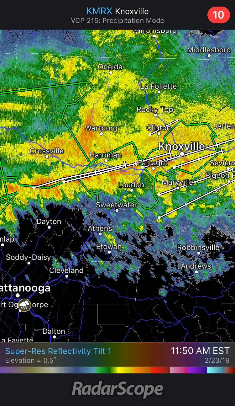
New warning for Knoxville: The National Weather Service in Morristown has issued a * Severe Thunderstorm Warning for... Northeastern Knox County in east Tennessee... Northwestern Jefferson County in east Tennessee... Southwestern Grainger County in east Tennessee... * Until noon EDT. * At 1124 AM EDT, a severe thunderstorm was located over Knoxville, moving northeast at 60 mph. HAZARD...60 mph wind gusts. SOURCE...Radar indicated.
-
The National Weather Service in Morristown has issued a * Severe Thunderstorm Warning for... Northwestern Knox County in east Tennessee... Anderson County in east Tennessee... Southeastern Campbell County in east Tennessee... Union County in east Tennessee... * Until 1145 AM EDT. * At 1057 AM EDT, a severe thunderstorm was located near Clinton, moving northeast at 55 mph. HAZARD...60 mph wind gusts. SOURCE...Radar indicated.
-
2019 is going to continue doing 2019 things, so it stands to reason this winds up a nothingburger. That said, it's fun to track what may well be the last severe threat of the year for the fer east valley. Some clearing is now visible on GOES East; meanwhile, winds have really cranked up at TYS.
-
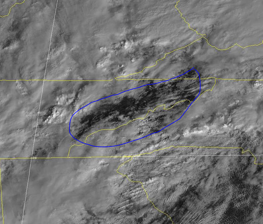
SPC expanded the ENH risk southwestward across the far, far northeastern tip of Johnson County. Upper East TN is in 5% TOR. Any severe weather today will be a matter of threading the needle. MRX sees the LLJ ramping up as a primary catalyst, assuming downsloping does its job and warms the area ahead of the area of showers to the west. The best chance appears to be after this current lobe of moderate rain moves out and the dry area currently north and east of Chattanooga envelops the area. This may allow for warming and an increase in instability.

-
...THERE IS AN ENHANCED RISK OF SEVERE THUNDERSTORMS FROM PORTIONS OF SOUTHERN PENNSYLVANIA SOUTHWARD INTO NORTHERN NORTH CAROLINA... ...SUMMARY... Severe thunderstorms capable of strong wind gusts are expected across much of the eastern U.S. Thursday -- particularly from areas along and east of the central and southern Appalachians to the mid Atlantic and Carolinas coastal areas. ...Synopsis... An upper trough crossing the central U.S. at the start of the period will evolve into a deepening closed low with time, as the system shifts quickly east-northeastward across the Midwest, and then into the Northeast overnight. As this occurs, the broader trough surrounding the low will gradually take on a more neutral to slightly negative tilt, through the end of the period. As this occurs, a cold front -- initially trailing from a low near the KY vicinity southward across Alabama to near the mouth of the Mississippi River -- will advance steadily eastward during the day. The front should cross the Appalachian crest by afternoon, as the parent low rapidly deepens and eventually occludes over the Lower Great Lakes area, reaching the Atlantic coast after midnight. This front will focus a band of showers and thunderstorms -- and attendant risk for severe weather primarily along and east of the mountains. ...Portions of the PA/NY vicinity southward/southwestward to the southern Appalachians... A zone of showers and thunderstorms should be ongoing at the start of the period from the mid Ohio Valley/Mid South region south-southwestward to the western Gulf of Mexico, in the vicinity of an advancing surface cold front. A secondary area of showers -- perhaps with some embedded lightning -- will be shifting quickly northeastward across the Carolinas/Virginia vicinity. Only minimal severe risk -- mainly in the form of gusty winds or a brief tornado -- is apparent at this time within either of these areas of convection through the first several hours of the period. With time, the advance of the cold front across the southern, and then the central, Appalachians during the afternoon in conjunction with the strengthening upper system will result in gradual organization of a band of frontal convection. Very strong flow aloft will aid in the convective organization, with upscale evolution toward a semi-continuous band of storms expected. By late afternoon/early evening, storms will likely have become fairly well-organized, crossing south-central and southeastern PA, MD, VA, and the Carolinas along with attendant risk for strong/damaging wind gusts. Low-level wind profiles will become supportive of supercells during the afternoon across the pre-frontal warm sector. While suggestive of some tornado potential, pre-frontal warm-sector storms are largely not anticipated. Still, a few mainly QLCS-type tornadoes will be possible, given the overall dynamic/kinematic set-up -- particularly from late afternoon through mid evening. As storms near the coast overnight, gradual weakening of the convection -- and associated diminishing of the severe risk -- is expected, though limited wind risk will likely extend to near the mid Atlantic/Carolina coasts overnight. ...MAXIMUM RISK BY HAZARD... Tornado: 5% - Slight Wind: 30% - Enhanced Hail: 5% - Marginal
-
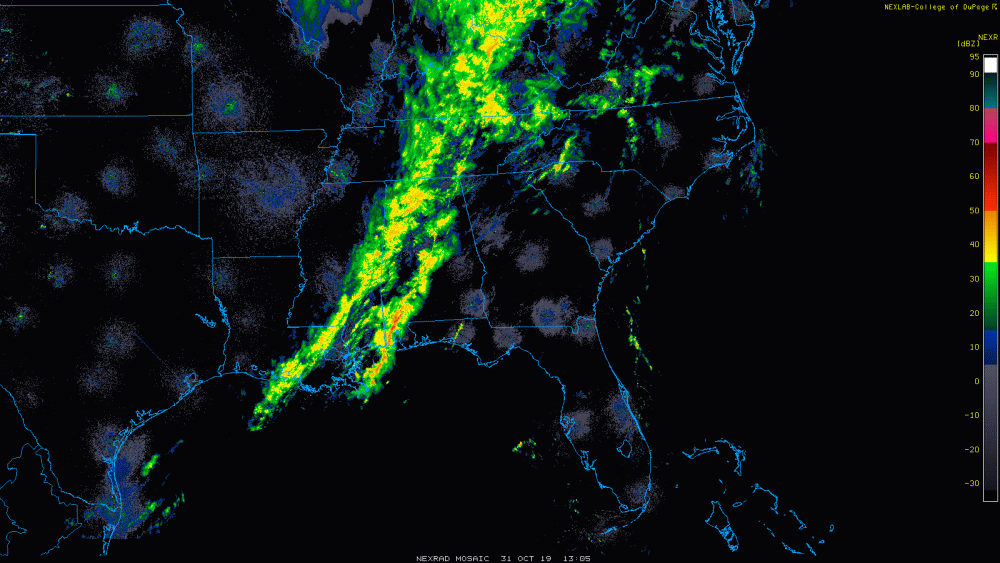
Breezing through the 12z runs, some of the short-range/hi-res models look pretty interesting across the Appalachian Highlands. I'll leave the analysis to the experts, but the supercell composite and STP in particular caught my eye. Seems like most/all are in agreement on a somewhat potent squall line racing through tomorrow evening; whether discreet cells can form ahead of the line is another story. Eagerly awaiting the 1730 SPC Day 2 update.
-
Looks like the nasty cell that flared up between Newport and Parrottsville verified its SVR. MRX received a report of 1.5" hail in Greene County.
-
TN valley heavy rain/flooding week of whenever
Blue Ridge replied to janetjanet998's topic in Tennessee Valley
It's lol-worthy at this point.
-
TN valley heavy rain/flooding week of whenever
Blue Ridge replied to janetjanet998's topic in Tennessee Valley
That's...not good. -
Yeah, no. Doesn’t work like that, buddy. I experienced the same issue as @Windspeed. A similar issue was previously noted on AmWx some time ago. Sometimes it’s the result of malicious script injected w/o the webmaster’s knowledge; other times, an ad can be the culprit. Perhaps don’t be quite so abrasive in the future.
-
TN valley heavy rain/flooding week of whenever
Blue Ridge replied to janetjanet998's topic in Tennessee Valley
Darwinism at work... In other news, we took a long drive around rural Washington and Greene Counties. Limestone Creek is doing a number on north and west sections of Washington Co. I’ll post pics in a bit. -
TN valley heavy rain/flooding week of whenever
Blue Ridge replied to janetjanet998's topic in Tennessee Valley
Noticed the same thing earlier wrt FFWs. In fact, Knox Co does not show a FFW despite the PDS Warning in place. -
TN valley heavy rain/flooding week of whenever
Blue Ridge replied to janetjanet998's topic in Tennessee Valley
If anything, this may have just a bit of wiggle room to move slightly north and still train directly over Knoxville proper. TYS is going to be oh so close. -
TN valley heavy rain/flooding week of whenever
Blue Ridge replied to janetjanet998's topic in Tennessee Valley
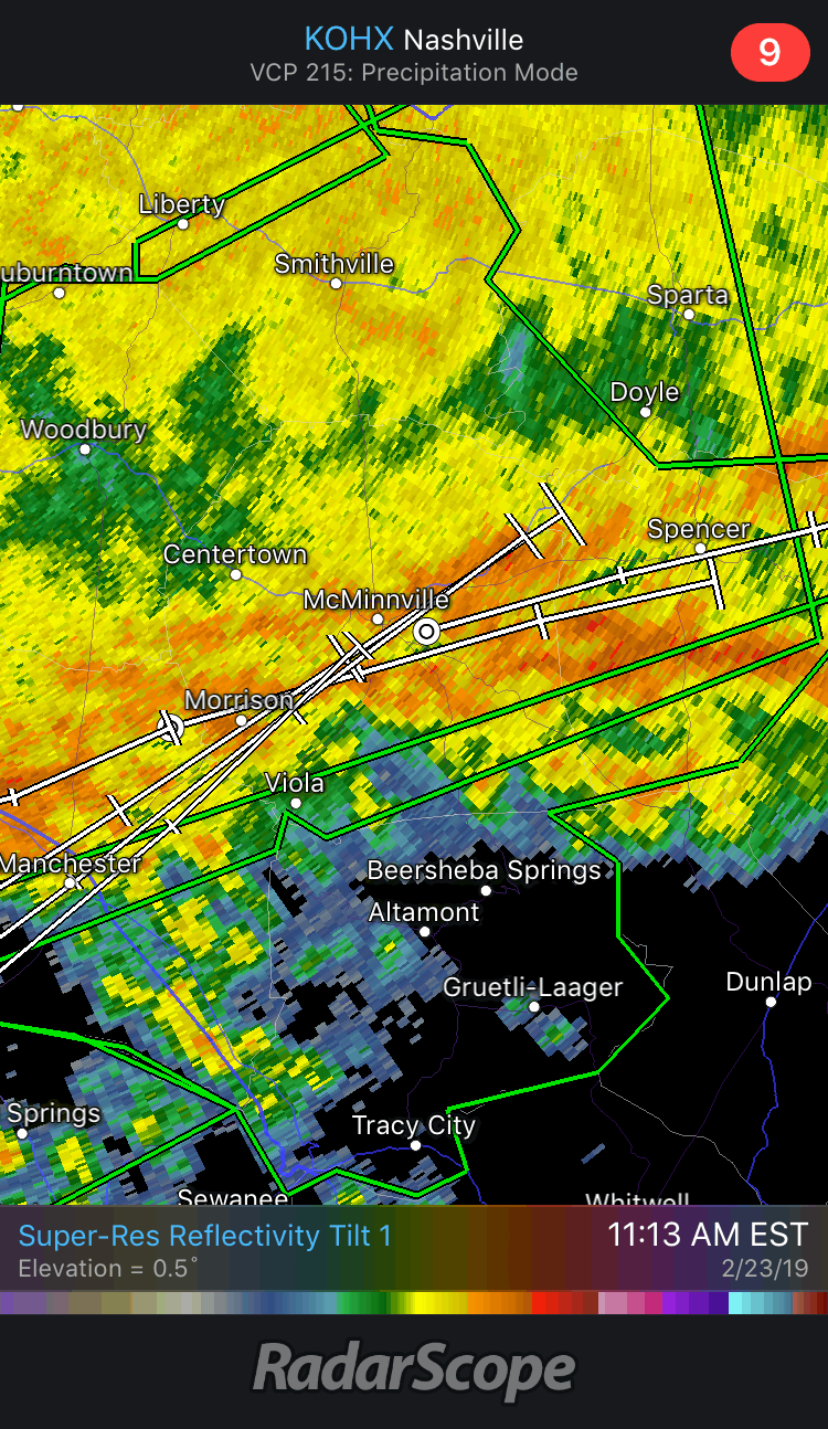
The train is arriving, and I’ll let the storm tracks tell the story. Stay safe, Knoxville friends.
-
TN valley heavy rain/flooding week of whenever
Blue Ridge replied to janetjanet998's topic in Tennessee Valley
It's going to be a photo finish. Storm tracks on KOHX are also showing slightly more ENE than NE. Watch the training cells move just south of McMinnville. From a hobbyist standpoint, this is fascinating to watch. Meanwhile, the stream in my front yard is slowly beginning to grow into a pond.