NJwx85
-
Posts
19,663 -
Joined
-
Last visited
Content Type
Profiles
Blogs
Forums
American Weather
Media Demo
Store
Gallery
Everything posted by NJwx85
-
Extreme Cold, Snow & Sleet: SECS 1/24 - 1/26
NJwx85 replied to TriPol's topic in New York City Metro
Don’t be shocked if the end result of this storm is about an 8 hour event that brings 4-8” of snow. Those saying the changes aloft on the Euro are just noise are being ignorant. A long duration event only happens if there’s a clean phase. Otherwise it’s overrunning and a scrape as the coastal gets kicked East. -
Extreme Cold, Snow & Sleet: SECS 1/24 - 1/26
NJwx85 replied to TriPol's topic in New York City Metro
Yup, not a clean phase. It trended towards the GFS with regards to handling the SW energy. -
Extreme Cold, Snow & Sleet: SECS 1/24 - 1/26
NJwx85 replied to TriPol's topic in New York City Metro
Having the UKIE moving towards the Euro is encouraging -
Extreme Cold, Snow & Sleet: SECS 1/24 - 1/26
NJwx85 replied to TriPol's topic in New York City Metro
There’s no phasing and it all gets squashed south. If that Southern piece doesn’t eject in time we’re finished. -
Extreme Cold, Snow & Sleet: SECS 1/24 - 1/26
NJwx85 replied to TriPol's topic in New York City Metro
It was North on Saturday night. -
Extreme Cold, Snow & Sleet: SECS 1/24 - 1/26
NJwx85 replied to TriPol's topic in New York City Metro
The GFS buries the Southern vort instead of ejecting it East. Closes off near Cabo. The Euro used to be notorious for this error. -
Extreme Cold, Snow & Sleet: SECS 1/24 - 1/26
NJwx85 replied to TriPol's topic in New York City Metro
The GFS is north about 200 miles so far out to 00z Sunday. Snow into the DC area vs the VA/NC border. -
Extreme Cold, Snow & Sleet: SECS 1/24 - 1/26
NJwx85 replied to TriPol's topic in New York City Metro
The 12z GFS is digging the trough into the Southwest a little deeper than the 6z Euro did but out to 12z Saturday they look very similar at H5. -
Extreme Cold, Snow & Sleet: SECS 1/24 - 1/26
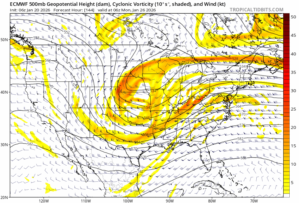
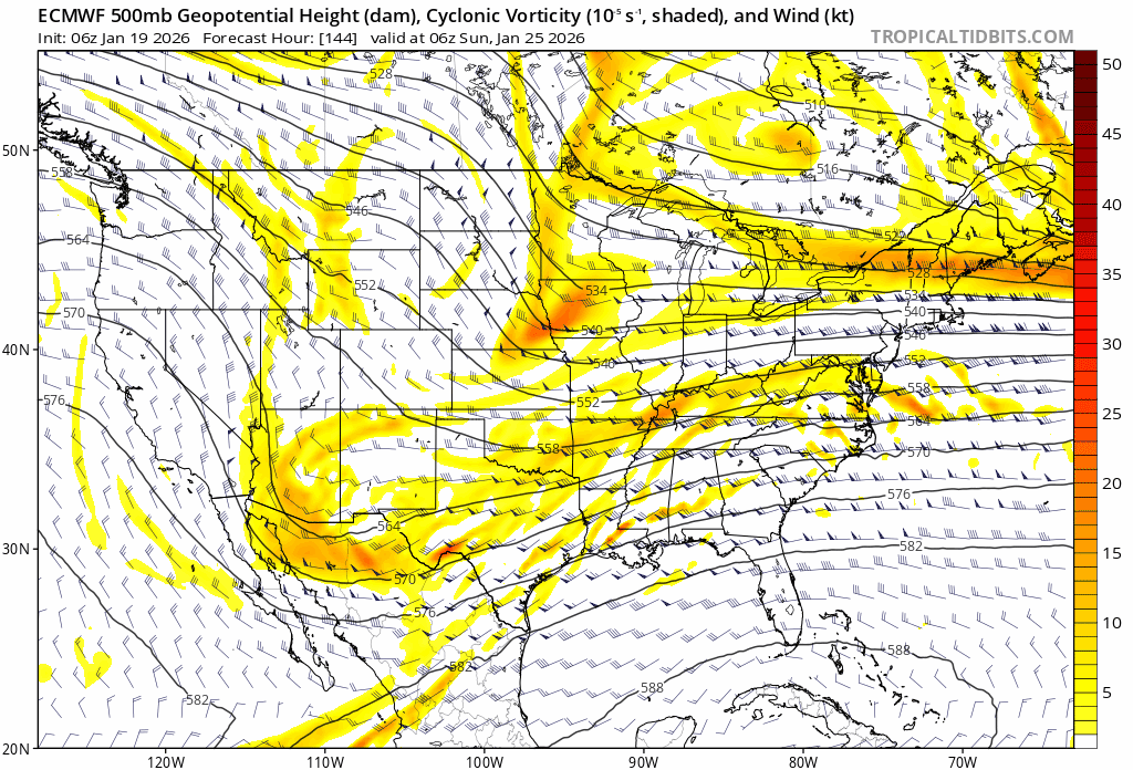
NJwx85 replied to TriPol's topic in New York City Metro
Today’s 06z Euro at 12z Sunday vs yesterday’s. What a difference.
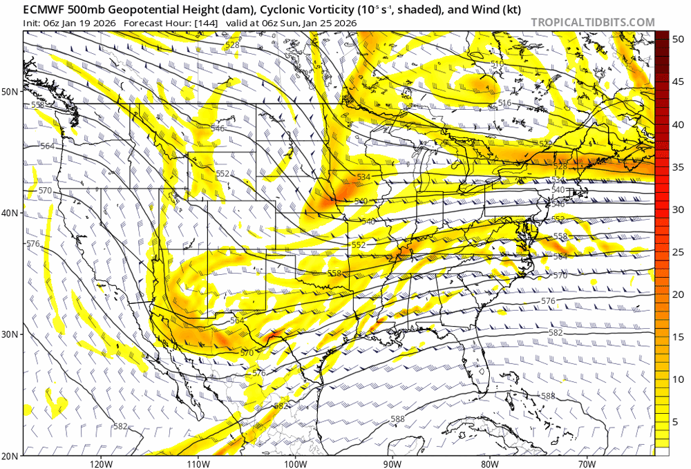
-
Extreme Cold, Snow & Sleet: SECS 1/24 - 1/26
NJwx85 replied to TriPol's topic in New York City Metro
GFS is North. -
Extreme Cold, Snow & Sleet: SECS 1/24 - 1/26
NJwx85 replied to TriPol's topic in New York City Metro
It’s actually been a decent winter for snow. But there’s no point in it being cold if it’s not going to snow. Cold and dry like the next few days are the worse in my opinion. -
Extreme Cold, Snow & Sleet: SECS 1/24 - 1/26
NJwx85 replied to TriPol's topic in New York City Metro
It’s setups like this that I can’t stand people that root for cold weather. As always, the cold has to be well timed and not too entrenched or it’s suppression city. I’d rather it be in the 60’s and sunny all winter with the occasional well timed cold and storm then a fridged winter where the track stays South. -
Extreme Cold, Snow & Sleet: SECS 1/24 - 1/26
NJwx85 replied to TriPol's topic in New York City Metro
Ratios on the Northern fringe could be as high as 20:1 but these storms always hit a brick wall at some point. Hopefully that brick wall is North of I-84. -
That’s too far West. January 96’ was over the TN valley. PD2 was a bit further North but the trough was similar. It’s really more about where the trough axis is. You essentially have a southern stream vort that’s acting like a speeding car running into a brick wall which is the dome of very cold and dry air. Sometimes it ends up too far South like 2010 because the NAO block is too strong. The MJO is entering phase 8 and propagating towards phase 1 so I’m really not surprised by all theses threats showing up. The PV is stretching and coming South so there will be a few week window for major storms until it retracts and the pattern breaks down at the end of February. Until then it should be open season for awhile. This is the best pattern we’ve had in years.
-
For this to really to go bonkers you’d want the trough to close off over the Tennessee Valley. Even so, there will be an insane amount of overrunning precip.
-
These always trend North at this range. I’d be worried right now if we were in the bullseye
-
Not trying to over hype but the setup next weekend has similarities with 96’
-
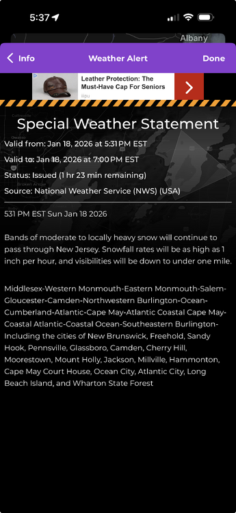
-
Radar has been slowly filling back in over Central and Western NJ. I’m expecting another 1-2” here but it hasn’t snowed here for several hours at this point.
-
This is classic windshield wiper model shenanigans. I wouldn’t write this off just yet but a glancing blow that happens Eastern New England is most likely.
-
The run to run differences at 500mb on the GFS valid at 06z Monday are laughable. Going to need a lot more than one run to get on board but it’s certainly possible in this pattern. The differences begin on Saturday with the trough digging further South which allows the flow to amplify just enough.
-
Snow season for the coastal plain unofficially ends in 35 days. Not that it cannot snow after Presidents Day, but it becomes much harder after that point due to a variety of factors. It will be disappointing if we manage to escape another Winter without a KU, especially after a very cold and snowy December around here, but it is what it is. Wave interference was the killer on this weeks threat and that seems to be the trend of the last few years. Too much activity and not enough wave spacing. Everything that ejects from the Southern stream gets kicked out before it can phase.
-
If we can get some decent blocking the pattern is ripe for a big Miller B.
-
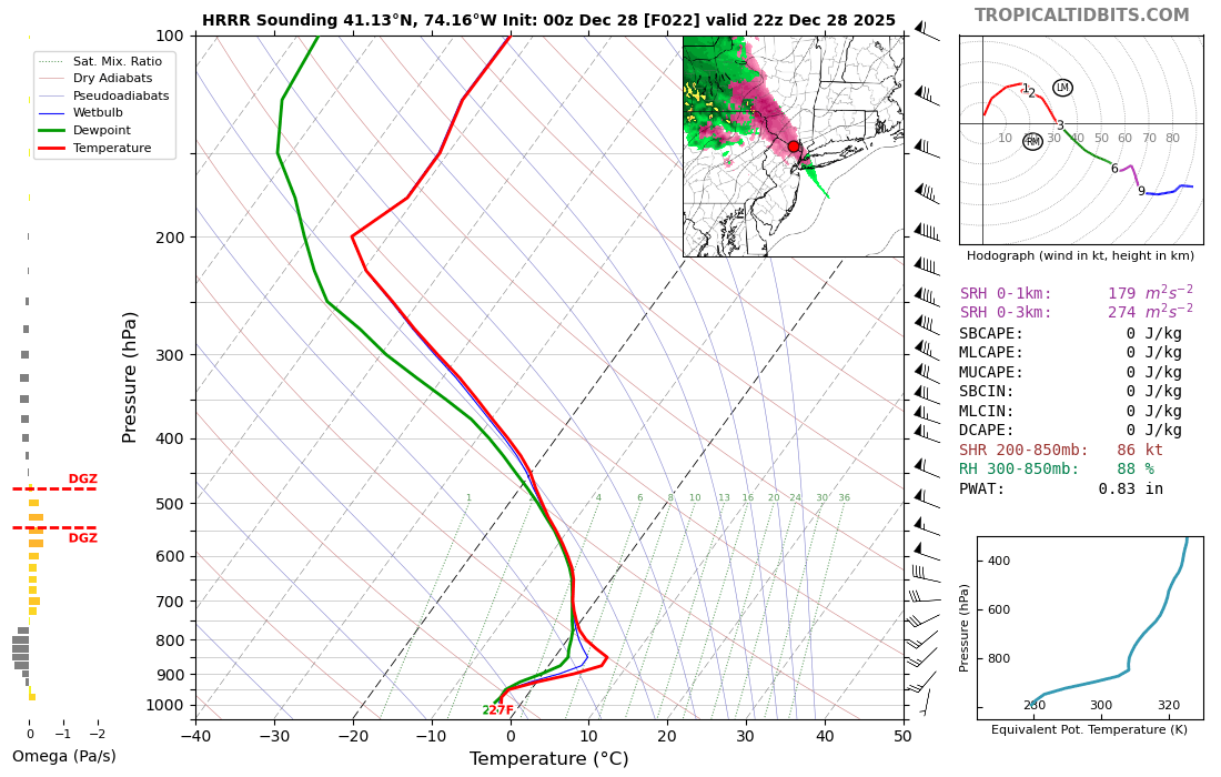
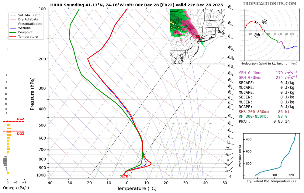
Good chance of some freezing drizzle and or light freezing rain tomorrow afternoon. 00z HRRR soundings show a classic ZR signature for parts of the interior.
-
I’ve been posting here for 15 years. My first big event was Boxing Day. Some here were in diapers then.