hlcater
-
Posts
2,686 -
Joined
-
Last visited
Content Type
Profiles
Blogs
Forums
American Weather
Media Demo
Store
Gallery
Everything posted by hlcater
-
The reply guys on Twitter really got to them
-
This is 2-3 days ahead of schedule in the Yucatán channel. As it meanders in a low shear environment what I’ll be watching for is if and how quickly a solid CDO/inner core develops. If we can get one going prior to shear increasing in 2-3 days, then the ceiling for this is much higher.
-
Don’t feel confident enough to commit to a major hurricane until we get a better idea of what shear will look like as this transits the gulf. With a very dry continental airmass lurking just west of the storm impacts of any shear could be exacerbated
-

2023 Atlantic Hurricane season
hlcater replied to Stormchaserchuck1's topic in Tropical Headquarters
Someone has not looked at a 500mb map for at least the last 10 days and it shows -
As the GFS now develops this system and there is 70% odds of development in the next 7 days, it's probably time for a thread on this one. It also doesn't look like the low is defined enough yet in the W carib to be designated as an invest, but when it presumably does, it'll be 93L.
-
nah
-
Looking closed on visible now
-
Maybe, but you also need just a little bit of shear and disorganization to get a singular updraft to be sufficiently strong to do that.
-
This is pretty neat
-
Lol I was about to come in here and say you could make an argument for classifying this based on vis. I didn't know recon is in there. Clearly a closed low on the eastern side of the convective shield. Also with the minimum extrap of 1000.5. Very nice little low in there.
-
2023 Atlantic Hurricane season
hlcater replied to Stormchaserchuck1's topic in Tropical Headquarters
Nice analysis here. Think of all the waves, the one with the best odds of being notable long term is the AEW just now leaving Africa. I think 90L develops into a TD/TS over the next day or so but dry air and westerly shear courtesy of the TUTT should keep a lid on that one. There is a chance that it stays disorganized and slides far enough south to avoid getting picked up and drawn northward, but the vigor of the wave currently kinda argues against that. Would expect it to be pulled up into the western atlantic with perhaps a rainfall threat in Hispaniola as it does so. -
With the way things are going on satellite, I am not convinced that we have peaked in intensity. Think we make another run at 125-130kts tonight. Recon will tell.
-
Not in the cooler waters yet. Probably by tomorrow AM though.
-
We'll also have recon tomorrow.
-
Classic deep tropical cane right now with the rapidly cooling CDO and expansive spiral banding in all quadrants. Feel like the ceiling is pretty high over the next 24-36 hours.
-
2023 Short/Medium Range Severe Weather Discussion
hlcater replied to Chicago Storm's topic in Lakes/Ohio Valley
Hodographs are rather small and lacking changes in speed/direction above 2km or so. But of course these are were pulled off globals and subject to change once higher res guidance gets in range. -
Money money
-
Someone is gonna pay for this. Exceptional thermos, adequate shear and a favorably oriented boundary suggesting an outside shot at a higher end MCS later today. Anecdotally, giant CAPE combined with very steep LLLRs (8.5-9.0) usually seems to correlate with strong downdraft potential. Additionally, with hodographs favorable for supercell development and LRs >7.5 throughout the column, would expect a large hail risk in the first 1-2 hours before upscale growth takes hold. One caveat could be the complete absence of a LLJ casting doubt in MCS maintenance potential, but that's something that's always confused me a little bit. There's no doubt a strong and coherent LLJ helps MCS maintenance/intensity, but how badly does an absent LLJ hurt? There are some very notable MCS cases that had zero LLJ to speak of.
-
Really liking how tonight's precip odds have.... quite literally.... evaporated.
-
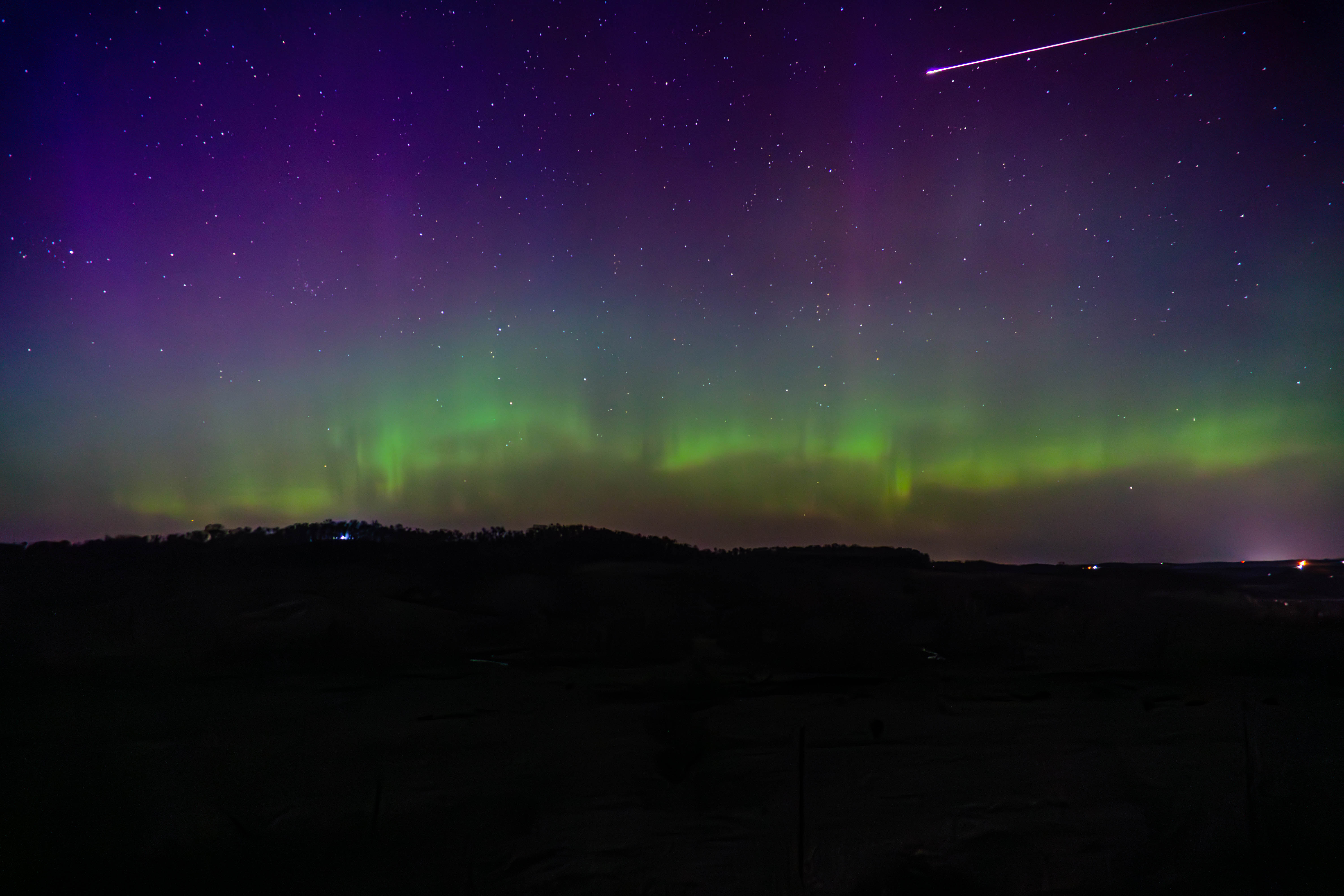
Late to the party, but here's what I came away with from Sunday's aurora. After seeing them for the first time somewhat haphazardly on 3/23, I put some more thought into it this time.

- 512 replies
-
- 22
-

-

-
Spring 2023 Medium/Long Range Discussion
hlcater replied to Chicago Storm's topic in Lakes/Ohio Valley
The biggest issue with 4/19 and 4/20 is wave timing. The primary wave is a bit too far west on 4/19, which would still be workable in W IA, but most models have a shortwave traverse the area the morning of 4/19 which veers the LLJ off to the east with it. That leaves us with 4/20 which has the primary wave ejecting, but probably a bit too quickly to maximize the risk. The Euro's solution is almost good, with primed soundings at 18z across SE IA and W IL, but the wind fields again veer out later in the day and a strongly forced cold front surges east as the wave closes off aloft, doesn't exactly scream visible tornadoes to me. Could see either one of these trending into a somewhat decent local day, but it's difficult to say which one is the better of the two at the moment. -
Dude be careful out there. Losing situational awareness can total your car or worse. Other chasers were also hit by tornadoes from this storm and fared far worse than you did. Despite what some may say, 0 metering is not worth it in most cases. Oftentimes the 100-250 meter shot is better anyways
-
Went out and saw quite literally nothing. Screwed by the Ft. Madison bridge crossing and not willing to core the baseball sized hail necessary to get ahead of the storm, just gave up and went home.
-
mix mix mix