hlcater
-
Posts
2,686 -
Joined
-
Last visited
Content Type
Profiles
Blogs
Forums
American Weather
Media Demo
Store
Gallery
Everything posted by hlcater
-

Winter 2024-25 Medium/Long Range Discussion
hlcater replied to michsnowfreak's topic in Lakes/Ohio Valley
Real chance we go into february here with under 5" of seasonal snowfall and BA temp anomalies... -
3" on the nose today. More than tripling my season total coming into today in Iowa City
-
NAM at 84 tends to be north so not putting a ton of stock in that. As others have said, not really gonna put money in this coming north until there's a marked trend of this system doing so.
-
Winter 2024-25 Medium/Long Range Discussion
hlcater replied to michsnowfreak's topic in Lakes/Ohio Valley
I’m here to promote high quality discussion with fellow winter weather enthusiasts like me!!!!! -
Winter 2024-25 Medium/Long Range Discussion
hlcater replied to michsnowfreak's topic in Lakes/Ohio Valley
I just want to get pasted with the white stuff -
Yea that system tuesday could drop some cement out here if things trend right. NAM/Euro anecdotally have seemed to handle these setups pretty well in the past and they're the ones showing snow this time so I guess we'll see.
-
Winter 2024-25 Medium/Long Range Discussion
hlcater replied to michsnowfreak's topic in Lakes/Ohio Valley
I think this is probably the most likely outcome. AA for sure but I’m not convinced that we get crazy anomalies rainers for days tho -
DAB+ out there to whiten things up
-
Winter 2024-25 Medium/Long Range Discussion
hlcater replied to michsnowfreak's topic in Lakes/Ohio Valley
Comatose this far west so far and probably until at least Christmas -
Yea this thing is in free fall again…
-
Nope still straight as an arrow en route
-
To this note I really think the only big thing that will limit Milton *is* shallow shelf waters as it passes near/south of scorpion reef.
-
Keep in mind that core dynamics during RI and the atmospheric environment (ie atmospheric temps aloft) are also contributors to MPI, not just OHC.
-
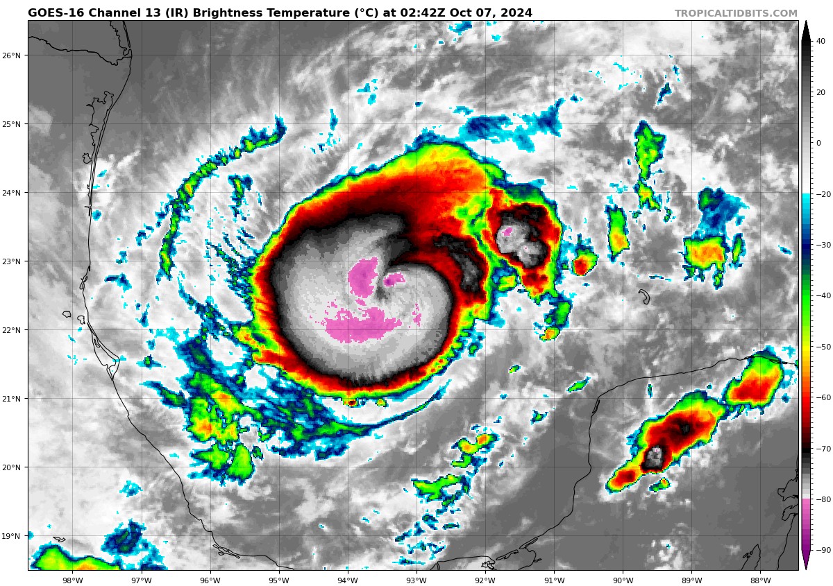
That look combined with NOAA43's radar scans earlier and 11nmi RMW.... ooof. Expecting substantial strengthening tonight. Could wake up to a major.

-
This is extremely important and worrying for surge. Massive hurricane force wind field combined with coastal geometry could easily yield 20+ft surge in spots.
-
Was thinking it's either attenuation or subsidence caused by strong eyewall convection that caused the opening. Could even be both. In any case IR continues to improve on a rapid pace. Should have recon data within the next 30 min.
-
Numerous mesovorts with a pentagonal eyewall on Tampa bay radar now. In the past these pentagonal eyes have been harbingers of RI. May be something to watch for as we close in on landfall
-
I don’t mean to rain on your parade but posting satellite and radar gifs every 15 min is unnecessary and clogs the thread seeing as we all have access to it.
-
Definitely legit too. Look at the temp spike/Td drop associated with it
-
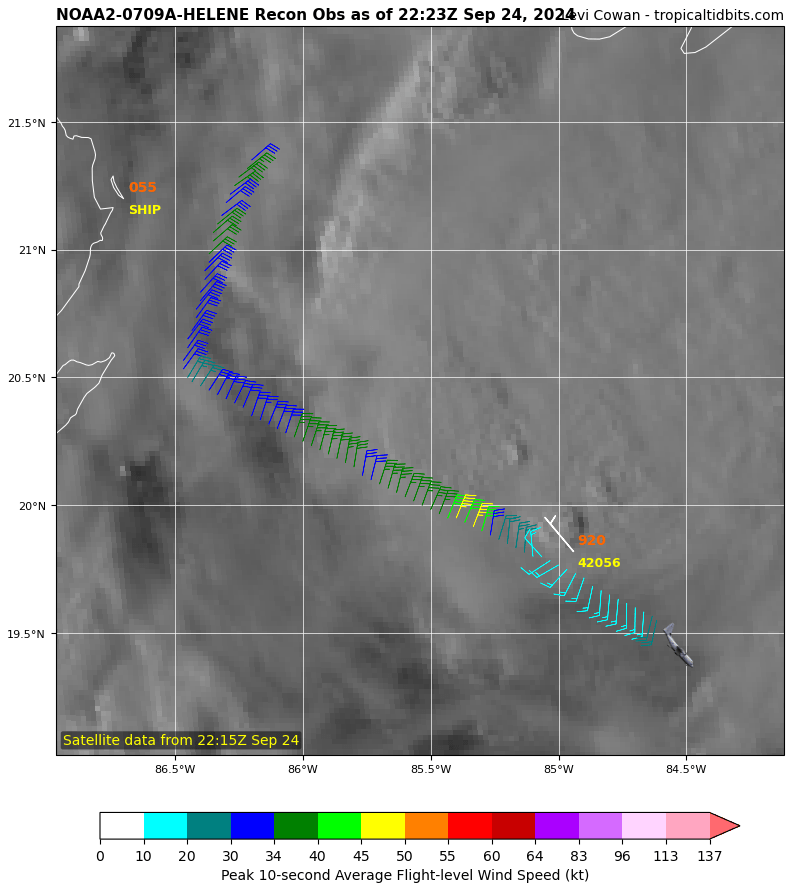
Recon just got the first fix of the evening. 990.5 extrap

-
Starting to wonder if this starts building an inner core sooner rather than later. The surface circulation is already well defined and appears to be becoming stacked under the sprawling mid-level circulation. This process seems to be complicated only by dry entrainment off of Cuba’s higher terrain, with deep convection widespread in all 4 quadrants otherwise. I’m not seeing much reason why a quicker pace of intensification shouldn’t ensue once that gets mixed out, especially if convection continues to develop over the center.
-
Slow to the punch on this one but it took me awhile to get all these put together since I still really dont know what I'm doing. All timer at these latitudes for sure.
-
- 65 replies
-
- 13
-

-
Probably 6" out there right now. Flake size has been small to pixie dust during the entire event. Hoping the coherent defo band out west holds on as it translates east. Otherwise, just gonna be pretty light stuff the rest of the evening. Could still pick up 1-2" but over the course of 7-8 hours...