Normandy
-
Posts
813 -
Joined
-
Last visited
Content Type
Profiles
Blogs
Forums
American Weather
Media Demo
Store
Gallery
Everything posted by Normandy
-
That’s big deal if verified. The rain alone is enough to be record setting. The wind is the cherry on top. I’m officially on alert as a resident of LA
-
There might need to be serious convos about a tropical cyclone strike on so cal
-
2023 Atlantic Hurricane season
Normandy replied to Stormchaserchuck1's topic in Tropical Headquarters
If the GFS is to be believed, we see three named storms at least before august ends. Other model consensus also coming into agreement. The bell has been rung! -
2023 Atlantic Hurricane season
Normandy replied to Stormchaserchuck1's topic in Tropical Headquarters
Agree the pot is getting hot and storms are going to form soon. Not seeing an august shut out at all based on current modeling. Even a look at satellite one can see very discernible waves / future lows in the gulf and near the Bahamas. -
2023 Atlantic Hurricane season
Normandy replied to Stormchaserchuck1's topic in Tropical Headquarters
My running theory is that as waters warm and stay warm later into the winter months, nor’easters will start to become more powerful and damaging (basically superstorm Sandy’s become more frequent) . Fun speculation during these dog days of hurricane summer -
2023 Atlantic Hurricane season
Normandy replied to Stormchaserchuck1's topic in Tropical Headquarters
It’s less about name wasting and more about consistency. 97L to my untrained eye looks like more than a frontal low. I’ve seen stuff like this named before. Very deep convection and obvious LLC.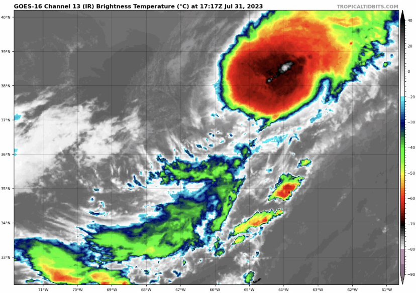
-
2023 Atlantic Hurricane season
Normandy replied to Stormchaserchuck1's topic in Tropical Headquarters
People agree with the NHC in this? That looks like a TC to me -
2023 Atlantic Hurricane season
Normandy replied to Stormchaserchuck1's topic in Tropical Headquarters
I think we got a TC out of 97L -
2023 Atlantic Hurricane season
Normandy replied to Stormchaserchuck1's topic in Tropical Headquarters
Not sure why Don hasn’t been upgraded yet. I get it’s not a threat to land but a hurricane is a hurricane -
Agree. This will do enough to get named but I don’t think it will do much.
-
2023 Atlantic Hurricane season
Normandy replied to Stormchaserchuck1's topic in Tropical Headquarters
95L looks very classifiable to me. Small but very well defined circulation with persistent convection. -
2023 Atlantic Hurricane season
Normandy replied to Stormchaserchuck1's topic in Tropical Headquarters
Data from the ECMWF and UKMet in Dr. Knolls superblend are still suggestive of an active hurricane season despite the El Niño. Still guessing we get a lot of named systems but perhaps not a lot of strong ones. -
2023 Atlantic Hurricane season
Normandy replied to Stormchaserchuck1's topic in Tropical Headquarters
We have already had three named storms though. Not seeing anything right now that would suggest anything different from two weeks ago? Are you seeing different forecasts coming out that suggest a lower than normal season (well lower than predicted I guess) -
The storm is completely decoupled at the mid and low levels it appears. Interesting note by the NHC there on the recon data which seems to support this.
-
That's wild! Would those be considered separate tornadoes or multi-vortex? Kind of blurs the line at times. Thanks for sharing.
-
2023 Atlantic Hurricane season
Normandy replied to Stormchaserchuck1's topic in Tropical Headquarters
93L has two vorticity centers…one around 10N which is being used to designate/track the invest. And another near 5 N. Should be fun to track. Crazy how much activity there is this early -
2023 Atlantic Hurricane season
Normandy replied to Stormchaserchuck1's topic in Tropical Headquarters
The wave behind 92L looks just as good right now. We might have 2 MDR systems come this time tomorrow. -
2023 Atlantic Hurricane season
Normandy replied to Stormchaserchuck1's topic in Tropical Headquarters
GFS is showing a gyre like system that dominates the gulf for the near future. Interesting to see how that feature develops. Seems like it would be a crazy rainmaker for the south. The “phantom” is now a strung out mess that gets absorbed into the aforementioned gyre -
2023 Atlantic Hurricane season
Normandy replied to Stormchaserchuck1's topic in Tropical Headquarters
It’s not on an island though. The euro also shows this vorticity now. The timeframe has been consistent as well. I hear the GFS produces phantoms but one needs to look at all the evidence before just blabbering “phantom”. It’s lazy analysis -
2023 Atlantic Hurricane season
Normandy replied to Stormchaserchuck1's topic in Tropical Headquarters
while the MDR system is interesting, the WCAR system is the one we should be watching. GFS looks like it’s gonna win huge with this one, lots of people discarded it’s solutions and laughed. -
2023 Atlantic Hurricane season
Normandy replied to Stormchaserchuck1's topic in Tropical Headquarters
GFS very consistent run to run….having a higher confidence this isn’t a phantom -
The system is heavily sheared but has good vorticity and likely will keep generating strong convection in the eastern quad. I think recon will eventually find the winds to upgrade it at some point me. Nothing major but I see a low end TS out of this. as mentioned before the motion is interesting and atypical for june.
-
This one looks like it might get classified
-
Wild mesovortex action going on this storm!
-
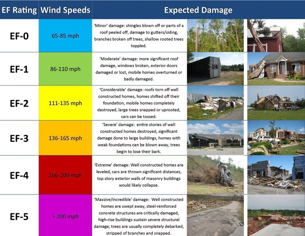
What’s even more maddening to me is their description of EF-5. The wording they use they don’t even follow during their damage assessment. It does not mention these anchor bolts they always use as reason to not give the EF-5 rating. If they would just simply follow their own words as a guide would immediately get better results when rating these tornadoes.