

Normandy Ho
-
Posts
3,295 -
Joined
-
Last visited
Content Type
Profiles
Blogs
Forums
American Weather
Media Demo
Store
Gallery
Everything posted by Normandy Ho
-
“The storm itself wasn’t super bad it’s just humanitarian crisis it caused was” is one of the funniest things I’ve ever read. And that’s where I stopped reading lol
-
I’m proud of you for reading through it all, sheesh
-
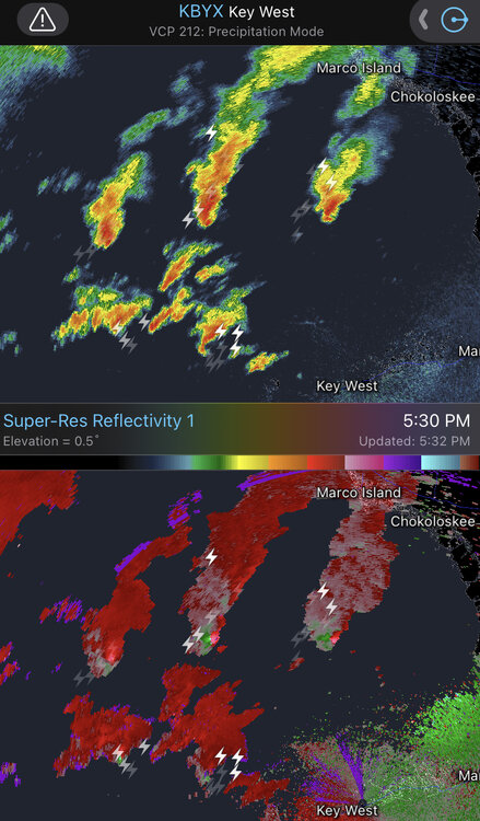
Brother I count five black swans in the image I posted. If these same conditions are present tomorrow morning there is gonna be a tornado outbreak over FL before the core of the cane comes in. It’s incredible to see these high end hurricanes and what they can do
-
This. Lots of “it won’t happen to me” to “I’ll roll the dice because im broke and can’t afford to leave”
-
Posted the is is the banter thread regarding the evolving tornadic setup. Lots of low level shear being caused due to Milton’s insane vortex to the SW
-
Tornado / waterspout outbreak occurring offshore west coast of florida

-
Bruh seeing it slide east every time it rapidly deepens is spooky as fuck. Very unnatural for a cane where it is
-
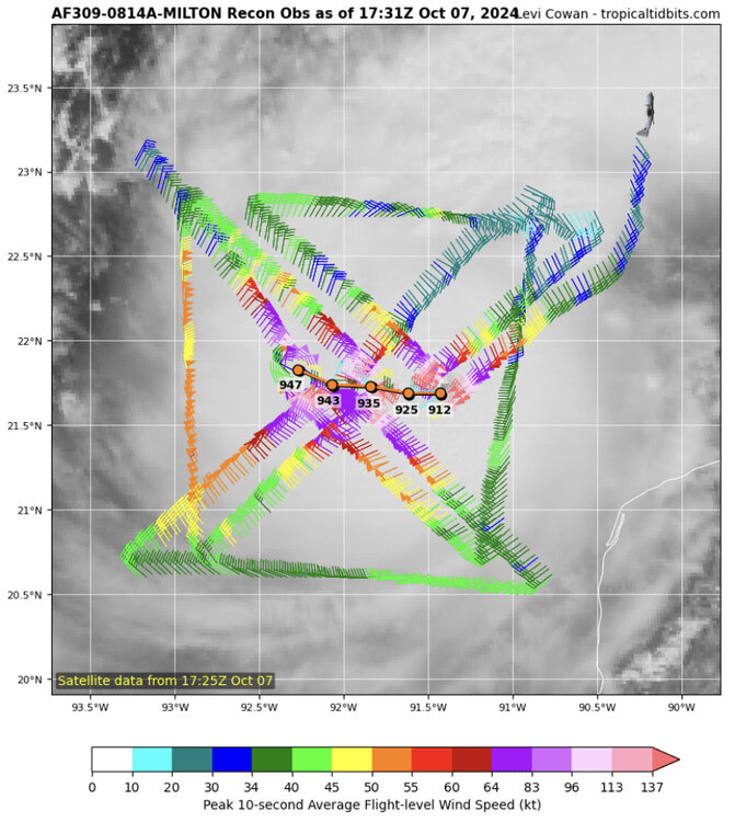
On pins and needles waiting for recon
-
Great post. This is why it’s hard to automatically assume a storm will be impacted by shear once it has gone to pound town already. Hurricanes this powerful tend to have unexpected interaction with the upper level elements that induce the shear. Love watching these interactions unfold
-
If you don’t see the posts it’s because the mods are working bruh
-
Perhaps but I think this might be more structural changes. Shear doesn’t really kick in until it starts sliding northward. Like others have said shall be an interesting day to see what Milton does
-
Classic ERC ongoing. My worry is it’s too early (would hav even nice to start when it turns more north and begins to feel the shear). Let’s see what it does tonight
-
This bruh. You’re telling me we are seeing this shit AFTER helene? We fucked this climate up
-
Milton putting on a clinic right now. Posted for posterity but we got on record a 35 mb drop for this flight alone. Absurd and we are blessed to be watching this show
-
This is gonna break the GOM pressure record. It’s falling too fast not too
-
Bruh this hurricane is stupid dumb. Ain’t ever seen shit like this
-
I would focus on whether or not the models are showing weakening upon approach (which GFS seems to be showing steady state). The globals can’t resolve the pressure of these systems completely accurately. I’m sure mets can chime in on this
-
Milton bruh!
-
It’s just an enhanced area of convergence due to Milton’s circulation slingshotting low level flow NW and then rapidly pulling it back ESE. Many severe canes have these appendages but I wouldn’t worry about it affecting track or intensity
-
Milton putting on a clinic right now
-
stunning intensification. Another generational hurricane heading towards Florida (seems like generational is being used too much these days)
-
Deepening is so rapid that the west eyewall is stronger than the east. Tomorrow will be a very stressful day for Florida. And this is on It’s way to cat 5 status
-
Yea the southern eyewall of an east moving cat 5 scraping the coast would def be unusual for them. Any direct interaction with the Yucatán though likely removes major hurricane possibilities for Florida considering the shear present and movement over the cold pool north of the Yucatán coast. Something to watch for sure
-
2024 Atlantic Hurricane Season
Normandy Ho replied to Stormchaserchuck1's topic in Tropical Headquarters
Unfortunately the pattern is ripe for TCG in the Caribbean and movement north. Trying times ahead for Florida. The insurance industry there might not survive this season -
Don’t show y’all’s ass this time


