Normandy Ho
-
Posts
3,295 -
Joined
-
Last visited
Content Type
Profiles
Blogs
Forums
American Weather
Media Demo
Store
Gallery
Everything posted by Normandy Ho
-
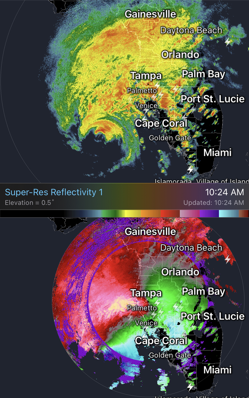
To put it in perspective the El Reno tornado was 2.6 miles wide, barely smaller than this eye
-
For sure. But yesterday when it was passing north of PR there were signals it had a closed circulation. I think the NHC overall has a more conservative policy re: Naming systems and that’s fine, but you might run into situations like today where Oscar suddenly appears. I hear your point though
-
No other way around it the NHC dropped the ball here
-
Is what it is bruh the NHC is DONE after Helene and Milton if land isn’t on the table lol. And I get it, but this has been a slop TC for a minute
-
Aged well bruh!
-
Serious question. Why is this not named? I don’t understand the NHCs policy with respect to naming tropical cyclones. I mean I get that we don’t want to waste man power on useless advisories for a namewaster, but then let’s change the criteria
-
That’s a good shout. Tracy is an interesting case study and makes me wonder if it was a bit more intense than realized. A cyclone that small is essentially producing a tsunami like water rise which has to have tremendous wind to generate it at such a small and localized scale
-
The only small storm I can think of that produced a significant surge was hurricane Andrew (16 feet I believe). For the small storm to produce substantial surge it basically has to be a cat five nuclear grade cane. Even charley didn’t produce much.
-
Very odd track on this one.
-
Agree. The surge values can’t be assumed to be extreme because the storm is a cat 5 l. I would argue the biggest indicator of severe surge is the radius of TS force winds. That is something that Katrina, Helene, and Ike all had common
-
2024 Atlantic Hurricane Season
Normandy Ho replied to Stormchaserchuck1's topic in Tropical Headquarters
I mean we are in mid October and the GFS is still showing signs of life at 384. I’m hopeful but Jesus man this season taking 6 weeks off during prime time and backloading it is unreal -
This. It’s so apparent
-
2024 Atlantic Hurricane Season
Normandy Ho replied to Stormchaserchuck1's topic in Tropical Headquarters
The fact that we have already experienced the costliest hurricane season on record and are facing potential threats until mid November is very sobering. -
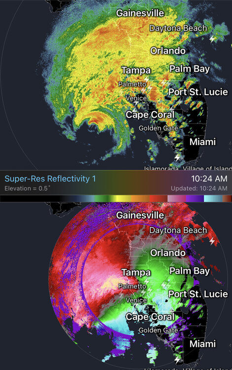
The tornado outbreak on that radar loop…what a beast of a storm
-
Meteorologically speaking, the most interesting thing easily is the historic and unprecedented tornado outbreak this system produced. Nobody will ever say this out loud and it will never be recorded a historical fact, but yesterdays tornado outbreak was potentially one of the biggest numbers wise in US history. half of the event the tornadic supercells went offshore and thus warnings stopped. I said this yesterday but if there was more land to the east the number of tornado warnings and confirmed tornadoes would have doubled. You would have had well over 200 warnings and 30 confirmed. In FLORIDA.
-
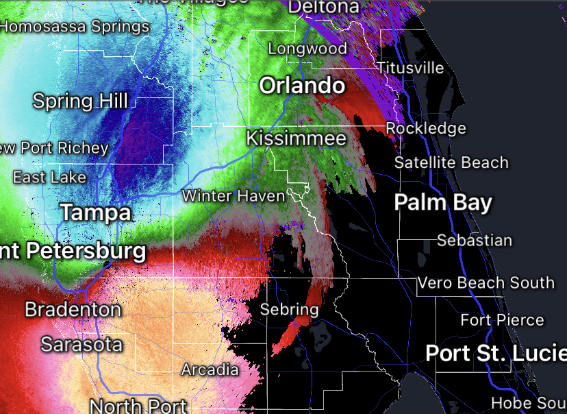
I thought Helene was impressive inland but this might even be wilder. Still showing very strong winds aloft. One has to wonder once it gets to the east coast of Florida is it going to intensify?
-
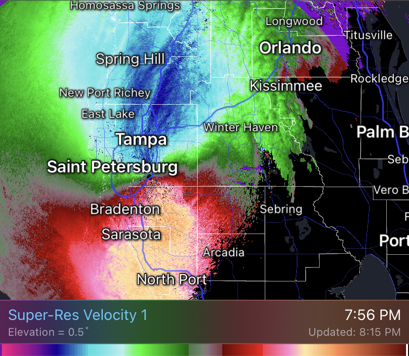
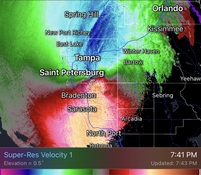
Velocities are increasing from the last post I made. Incredible storm
-
Not totally true. The south side produced the best winds (92 sustained, 107 gust) because of the sting jet. To be fair the north side was strong too. It was a very symmetrical storm
-
Brother I was texting my family in Palm Bay. I literally had to tell them shelter in place because there were so many warnings and the cells were training I couldn’t even tell them where it was coming from. The violent fucker that went through Vero beach just missed them to the east.
-
If there was land east of Florida this would be the biggest tornado outbreak numbers wise in US history. The outbreak never stopped it just moved offshore
-
Once again strong winds occurring well after landfall. Going to warn my family in Palm Bay on the east coast of Florida (they thought the tornadoes were the end of it).
-
Don’t y’all losers get tired of constantly showing your ass each storm? 92 sustained at Venice now. Several gusts in the 90s on the north side: the fucking tornado outbreak. Y’all losers can’t be satisfied. Storm was a fucking banger
-
The tornado outbreak occurring ahead of the tornado will exacerbate wind damage when the actuall hurricane arrives. Just another example of how powerful storms can cause unusual weather outcomes because the tornado outbreak occurring definitely was not expected on this level. I’m certain the eastward expanding windfield and shear combo had something to do with this. Would love a Mets thoughts
-
I mean that’s better than 20 miles south of tampa but ya gonna be close bruh. If I was where you are looking at this moving anywhere near me I’d be nervous
-
Where do you live?