

Normandy Ho
-
Posts
3,295 -
Joined
-
Last visited
Content Type
Profiles
Blogs
Forums
American Weather
Media Demo
Store
Gallery
Everything posted by Normandy Ho
-
You just have to hope it comes in south of tampa. It will be very lopsided to the south and east so if you keep the major winds south of tampa you spare the most
-
I still like a south of Tampa solution. I think it’s going to get too far east before turning NE. If I were to make a call just north of fort meters at cat3-4 intensity
-
2024 Atlantic Hurricane Season
Normandy Ho replied to Stormchaserchuck1's topic in Tropical Headquarters
Scary hours right now in the ATL basin -
If I am gauging the ensemble and op runs correctly, it appears a faster moving system comes in further north as it doesn't allow time for the mid-level steering flow to arc back ESE. A slower moving system gives time for the TC to get pushed further east than perhaps even ESE as the strong mid-level trough powers across the peninsula. You can even watch that flow evolve from the 850-400 hPa level and the mid-to-upper ST jet. That may explain why some of the slower modeling wants to bring this in down near Sarasota to even the Keys. Something to watch for with each modeling suite. I favor slower moving and stronger. South of tampa. Maybe even Miami dade could be involved. Very wild setup
-
unfortunately I’m bullish on this one too. GOM version of Lenny
-
2024 Atlantic Hurricane Season
Normandy Ho replied to Stormchaserchuck1's topic in Tropical Headquarters
Was gonna say it might be time. Starting to see a semblance of a circulation near the coast in the BOC -
@Windspeed is correct. This storm was exceptionally assymetrical. To get big winds one simply has to be east of the center. The Cat4 winds were absolutely there though at landfall. The inland wind event does not occur if the cat 4 winds aren’t there at landfall
-
Putting on a show!
-
This was a rare hurricane where all three phases were deadly. - Deadly surge at the coast over a tremendous area soaking a hundred+ miles - Deadly wind that translated inland over hundreds of miles. thankfully said wind didn’t hit any major metro centers at the coast (which is the only saving grace of this cane) - deadly flooding which at this point is reach historic and unseen before levels
-
This is the modern era though. Losing more than 100 in a cane is rare. Losing hundreds or even a thousand back then not so much. Tech now saves lives and that same tech didn’t help this time which to me makes Helene more severe. If Helene came in under the same conditions we had in the 1800s the death tolls would be in the ten of thousands
-
This one is a safe bet to stay away. Too strong too far east and not enough ridging
-
The story is still being written and the dust hasn’t settled, but I’m going to wager when all is said and done hurricane Helene will be the most severe/devestating hurricane strike in United States history. The amount of people this storm has affected is unimaginable. if we were to go back in time when this was a naked swirl In the Carribbean and I were to tell you that this was the outcome: 938 mbs, 140 mph winds with the strongest wind passing over marshland, and Tallahassee unaffected. The result: 1,000 dead (TBD) and 120 billion in damage. I’d be laughed off the board. What this storm did is wild man.
-
Yep this is the ACE monster of the year
-
excellent posts by everyone. I personally believe that the high winds inland were caused by the interaction with the upper level low. Beryl had a similar setup and had similar effects, however beryl was a cat 1 while Helene was a cat 4. Additionally Helene was just much more of a monstrous storm, but would love to hear more thoughts on why the winds traveled so well inland
-
2024 Atlantic Hurricane Season
Normandy Ho replied to Stormchaserchuck1's topic in Tropical Headquarters
This was the potential of this season and now we are here. And nobody wants to say it or believe it but this next one will be strong as fuck too. Hopefully it stays small in size at least -
There are some extremely strong winds on the east side off this system
-
Indeed Hugo was another inland monster. Great analog to this one
-
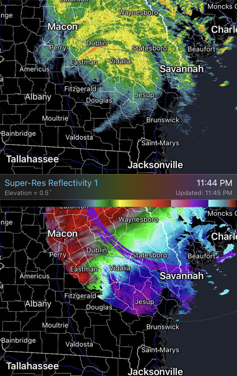
Visuals for reference. Insanity with these strong winds so far Inland
-
Yea brother y’all are taking a hit from this one. The phase with the low to its west is giving it some sauce as it moves inland unfortunately
-
Generational brother. Insane inland wind event
-
Just a beast of a storm. Capture and put hands on everyone
-
Posted for posterity. Not often you see this
-
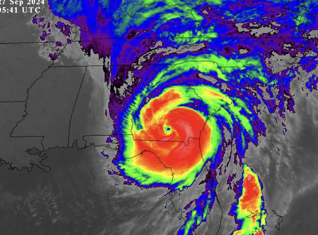
Cannot rule out a brush with cat 5 intensity. Like I said yesterday generational hurricane. Radar Velocities and lighting are insane
-
So many of y’all had ya asses out today lol
-
This. Storm will smash surge records for the region and it’s going to be absolutely cranking when it comes ashore.


