Normandy Ho
-
Posts
3,295 -
Joined
-
Last visited
Content Type
Profiles
Blogs
Forums
American Weather
Media Demo
Store
Gallery
Everything posted by Normandy Ho
-
2024 Atlantic Hurricane Season
Normandy Ho replied to Stormchaserchuck1's topic in Tropical Headquarters
I think it be that time fellas and ladies. This one needs a new thread -
Big rainfall totals will be seen there. Debby has a tail that is long and will train over Tampa as it moves NE.
-
Substantial velocity increases. No doubt it's in an RI cycle now. enjoy the show.
-
Yea its about to get nasty. Big tower coming in. eyewall developing on radar. Gainesville might get a very good hit from this (think houston in beryl).
-
Really starting to crank now. Velocities on radar starting to increase. multiple convective blow ups occurring.
-
Yep. A long loop can be created documenting all phases. genesis, vortex coupling, failed and successful intensification attempts, and finally now its RI cycle.
-
Good news is this one will be in radar range the entire time until landfall. Still think it starts to intensify quickly tonight
-
I’m in the camp of “intensity forecasts are way underdone”. Can’t rule out a major at first landfall. It’s way way ahead of schedule and deepening quickly already. Models have always suggested this will be deepening on approach, suggestive of a favorable environment. I am interested in where the stall occurs.
-
Think they might need to pull the trigger soon. Lots of low level turning now and A good deal south of Cuba too.
-
Yea I was going to say, the consolidation looks to be happening just east of grand cayman. Would a stronger storm initially be influenced to hook more hard right in this setup?
-
A lot of the vorticity seems south of Cuba this morning. Not sure it affects track too much but it may have more time over water if it consolidates south of Cuba while moving WNW
-
I think the takeaway is as the storm first approaches the coast conditions begin to get very favorable, and continue to be so as the storm stalls. As @Windspeedsaid land interaction is key. Upwelling also might become a factor if it gets very intense before the stall
-
Yessir! First call is a stall somewhere west of Florida. Complicated setup with blocking madness
-
2024 Atlantic Hurricane Season
Normandy Ho replied to Stormchaserchuck1's topic in Tropical Headquarters
Thanks for the opportunity brother but I’m not disciplined enough to keep the titles updated lol. It’ll stay as a TD in the title thread throughout its life -
2024 Atlantic Hurricane Season
Normandy Ho replied to Stormchaserchuck1's topic in Tropical Headquarters
Very interesting scenario being pointed by the models. Lots of rain coming for someone as the storm gets stuck and trapped. The euro even has it moving SSE across Florida and then up the east coast. Might be time for a separate thread? -
2024 Atlantic Hurricane Season
Normandy Ho replied to Stormchaserchuck1's topic in Tropical Headquarters
Still some uncertainty as there is disagreement between the big dogs. GFS seems to be somewhat caving to the euro as it’s abandoned the idea of sending this west after the stall. Euro still thinks this is an east coast brusher. -
2024 Atlantic Hurricane Season
Normandy Ho replied to Stormchaserchuck1's topic in Tropical Headquarters
Not seeing the juice with this one. Interesting how the euro and GFS seem to be split in two camps with respect to ultimate track -
2024 Atlantic Hurricane Season
Normandy Ho replied to Stormchaserchuck1's topic in Tropical Headquarters
I think compared to this board the level of expertise and knowledgeable posters is just severely lacking over there. Additionally the moderators are absolutely childish and squash any and every inkling of disagreement. They treat posters like they are children which is ….. yea not for me. I was a longtime member there and when I found this place I never posted there again -
2024 Atlantic Hurricane Season
Normandy Ho replied to Stormchaserchuck1's topic in Tropical Headquarters
You are doing the good work sir of sifting through the garbage to find the good stuff for us over here. You should get chris / wxman57 to come over here. That board is a wasteland What’s weird about this disturbance is…..where is it? I looked at satellite and there’s just jack shit out there. Gonna be interesting to see this unfold because the models are clearly latching onto something. Seems like a pattern for some kind of recurve near the east coast? -
2024 Atlantic Hurricane Season
Normandy Ho replied to Stormchaserchuck1's topic in Tropical Headquarters
I do think overall numbers will underperform. I think I called for 26 total but I’m bringing that down a bit. I still think we get tons and tons of majors though -
Gotta love the mini hurricane looking tornadic tropical supercells

-
Tropical Cyclone Tornado Outbreak: Beryl
Normandy Ho replied to Quincy's topic in Central/Western States

-
Tropical Cyclone Tornado Outbreak: Beryl
Normandy Ho replied to Quincy's topic in Central/Western States
Yep beryl is wreaking havoc on the south today. Some of these hooks are scary -
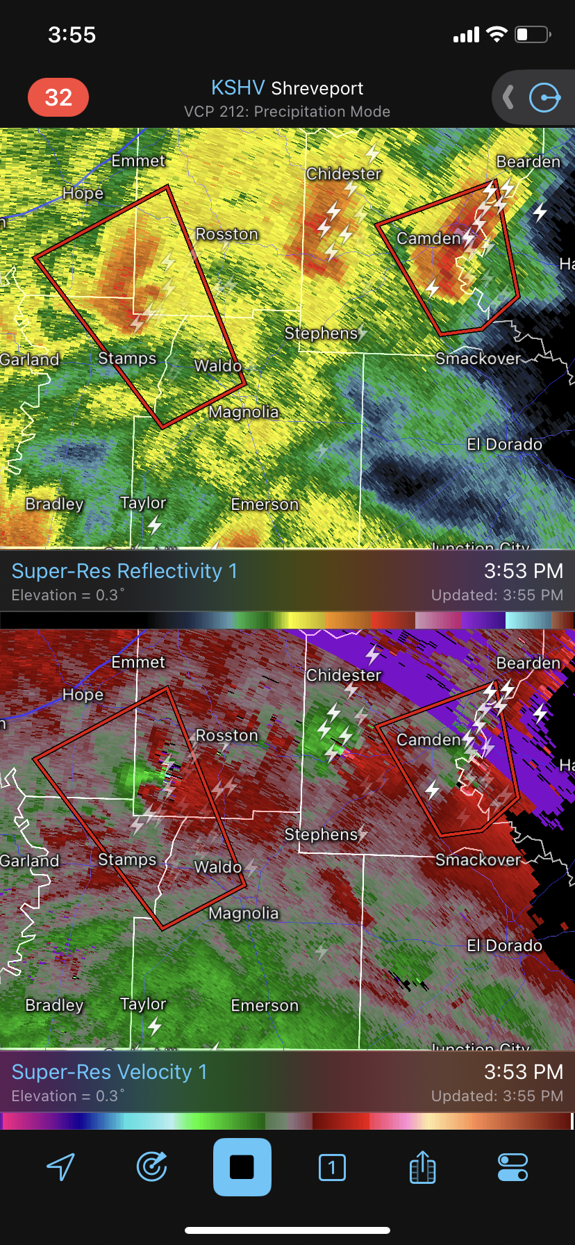
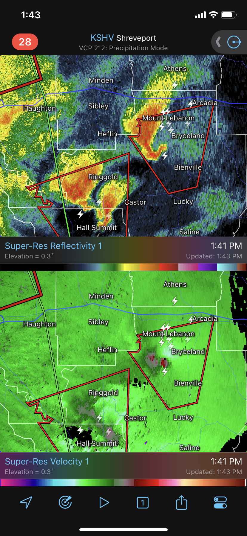
Tornado outbreak occurring in N LA and Texas.
-
I think the upper dynamics are so incredible that’s it’s basically turning this system into an inland hurricane. Family in Houston still can’t go outside because the winds are so strong