Normandy Ho
-
Posts
3,295 -
Joined
-
Last visited
Content Type
Profiles
Blogs
Forums
American Weather
Media Demo
Store
Gallery
Everything posted by Normandy Ho
-
Because it’s structurally never been that kind of storm. This has been a giant gyre based system that organized via curved bands and multiple rotating convective bursts. Every storm doesn’t take the CDO path with the eye popping out. It’s not even physically possible with a core this size (the eye is 55 miles wide for example)
-
The taking off jokes were funny this morning but Helene is about to make y’all look hella stupid lol
-
Love this answer from eric
-
Good shit tomorrow is going to be an absolute shit show god speed to the mods.
-
This is why it’s generational. The 25 miles is only because it’s a minimal hurricane. As it starts cranking tomorrow the 25 is going to become 75 and up. Only comps I have are Katrina and Ike.
-
This is an absolutely generational hurricane heading towards Florida. The surge from this will be outrageous, and the inland wind will be astonishing due to fast movement. Incredible satellite presentation
-
2024 Atlantic Hurricane Season
Normandy Ho replied to Stormchaserchuck1's topic in Tropical Headquarters
Indeed brother. Everybody buckle up because October is about to be wild. GFS has the Caribbean cranking -
Top of the morning folks. We definitely got a rapidly intensifying cyclone (and a gigantic one at that the windfield is huge). Seems like my initial just north of Tampa call is going to be too far east, but man the intensity call is right on. This one is gonna smack the panhandle hard and the large size of it might bring big winds well Inland into Georgia. Enjoy tracking this one everyone
-
Monster convective burst occurring now. Get your coffee ready folks tonight is going to be fun
-
Both things can be true: that is the COC and it’s still embedded within the larger gyre. I think this will stall for a bit then start creeping north before again turning wnw later today
-
Indeed that is the meso that makes this Helene. And with what hurricane John has done I am going extremely high for intensity. Cat 4 still just north of Tampa is my call
-
Going full on Otis. Needs to get inland right now
-
It seems as if the soon to be intense hurricane John (start paying attention now to the EPaC thread that thing is cranking) is pushing genesis for future Helene further east. Interested to see morning model runs but I’m starting to like a just north of tampa solution
-
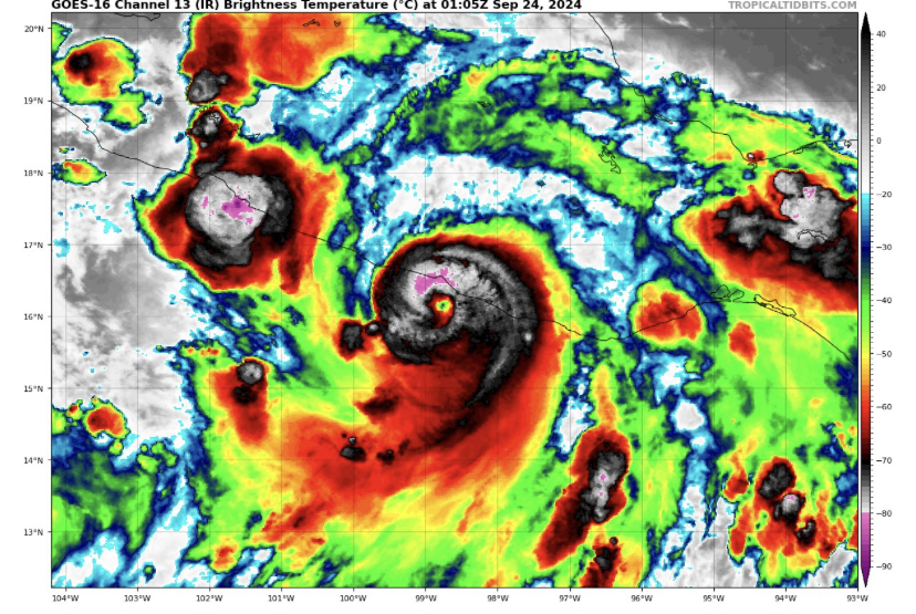
@Windspeed no doubt, last night when I saw that convection pinwheeling I thought this one is something different. Now we have an eye about to pop. They need hurricane warnings for mexico. Major Otis vibes with this
-
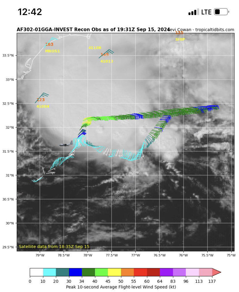
This looks a bit stronger than 35 knots. When are they sending recon?
-
Starting to get a big westerly wind surge coming off Nicaragua. Gyre is starting to crank now
-
2024 Atlantic Hurricane Season
Normandy Ho replied to Stormchaserchuck1's topic in Tropical Headquarters
GFS is a goddam mess. No consistency (and I’m not faulting the model it’s just output is chaotic which might be indicative of the pattern). -
Potential Tropical Cyclone Eight—50mph/1006mb
Normandy Ho replied to WxWatcher007's topic in Tropical Headquarters
I hear that. I guess I just figure pull the trigger since it’s obvious it will eventually become a TC (get ahead of warnings since you have to write an advisory anyway) -
Potential Tropical Cyclone Eight—50mph/1006mb
Normandy Ho replied to WxWatcher007's topic in Tropical Headquarters
A PTC? Come on NHC be better -
Potential Tropical Cyclone Eight—50mph/1006mb
Normandy Ho replied to WxWatcher007's topic in Tropical Headquarters
Upgrade is imminent
-
Potential Tropical Cyclone Eight—50mph/1006mb
Normandy Ho replied to WxWatcher007's topic in Tropical Headquarters
The MCV of the coast to me looks to be the catalyst. The further it slides east the more time over water this would get -
2024 Atlantic Hurricane Season
Normandy Ho replied to Stormchaserchuck1's topic in Tropical Headquarters
Disagree on 94L. This should have already been a TC -
Current motion def brings this over NO. Sliding way east now
-
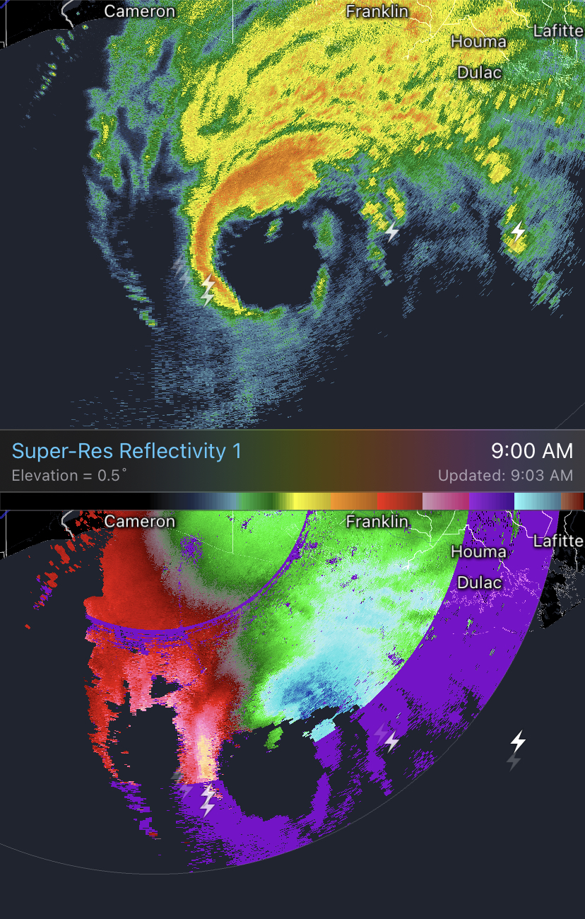
Excellent radar presentation. Almost looks like a giant right moving supercell with a hook echo. Velocities are also very strong around the core. Seems to be ramping up in the face of shear

-
For sure. There is still a broad gyre but that center is tight enough that I think it becomes dominant.