Normandy
-
Posts
749 -
Joined
-
Last visited
Content Type
Profiles
Blogs
Forums
American Weather
Media Demo
Store
Gallery
Everything posted by Normandy
-
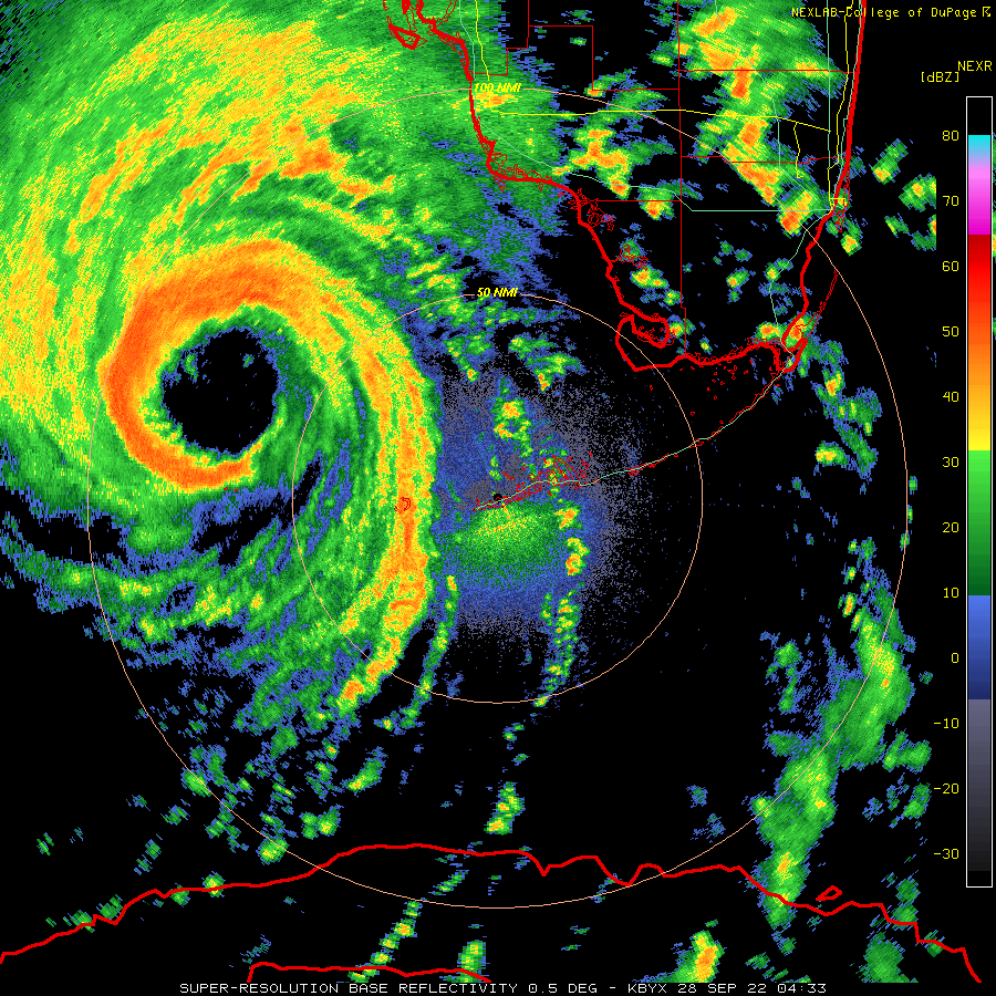
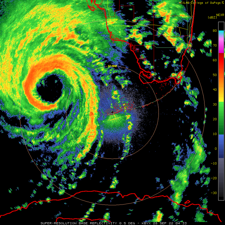
Unreal intensification going on right now
-
I am guessing by the flight pattern recon wants to taste that new convective burst.
-
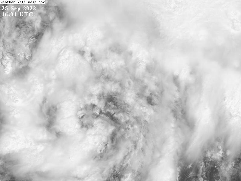
Excellent Radar presentation. Satellite presentation will follow soon.
-
The trough interaction has made this an absolute monster of a storm. This one will be the benchmark strike for SW FL.
-
The monster hot tower being ejected wnw south of the eye is absolutely wild to see. Monster hot tower on the west side. Insane trough interaction creating a wild outflow jet to the north. The Freak show is about to start I think.
-
2022 Atlantic Hurricane season
Normandy replied to StormchaserChuck!'s topic in Tropical Headquarters
The season is not over. I don’t know how else to illustrate to people this point. It’s maddening -
2022 Atlantic Hurricane season
Normandy replied to StormchaserChuck!'s topic in Tropical Headquarters
Season already has been disastrous. Members who still talk about seasonal busts should be 5-posted instantly. -
Seeing this continually slide NNE-NE and constantly be on the right hand side of the guidance even after said guidance corrects east is very unnerving.
-
Excellent call by the NHC. Nuclear core development going on right now.
-
I see a deep trough that is digging and a rapidly intensifying hurricane directly to its south. I am having a hard time seeing this getting further west.
-
Ian is cranking right now....might be taking advantage of some land interaction tightening the circulation up. For the first time in its life deep convection surrounds the eye.
-
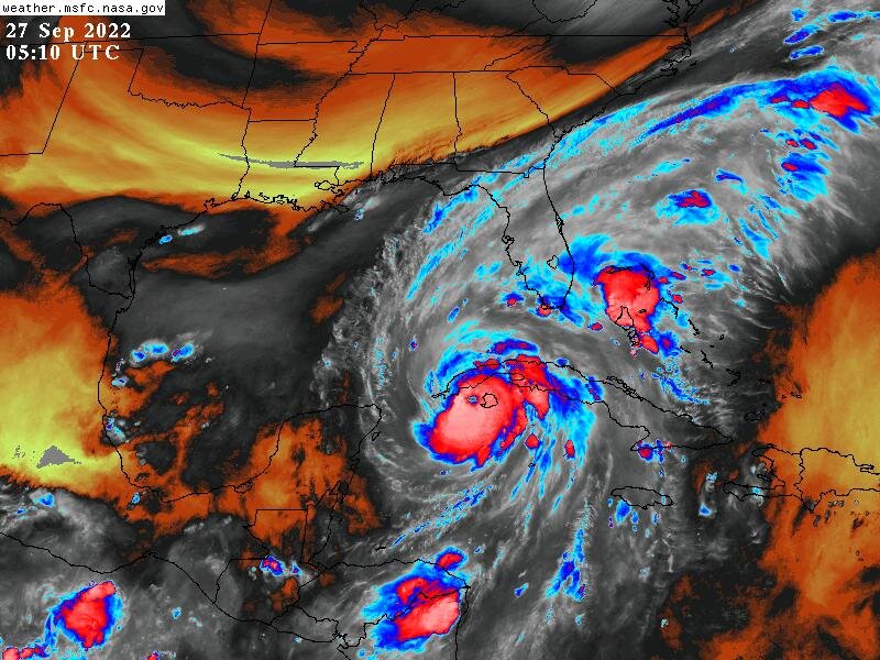
Latest Euro is a punishing strike to the West Coast of Florida. Lots of wind, surge, and flooding damage.
-
Hurricane Ian landfall location/intensity prediction thread
Normandy replied to Hoosier's topic in Tropical Headquarters
Torch Tiger is going to win. Never even considered picking the keys -
Here come the east shifts.......Knew it was coming. Its the same thing that happens to storms that are recurving off the east coast....they always trend east.
-
Hurricane Ian landfall location/intensity prediction thread
Normandy replied to Hoosier's topic in Tropical Headquarters
Port charlotte. 150 mph -
Hurricane Ian landfall location/intensity prediction thread
Normandy replied to Hoosier's topic in Tropical Headquarters
South of Tampa, north of fort myers. 150 mph. -
Not THAT gutsy. When I say just south, I'm basically saying the eye could go over Tampa considering angle of approach. I'm more of the belief the trough tugs this further east than being modeled (and kind of being verified right now in real time as its a bit east of the forecast track). Even a further south solution is not a large track error (50 miles means much more in this case than typical 90 degree approach).
-
This is as dicey of a situation as you can get for Tampa. I still think it comes in just south but Jesus its gonna be close.
-
Windfield is greatly expanded with a second wind maxima already detected
-
I am watching that giant curved band on the north side very closely. Lots of motion in those cells suggesting that we might have large core developing.
-
Oh yeah i'm firing up the IPAs and getting ready for a show tonight. Ian going nuts
-
Going to be a hectic day in Tampa tomorrow. HOT HOT towers rotating around the center now.
-
I am note sure what is legend or lore of Tampa avoid hurricanes.....but the only way Tampa avoids this hurricane is a miss to the south. Not gonna go far enough west to avoid the peninsula.
-
The Isle of Youth is a good benchmark for which part of the Peninsula deals with this I think. Any track west means Tampa and north. Any track over or east means SE/SW FL. Still not sold on Panhandle whatsoever (and GFS seems to moving away from that idea also).
-
GFS is slowly coming to the party. Ian is also starting to crank a little with a nice curved band structure evident.