

Eskimo Joe
-
Posts
24,733 -
Joined
-
Last visited
Content Type
Profiles
Blogs
Forums
American Weather
Media Demo
Store
Gallery
Everything posted by Eskimo Joe
-

2021 Mid-Atlantic Severe Weather - General Discussion
Eskimo Joe replied to Kmlwx's topic in Mid Atlantic
Looks like the warm sector with Fred's remnants is producing. Already two reported tornados and the supercell composite along the GA/SC border is pushing 8. -
Big breaks in the clouds now in Reisterstown. Actually seeing thinning of the mid level cloud deck.
-
Looks like a possible training event setting up over Baltimore City into Towson and then east to White Marsh. I gotta give credit to LWX, they've been money on these flash flood watches of late.
-
Yea last few frames of the visible showing some decent clearing even back to I-81 now. This is being confirmed by some of the ASOS station showing the ceiling jumping up over the past ~30 min.
-
Flash Flood Watch for coastal bay counties through 6pm this evening. LWX mentioned the convergence zone in causing this in their AFD update.
-
Visible satellite suggests areas along and east of I-95 could see sun today. Might help destabilize the atmosphere a bit more.
-
2021 Mid-Atlantic Severe Weather - General Discussion
Eskimo Joe replied to Kmlwx's topic in Mid Atlantic
Tomorrow screams surprise severe -
Not banter so not putting it there, but former TWC met dead:
-
M0.59" Reisterstown. I'm right by the PBS station off Owings Mills Blvd.
-
Frederick County, MD about to get flooded out.
-
If you want a quick setup, I recommend the Tempest from WxFlow
-
2021 Atlantic Hurricane Season Tracking Thread
Eskimo Joe replied to WxWatcher007's topic in Mid Atlantic
Looks like 12z Euro brings the 850 low with Fred through HGR. Would be a Wednesday afternoon to evening issue, actually looks like the brunt of the remnants come through during prime heating. -
Rekt
-
2021 Mid-Atlantic Severe Weather - General Discussion
Eskimo Joe replied to Kmlwx's topic in Mid Atlantic
IMO, SPC is smart to not highlight at D3 for this area. A subtle shift of 50 miles in the track is a big deal for downstream impacts. For the next couple of days, I would argue it's worthwhile to look upstream at these items: 1.) Location of flooding and heavy rain versus the forecast placement. 2.) Location of severe weather, tornadic activity in particular, versus the forecast placement. 3.) Overall expanse of the warm sector and whether it's dirty or big breaks in the clouds. 4.) Speed of the system. -
2021 Mid-Atlantic Severe Weather - General Discussion
Eskimo Joe replied to Kmlwx's topic in Mid Atlantic
Wednesday could be a sneaky overperforming event for us. -
2021 Mid-Atlantic Severe Weather - General Discussion
Eskimo Joe replied to Kmlwx's topic in Mid Atlantic
Yes. Was expecting Fred to be further west of where it is now. Could be a conditional tornado risk Wed into Thursday. -
2021 Mid-Atlantic Severe Weather - General Discussion
Eskimo Joe replied to Kmlwx's topic in Mid Atlantic
Got a screenshot of what it looks like? -
Bring it
-
Mowed the lawn...lost a good 10lbs of body weight in sweat.
-
2021 Atlantic Hurricane Season Tracking Thread
Eskimo Joe replied to WxWatcher007's topic in Mid Atlantic
Maybe this will be our year -
Significant uptick in CG for storms west of Charles Town and Martinsburg. Might be the "storm of the day" trying to form there.
-
IAD at 95 and FDK at 97. Probably pre-frontal winds and touch of downsloping aiding in the spike.
-
Would argue that given the meso disco out, even though it's only 40% watch probability, that we get upgraded to a slight risk with the afternoon update.
-
2021 Mid-Atlantic Severe Weather - General Discussion
Eskimo Joe replied to Kmlwx's topic in Mid Atlantic
Something to add to your knowledge base: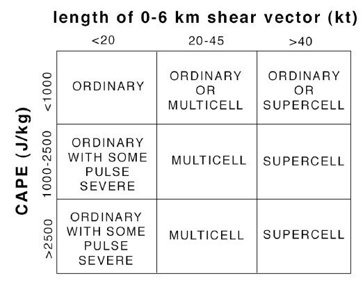
-
I ran a history of all Excessive Heat Advisories through the iembot. I don't have the time to view the results, but here's a KML file you can pop into Google maps/earth to see what the density is: sbw_interval.kml


