

Itstrainingtime
-
Posts
19,655 -
Joined
-
Last visited
Content Type
Profiles
Blogs
Forums
American Weather
Media Demo
Store
Gallery
Posts posted by Itstrainingtime
-
-
3 hours ago, Itstrainingtime said:
For those of us down south - radar is kind of meh so far. The cells down in MD/VA/WV are weakening as the entire area moves east. Not a lot showing up that would be targeting our area.
Still time for change.
@Blizzard of 93 - read my last sentence.
-
 2
2
-
-
For those of us down south - radar is kind of meh so far. The cells down in MD/VA/WV are weakening as the entire area moves east. Not a lot showing up that would be targeting our area.
Still time for change.
-
18 minutes ago, canderson said:
Going to go on a limb and say CTP today will set a record for most TOR warnings they've ever issued in one day.
Have to think that in my lifetime (1965 onward) that the record had to be set on 5/30/1985. I've found a lot of information but not the number of warnings that came from our local office. Many of the warnings that day were issued by Pittsburgh and Cleveland as well.
I will never forget that event.
-
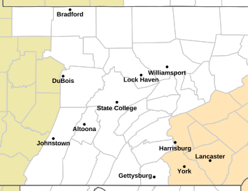
There are now 5 active TOR warnings that have been issued by Cleveland, State College and Binghamton.
-
1
-
-
Tornado Warning PAC105-101745- /O.NEW.KCTP.TO.W.0007.240710T1726Z-240710T1745Z/ BULLETIN - EAS ACTIVATION REQUESTED Tornado Warning National Weather Service State College PA 126 PM EDT Wed Jul 10 2024 The National Weather Service in State College PA has issued a * Tornado Warning for... Northwestern Potter County in north central Pennsylvania... * Until 145 PM EDT. * At 126 PM EDT, a severe thunderstorm capable of producing a tornado was located near Shinglehouse, moving northeast at 40 mph. HAZARD...Tornado. SOURCE...Radar indicated rotation. IMPACT...Flying debris will be dangerous to those caught without shelter. Mobile homes will be damaged or destroyed. Damage to roofs, windows, and vehicles will occur. Tree damage is likely. * This dangerous storm will be near... Genesee around 140 PM EDT. Other locations impacted by this tornadic thunderstorm include Oswayo. PRECAUTIONARY/PREPAREDNESS ACTIONS... TAKE COVER NOW! Move to a basement or an interior room on the lowest floor of a sturdy building. Avoid windows. If you are outdoors, in a mobile home, or in a vehicle, move to the closest substantial shelter and protect yourself from flying debris. && LAT...LON 4200 7775 4189 7803 4188 7812 4192 7815 4200 7806 TIME...MOT...LOC 1726Z 233DEG 35KT 4194 7805 TORNADO...RADAR INDICATED MAX HAIL SIZE...<.75 IN $$ Colbert -
7 minutes ago, Atomixwx said:
It's raining. I haven't seen rain in two weeks.
What's it look like? What does it do when it falls?
-
 2
2
-
-
-
40 minutes ago, mahantango#1 said:
Is your mower starting to rust away?
It's getting rusty, though not as rusty as my snow shovel, which I haven't used for 3 consecutive winters.
39 minutes ago, Atomixwx said:He didn't mention it, but it committed suicide. Lawnmowers have an immense suicide rate and when the reality hits them that they no longer serve a purpose, it's over.
As long as it's been since I used it, might very well be dead.
36 minutes ago, mahantango#1 said:I wonder if he's burying it in his backyard?
Right beside my wif...whiffle ball bat.
33 minutes ago, Bubbler86 said:I think I remember him mowing a lot during 2019-2022 where MDT had 32-35 ninety or higher days every one of those years. MDT is running slightly behind all these years as of now but may catch up by mid-week next week. The convection lottery has been terrible to some of the Lanco folks as well as Canderson.

I've mowed a lot every year for years. Since I was handed over the responsibility from my dad when I was 4. Big difference this year...it ain't raining. This seems unprecedented to me. It's not uncommon for it to really die out later in July and especially into August, but my yard has been toast for weeks now. Hot and water = mowing, hot and dry = itsnotmowingtimeanymore.
-
3
-
-
90 in Maytown. 17th day this year at or above that mark. Already passed last year's total.
-
1
-
-
2 minutes ago, canderson said:
As expected, SPC has upgraded S and C NY state into Enhanced and moved the SLIGHT all the way down through central PA and the LSV into Maryland and down a bit into N VA. They don't have the enhanced along the northern tier which I am a bit surprised by, but with a 5 percent TOR hatch maybe it's semantics.

-
1
-
 1
1
-
-
Big-time reduction in expected rainfall continues - sigh:

-
Currently it's sun through high cloudiness and 85.7. MU says tomorrow we see a 10-15 degree drop in dewpoints. Bring it.
-
1
-
1
-
-
Lowest temp overnight was 79.3.
Really hope that everyone up north stays safe today. Ominous to see some posters in here who are known to post only when prolific severe weather is about to unfold, and that's usually down south or out in the midwest.
-
7 minutes ago, Jns2183 said:
The field next to you?
Sent from my SM-G970U using Tapatalk
The far end had a trace.
")
-
1 hour ago, Bubbler86 said:
Some 1-2" totals.
Not even a dusting here.
-
1
-
-
31 minutes ago, Voyager said:
Anyone see State College's Facebook post? Storms and possible tornados tomorrow evening.
Met from MU had a lot to say about this earlier today. To echo what @candersonsaid, he expects a big threat north of I80, much smaller risk between 80 and 76, virtually no threat down this way.
-
Well...I just had Mrs. HR review the new plate. Her response to me:
"What the F*** is wrong with you?"
-
5
-
-
I'll say it.
I've always thought our state's license plate was a little...generic. Non-descript. Maybe even...boring.
I like the new plate.
-
1
-
-
96 was the high today in Maytown. Clouds likely shaved 1-3 degrees off what it might have gotten to. Still - 9th day of 95 or higher.
-
92/73 at 3:50pm.
-
Another cell just formed - my wife says she can see it raining across the fields from our house. She said "we're missing it by a half mile." It's moving away from us.
All I can do is LOL.
-
1
-
-
34 minutes ago, Bubbler86 said:
Cells forming in Lanco. Clouded up here and 90.
Yep...how sweet it is watching them blow up 10 miles to my east!
-
 1
1
-
-
4 hours ago, Itstrainingtime said:
Holy Bazooka bubble gums, it is downright nasty outside. Just walked across campus...good lord is it stifling.
75 was my overnight "low" - currently it's 86 in Maytown at 9:05am.
17 minutes ago, Bubbler86 said:I know some people that leave their AC at 85 during the summer so 94/73 is nothing to them, while someone who stays in cooler AC all the time will think it is horrible. The great mysteries of assumptive HI values.
Hmmm...
-
2
-
-
1 minute ago, Bubbler86 said:
First 12Z Global keeping hopes alive for easters

Interesting how the heaviest rain "fills in" the southern Chessy Bay almost perfectly.
-
1
-
Central Pa. Summer 2024
in Upstate New York/Pennsylvania
Posted
My fear, and to @paweather point, is that the line is progressing so slowly eastbound that by the time it reaches here...