EastonSN+
-
Posts
8,666 -
Joined
-
Last visited
Content Type
Profiles
Blogs
Forums
American Weather
Media Demo
Store
Gallery
Everything posted by EastonSN+
-

Extreme Cold, Snow & Sleet: SECS 1/24 - 1/26
EastonSN+ replied to TriPol's topic in New York City Metro
Still means they are going for 12 in CPK, but yeah for surrounding areas. -
Extreme Cold, Snow & Sleet: SECS 1/24 - 1/26
EastonSN+ replied to TriPol's topic in New York City Metro
It may have been 93. I was pushing karts at a supermarket called stew Leonards and was absolutely frozen in the morning. -
Extreme Cold, Snow & Sleet: SECS 1/24 - 1/26
EastonSN+ replied to TriPol's topic in New York City Metro
I have noticed that they tend to air on the side of caution and lean towards the worst case. Better to prepare people for the worst and bust high than the other way around. -
Extreme Cold, Snow & Sleet: SECS 1/24 - 1/26
EastonSN+ replied to TriPol's topic in New York City Metro
Updated Upton map.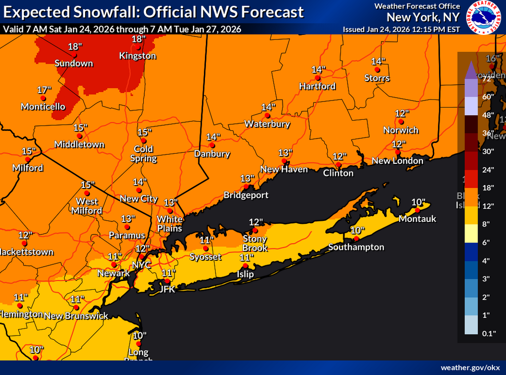
-
Extreme Cold, Snow & Sleet: SECS 1/24 - 1/26
EastonSN+ replied to TriPol's topic in New York City Metro
There were a few storms over the 80s as well where we had an arctic airmass in place and quickly changed to sleet. Have not seen something like this since the early 90s. -
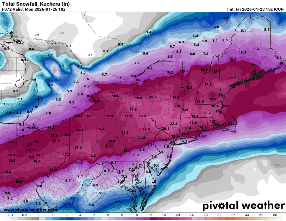
New York City 5.9 Boston 18 Philadelphia 5.1 Washington DC 4.8 Hartford 14 Albany 13
-
Extreme Cold, Snow & Sleet: SECS 1/24 - 1/26
EastonSN+ replied to TriPol's topic in New York City Metro
Thanks Don. I am starting to lean towards the lower end given the guidance. You may have the date, however, it was either january 1993 or 1994 (the cold and icy winter) which had a similar setup to this. Believe the city was 5 degrees in the morning and within 5 or 6 hours flipped to sleet (i do not recall the exact amount that fell). Boston was all snow and received over a foot. This setup and cold air in place seems like a carbon copy. Perhaps can be used as a guide on thos event. -
Horrible trends for us today. One more bump and its sleets to Boston (a possibility at this point). Bad mood so... . Tomorrow disappointment 4 to 8 and a lot of sleet. Cold and dry for 7 days. Warm up and rain from a coastal hugger with a stale airmass. SSWE fails and everyone blames GW and says in 1900 we would have had 150 inches in the same setup.
-
January 2026 regional war/obs/disco thread
EastonSN+ replied to Baroclinic Zone's topic in New England
February 3rd has some signal. Could be a coastal hugger too. -
Thanks. I hope nothing worse than cold and dry
-
Extreme Cold, Snow & Sleet: SECS 1/24 - 1/26
EastonSN+ replied to TriPol's topic in New York City Metro
You were right on this one. Starting to think closer to 6 before the flip but will range 6 to 10 in case the initial thump is impressive. Is that what your thoughts are? -
Extreme Cold, Snow & Sleet: SECS 1/24 - 1/26
EastonSN+ replied to TriPol's topic in New York City Metro
Looked st the models this morning Going with 6 to 10 for CPK. Good news is the sleet will make the pack even stronger/last longer. -
Extreme Cold, Snow & Sleet: SECS 1/24 - 1/26
EastonSN+ replied to TriPol's topic in New York City Metro
Talk about no change run to run lol.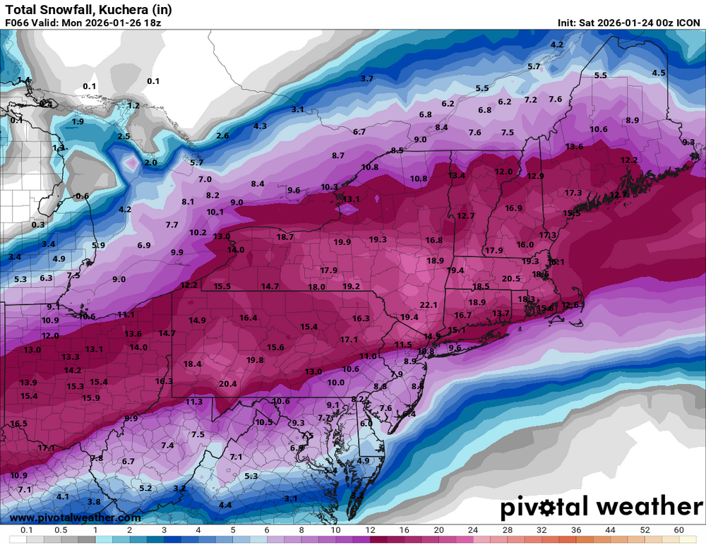
-
Extreme Cold, Snow & Sleet: SECS 1/24 - 1/26
EastonSN+ replied to TriPol's topic in New York City Metro
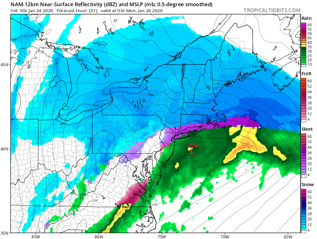
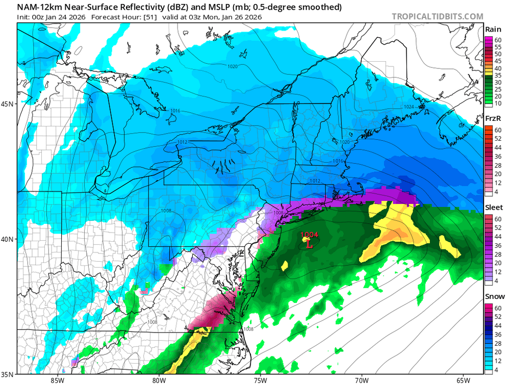
So the 12k flipped to sleet quicker but the sleet line did not get as far north which is a step in the right direction. We need 1 more tick like that. -
Extreme Cold, Snow & Sleet: SECS 1/24 - 1/26
EastonSN+ replied to TriPol's topic in New York City Metro
I believe central park had 7.5 inches before the thundersleet. Up here in CT had 9.5 before the thunder sleet -
Extreme Cold, Snow & Sleet: SECS 1/24 - 1/26
EastonSN+ replied to TriPol's topic in New York City Metro
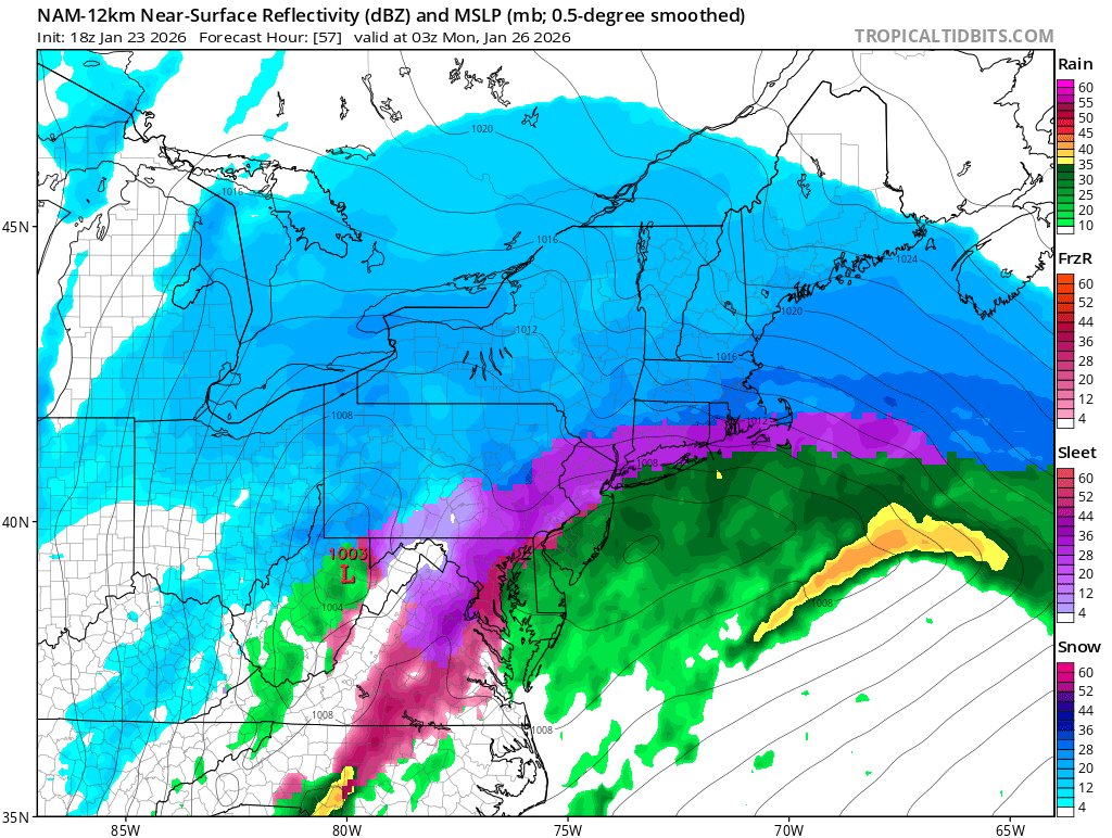
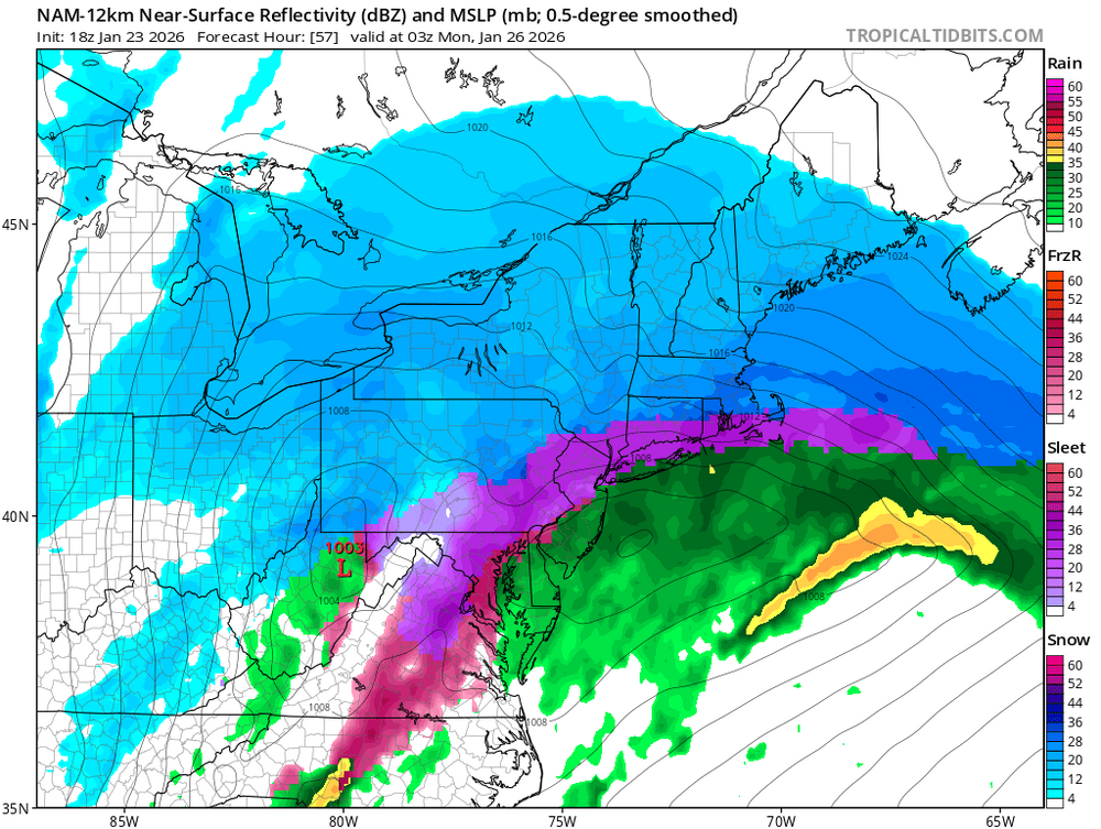
The NAM was a step in the right direction. -
Extreme Cold, Snow & Sleet: SECS 1/24 - 1/26
EastonSN+ replied to TriPol's topic in New York City Metro
-
Extreme Cold, Snow & Sleet: SECS 1/24 - 1/26
EastonSN+ replied to TriPol's topic in New York City Metro
The sleet does not get as far north as 18z. Sleet arrived a bit faster but did not go as far north. -
It actually increased in Philly too (the age old how much for Philly question).
-
Yeah they have the snowfall map in the MA forum and it looks like their snowfall increased this run.
-
Extreme Cold, Snow & Sleet: SECS 1/24 - 1/26
EastonSN+ replied to TriPol's topic in New York City Metro
Would happen to have 12z? Hate 10 to 1 miss represents southern areas. -
Extreme Cold, Snow & Sleet: SECS 1/24 - 1/26
EastonSN+ replied to TriPol's topic in New York City Metro
Updated. Better: GFS RGEM HRDPS Worse: NAM RRFS ICON Held: GFSAI -
Extreme Cold, Snow & Sleet: SECS 1/24 - 1/26
EastonSN+ replied to TriPol's topic in New York City Metro
Better: GFS RGEM Worse: NAM ICON Held: GFSAI -
Extreme Cold, Snow & Sleet: SECS 1/24 - 1/26
EastonSN+ replied to TriPol's topic in New York City Metro
The continued big improvement was how the western side gets compressed and shoved east before the primary can gain too much latitude. -
Extreme Cold, Snow & Sleet: SECS 1/24 - 1/26
EastonSN+ replied to TriPol's topic in New York City Metro
GFS ticked better!! Better: GFS RGEM Worse: NAM ICON.