

2010 extreme
-
Posts
217 -
Joined
-
Last visited
Content Type
Profiles
Blogs
Forums
American Weather
Media Demo
Store
Gallery
Everything posted by 2010 extreme
-
MN, do you have any records of your high temperature on Friday, July 19 2019 and possibly what time it occurred? I'm trying to compare obs in Nova from today vs that day. If so, it's much appreciated.
-
It's much drier today than five years ago when I 270 flooded badly.
-
2022 Mid-Atlantic Severe Wx Thread (General Discussion Etc)
2010 extreme replied to Kmlwx's topic in Mid Atlantic
Very true and unlike coastal snow, severe events, particularly large-scale ones tend to trend south and east. This looks no different as earlier times are now favored. However, large scale off season high shear low cape events which normally fail to gusty showers end up being our most impressive outbreaks when they do perform. Probably won't happen this time as the period from early October to early November have never really seen much. -
2022 Mid-Atlantic Severe Wx Thread (General Discussion Etc)
2010 extreme replied to Kmlwx's topic in Mid Atlantic
ZCZC SPCSWOD48 ALL ACUS48 KWNS 090805 SPC AC 090805 Day 4-8 Convective Outlook NWS Storm Prediction Center Norman OK 0305 AM CDT Sun Oct 09 2022 Valid 121200Z - 171200Z ...DISCUSSION... ...Wednesday/Day 4 and Thursday/Day 5... A cold front is forecast to move quickly eastward across the western Great Lakes and mid Mississippi Valley on Wednesday. This will occur ahead of a substantial upper-level trough that is forecast to deepen during the day. Due to strong forcing associated with the upper-level trough and cold front, a line of thunderstorms will likely develop Wednesday afternoon. This line of storms should move eastward across the southern Great Lakes and Ohio Valley Wednesday afternoon. Although a wind-damage threat will be possible along the leading edge of this line, limited moisture return and weak instability will be problematic for a more widespread threat. An isolated wind-damage threat could continue into the evening as the cold front and line of storms moves into the central Appalachians. The cold front is forecast to move through the Northeast on Thursday, and could reintensify by midday from parts of New York and Pennsylvania southward into the Mid Atlantic. The wind-damage threat could affect areas as far north as New England Thursday afternoon. A 15 percent contour could be needed in either Day 4 or Day 5, once the details become more clear in model runs that come out over the next day or two. -
Snow in late October can be a death sentence. 10/29/2011
-
I'm in the place I like viewing this time of night. Just south of the storm for a nice light show.
-
Winter 2021-2022 Digital Snow Thread
2010 extreme replied to NorthArlington101's topic in Mid Atlantic
Ice on top of snow let's do it. -
I'm glad I didn't see this post at work. It would have made me too hungary to be productive.
-
Winter 2021-2022 Digital Snow Thread
2010 extreme replied to NorthArlington101's topic in Mid Atlantic
Early season clipper anyone? Just 10 days out. -
Interesting, that's how it's happened the past two years. Cold NW flow in mid November.
-
BWI: 10/29 IAD : 10/22 DCA: 11/12 RIC: 10/30 Tie: 1.2"
-
2021 Mid-Atlantic Severe Weather - General Discussion
2010 extreme replied to Kmlwx's topic in Mid Atlantic
Looks like the morning rain messed up todays chances. -
It was 20years ago College Park and N va outbreak occurred. What a interesting day that was.
-
Interesting, never seen a wind advisory two counties wide that has no ridge along its axis and it only last for 4 hours. Potomac River wind tunnel/channel from 2-6 pm tomorrow.
-
2020 Mid-Atlantic Severe Weather - General Thread
2010 extreme replied to Kmlwx's topic in Mid Atlantic
Have strong gusts here. -
December 8-10, 2018 Winter Storm
2010 extreme replied to Orangeburgwx's topic in Southeastern States
Just came here cause I have family in the southeast affected by this storm but looks like I visited here at the wrong time. Anyways looks like the Charlotte area will be close between snow and sleet. -
I was driving and never felt it.
-
It was at this time mid night sunday morning walking north on my street in nearly knee deep snow I could see clear sky to my west and and a definitave back edge of the clouds looking east as the last flurries were flying. It was a spectacular end to the storm.
-
It was at this time friday evening snow had started to overspread much of the area.
-
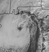
That storm was a nearly perfect miller a for ma, very similar to Feb 1983. The storm already had an eye and tons of moisture ahead of it before before it made land fall in western Florida! I was supposed to work from 10am to 6pm that day which was the time the worst would be. Im glad I called out even they were pressuring me to come in that morning because by the evening there was a solid 18-22 inch wall of snow between the main road and my street. Since I drive a corolla that would have been a disaster.
