Spartman
-
Posts
1,219 -
Joined
-
Last visited
Content Type
Profiles
Blogs
Forums
American Weather
Media Demo
Store
Gallery
Everything posted by Spartman
-
VEI-6 eruptions usually lead to noticeable short-term effects on the global climate. If this is the case, we can expect to see these effects during this Summer, just like in 1992. JB already talking about a cooler-than-normal summer for much of the US. Wonder if this could be when we start to see the effects of the Tonga eruption that occurred in January.
-
TWC just posted a video about this yesterday. The Tonga eruption reached well into the ionosphere a.k.a. space. https://weather.com/news/video/tonga-volcanic-eruption-biggest-explosion-ever-recorded-and-reached-space
-
Spring 2022 Medium/Long Range Discussion
Spartman replied to Chicago Storm's topic in Lakes/Ohio Valley
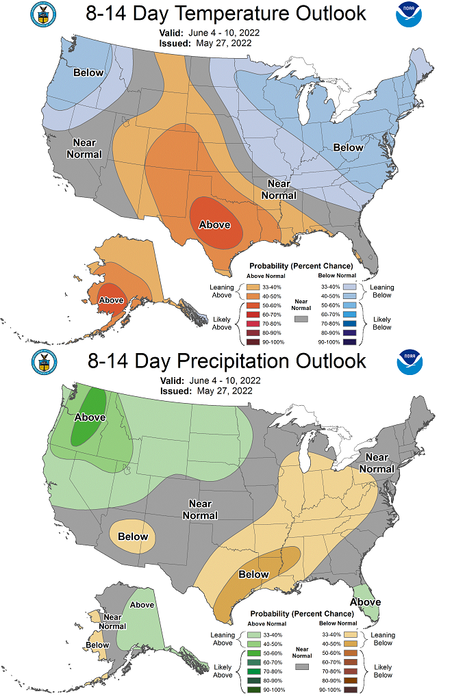
6-10 Day: 8-14 day: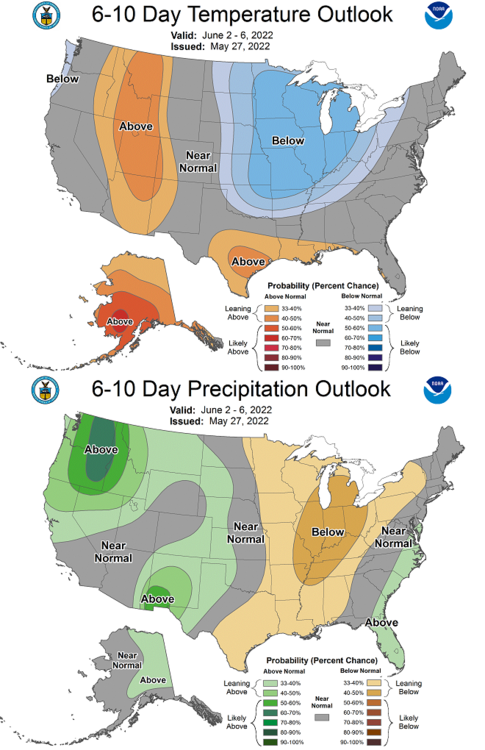

-
Spring 2022 Medium/Long Range Discussion
Spartman replied to Chicago Storm's topic in Lakes/Ohio Valley
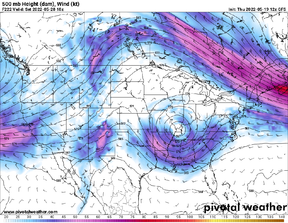
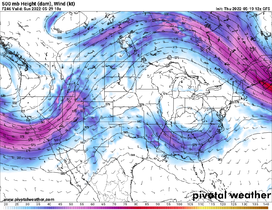
12z GFS hinting a cutoff low for Memorial Day weekend.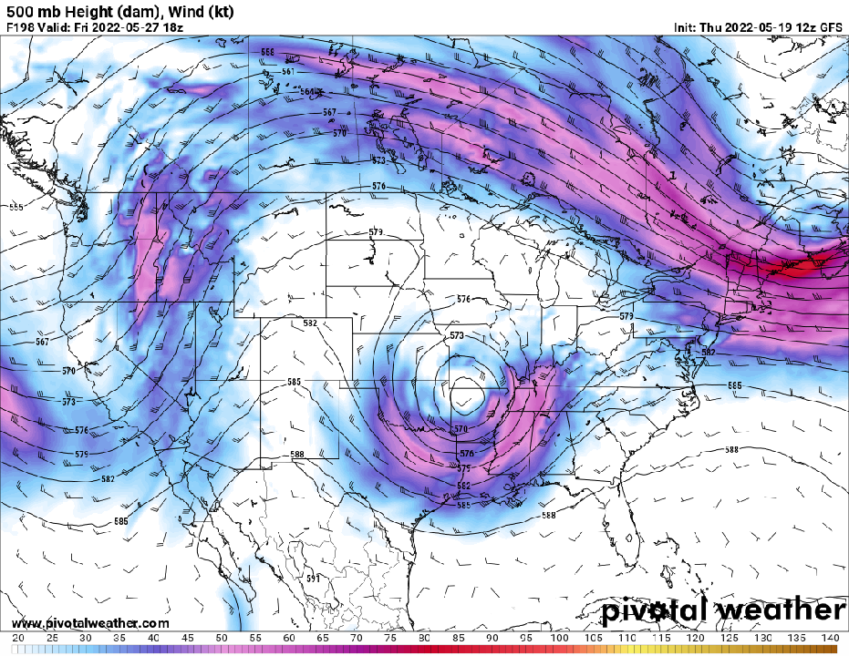
-
000 CXUS51 KILN 010540 CF6DAY PRELIMINARY LOCAL CLIMATOLOGICAL DATA (WS FORM: F-6) STATION: DAYTON OH MONTH: APRIL YEAR: 2022 LATITUDE: 39 54 N LONGITUDE: 84 12 W TEMPERATURE IN F: :PCPN: SNOW: WIND :SUNSHINE: SKY :PK WND ================================================================================ 1 2 3 4 5 6A 6B 7 8 9 10 11 12 13 14 15 16 17 18 12Z AVG MX 2MIN DY MAX MIN AVG DEP HDD CDD WTR SNW DPTH SPD SPD DIR MIN PSBL S-S WX SPD DR ================================================================================ 1 41 31 36 -12 29 0 0.02 0.4 T 11.6 25 300 M M 9 1 31 280 2 51 26 39 -9 26 0 0.02 0.0 0 9.3 29 270 M M 6 36 280 3 55 37 46 -3 19 0 0.00 0.0 0 9.8 29 280 M M 8 37 280 4 61 38 50 1 15 0 0.12 0.0 0 9.5 18 210 M M 7 1 23 220 5 58 39 49 -1 16 0 0.09 0.0 0 6.5 16 130 M M 9 12 19 140 6 57 42 50 0 15 0 0.15 0.0 0 9.9 24 280 M M 9 12 34 290 7 53 38 46 -4 19 0 0.01 0.0 0 13.8 29 240 M M 8 33 240 8 49 37 43 -8 22 0 0.03 0.0 0 11.4 26 250 M M 9 1 32 270 9 43 34 39 -12 26 0 0.15 0.1 0 12.7 26 290 M M 10 18 32 270 10 61 31 46 -6 19 0 0.00 0.0 0 8.9 18 140 M M 6 22 140 11 66 50 58 6 7 0 0.30 0.0 0 14.8 31 230 M M 10 1 39 220 12 70 49 60 8 5 0 0.13 0.0 0 10.1 20 170 M M 7 1 23 180 13 68 61 65 12 0 0 1.15 0.0 0 12.7 23 170 M M 9 13 35 160 14 62 40 51 -2 14 0 0.05 0.0 0 17.7 39 250 M M 5 1 47 250 15 71 46 59 5 6 0 0.01 0.0 0 17.8 35 230 M M 6 44 240 16 59 37 48 -6 17 0 0.10 0.0 0 13.5 32 230 M M 6 1 40 240 17 50 29 40 -14 25 0 0.00 0.0 0 9.7 17 40 M M 3 27 60 18 41 33 37 -18 28 0 0.31 2.3 T 12.9 25 300 M M 10 1248 32 300 19 50 34 42 -13 23 0 T T 0 13.3 26 290 M M 8 32 290 20 62 32 47 -9 18 0 0.00 0.0 0 11.5 22 130 M M 7 29 130 21 68 53 61 5 4 0 0.26 0.0 0 12.9 33 220 M M 8 18 46 230 22 75 46 61 5 4 0 0.00 0.0 0 7.9 16 140 M M 7 12 20 170 23 84 53 69 12 0 4 0.00 0.0 0 11.2 23 210 M M 3 28 210 24 82 66 74 17 0 9 0.00 0.0 0 14.6 25 220 M M 6 35 210 25 74 48 61 4 4 0 0.16 0.0 0 10.3 24 250 M M 8 1 31 220 26 51 37 44 -14 21 0 0.00 0.0 0 12.3 23 310 M M 6 27 310 27 57 33 45 -13 20 0 0.00 0.0 0 9.7 21 320 M M 2 26 300 28 57 39 48 -10 17 0 T 0.0 0 8.8 17 70 M M 9 22 50 29 66 48 57 -2 8 0 0.00 0.0 0 11.2 17 120 M M 10 20 110 30 67 50 59 0 6 0 0.11 0.0 0 14.0 23 130 M M 10 3 30 130 ================================================================================ SM 1809 1237 433 13 3.17 2.8 350.3 M 221 ================================================================================ AV 60.3 41.2 11.7 FASTST M M 7 MAX(MPH) MISC ----> 39 250 47 250 ================================================================================ NOTES: # LAST OF SEVERAL OCCURRENCES COLUMN 17 PEAK WIND IN M.P.H. PRELIMINARY LOCAL CLIMATOLOGICAL DATA (WS FORM: F-6) , PAGE 2 STATION: DAYTON OH MONTH: APRIL YEAR: 2022 LATITUDE: 39 54 N LONGITUDE: 84 12 W [TEMPERATURE DATA] [PRECIPITATION DATA] SYMBOLS USED IN COLUMN 16 AVERAGE MONTHLY: 50.8 TOTAL FOR MONTH: 3.17 1 = FOG OR MIST DPTR FM NORMAL: -2.9 DPTR FM NORMAL: -1.29 2 = FOG REDUCING VISIBILITY HIGHEST: 84 ON 23 GRTST 24HR 1.20 ON 13-14 TO 1/4 MILE OR LESS LOWEST: 26 ON 2 3 = THUNDER SNOW, ICE PELLETS, HAIL 4 = ICE PELLETS TOTAL MONTH: 2.8 INCHES 5 = HAIL GRTST 24HR 2.3 ON 18-18 6 = FREEZING RAIN OR DRIZZLE GRTST DEPTH: T 7 = DUSTSTORM OR SANDSTORM: VSBY 1/2 MILE OR LESS 8 = SMOKE OR HAZE [NO. OF DAYS WITH] [WEATHER - DAYS WITH] 9 = BLOWING SNOW X = TORNADO MAX 32 OR BELOW: 0 0.01 INCH OR MORE: 18 MAX 90 OR ABOVE: 0 0.10 INCH OR MORE: 11 MIN 32 OR BELOW: 5 0.50 INCH OR MORE: 1 MIN 0 OR BELOW: 0 1.00 INCH OR MORE: 1 [HDD (BASE 65) ] TOTAL THIS MO. 433 CLEAR (SCALE 0-3) 2 DPTR FM NORMAL 79 PTCLDY (SCALE 4-7) 16 TOTAL FM JUL 1 4744 CLOUDY (SCALE 8-10) 12 DPTR FM NORMAL -266 [CDD (BASE 65) ] TOTAL THIS MO. 13 DPTR FM NORMAL -2 [PRESSURE DATA] TOTAL FM JAN 1 13 HIGHEST SLP 30.47 ON 22 DPTR FM NORMAL -4 LOWEST SLP 29.56 ON 13 [REMARKS] #FINAL-04-22# Despite many days with measurable precipitation and just a few days short of the April record, April ended CAD.
-
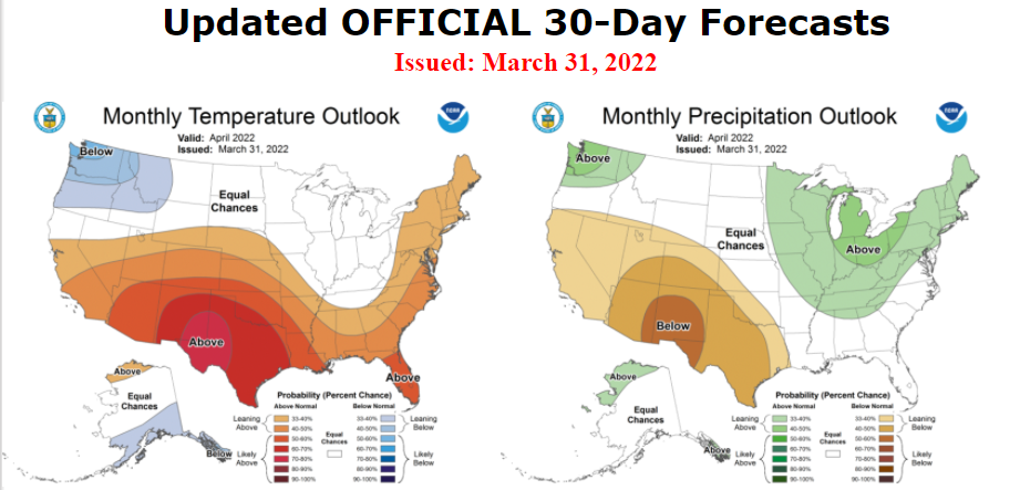
For at least the first week of May, we kick off the month with below-normal temperatures and consecutive days of rain.
-
It was nice to have a dry stretch this month that lasted more than only 1 day, especially when it includes a completely dry weekend. This is the second time to have a completely dry weekend this year.
-
Spring 2022 Medium/Long Range Discussion
Spartman replied to Chicago Storm's topic in Lakes/Ohio Valley
-
The first half of this month was just a washout. Only had 2 dry days the entire 1st half and so far this month. Today is the 14th day with measurable precipitation this month. The record number of days with measurable precipitation in April is 21 in 1920.
-
000 SXUS71 KILN 141347 RERDAY RECORD EVENT REPORT NATIONAL WEATHER SERVICE WILMINGTON OH 946 AM EDT THU APR 14 2022 ...RECORD DAILY MAXIMUM RAINFALL SET AT DAYTON OH... A RECORD RAINFALL OF 1.15 WAS SET AT DAYTON OH YESTERDAY. THIS BREAKS THE OLD RECORD OF 1.07 SET IN 1991. $$
-
Time to punt until May for the next day in the 70s.
-
Spring 2022 Medium/Long Range Discussion
Spartman replied to Chicago Storm's topic in Lakes/Ohio Valley
-
Got an inch of snow from that system.
-
-
Overcast every single day since Tuesday. Cloudiest stretch of the season.
-
Winter 2021-22 Short/Medium Range Discussion
Spartman replied to Chicago Storm's topic in Lakes/Ohio Valley
We may very well be returning back to a milder pattern towards the final week of this month. -
-
Overperforming and torching at 55 as of 2pm.
-
Since nobody else made this thread yet, I thought I'd make it.

-
Ended up with a nice, dry weekend yesterday. First dry weekend of 2022.
-
Hate it to end up being like the ice storm that New England and parts of Eastern Canada endured in January 1998.
-
-
Sounds like a lock now, thanks to the GooFuS.
-
Knowing how little snow we've had this season, time to lock in the GFS?