Spartman
-
Posts
1,219 -
Joined
-
Last visited
Content Type
Profiles
Blogs
Forums
American Weather
Media Demo
Store
Gallery
Everything posted by Spartman
-
Topped out at 92.
-
Temps really overperformed. Hit 91 at 4pm. First 90 of the year.
-
Only year Dayton didn't hit 90 until August was in 2008, which was the latest first on record. There had been only 3 years Dayton didn't hit 90 at all: 1958, 2000, and 2004. With the cicadas around, we might as well head towards a 2004 redux. We'd waste a hot pattern if we didn't tag 90 at all, just like a cold pattern in the Winter being wasted with very little snow. Even though BAMWX is hinting potential big heat late this month into early July, here's something from our coldmeister JB. JB is apparently hugging the Euro instead of the GooFuS this time.
-
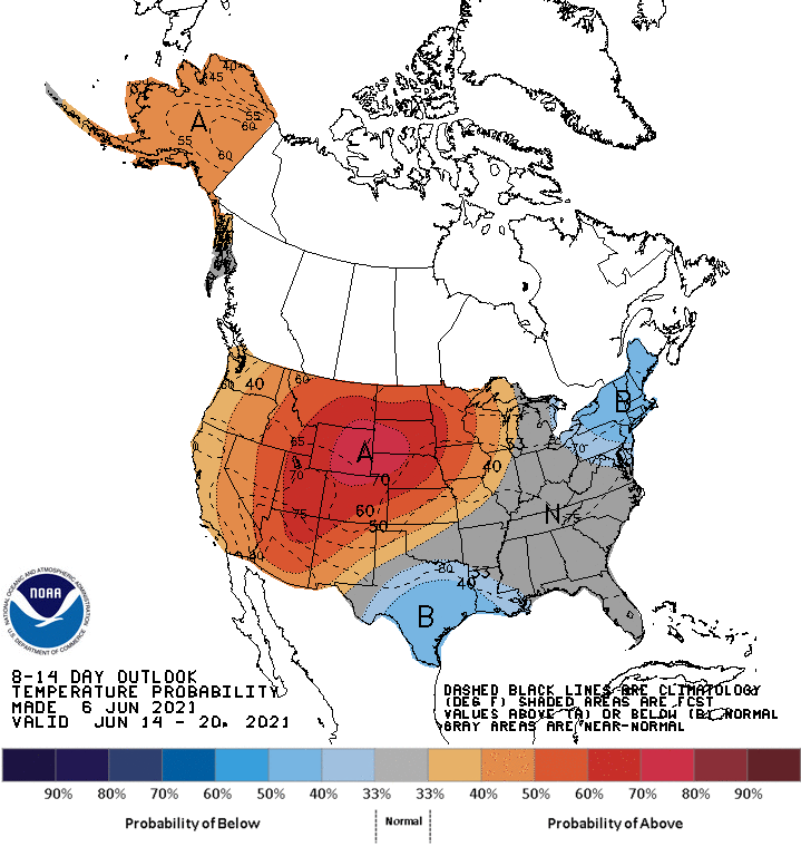
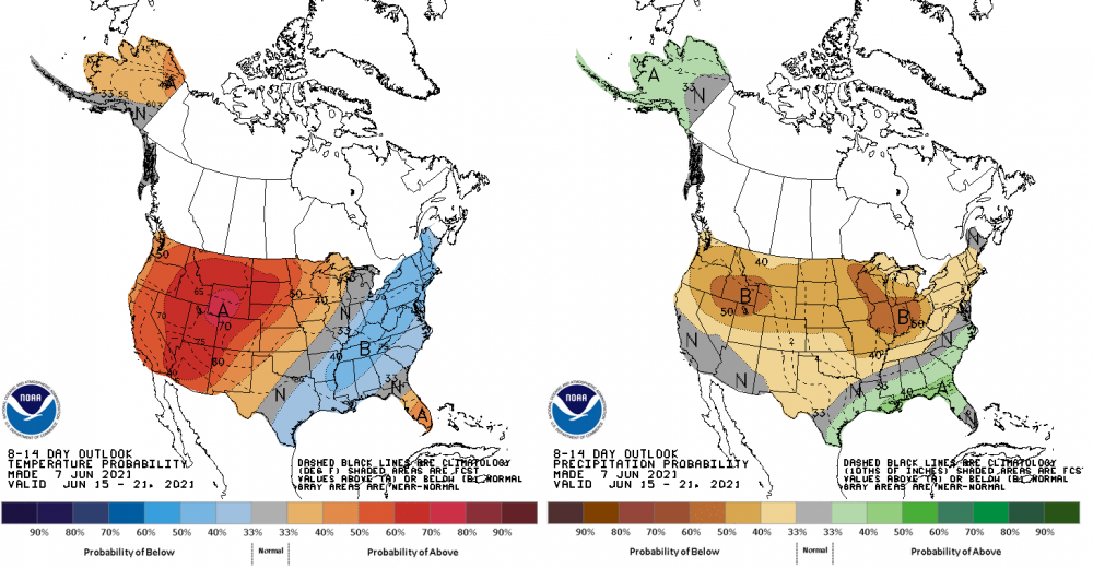
ZZZZZZZ 6-10 day: 8-14 day: BAMWX has something about beyond the 8-14 day outlook.
-
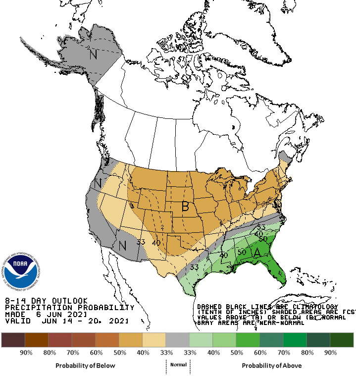
Starting to trend cool and dry on today's 8-14 day outlook.


-
July will be rockin'. Heck, DAY, CVG, and Indy all haven't even been 89'd yet this year and doesn't seem to look that way for the foreseeable future. Looks like this week and beyond are going to be a wash as we will be under the influence of a cutoff low that was responsible for the soaking rains over the past week down in Texas. The GooFuS is even hinting this for next weekend.
-
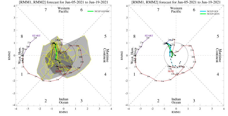
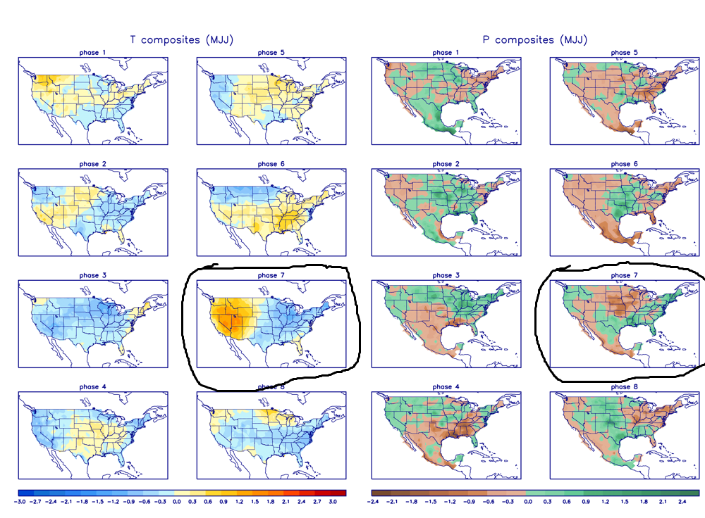
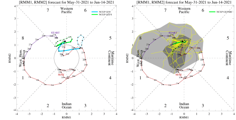
We're now in phase 7 of the MJO, but it's about to fall into the COD soon. For this time of the year, Phase 7 into the COD would mean cooler-than-normal temperatures and equal-chances for above-normal or below-normal rainfall for the foreseeable future. 6-10 outlook: 8-14 outlook: With no signs of siginificant heat in the forseeable future and the potential of drier-than-normal conditions, these outlooks say ZZZZZZZZ.
-
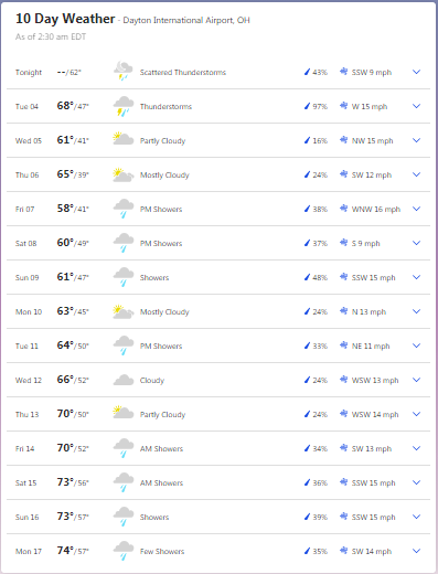
Only hit 84. NWS forecast high today was a little too warm.
-
Based on the graphics, Brett seems to be hinting persistent troughing from the Midwest to the Northeast.
-
Time to punt June soon https://www.accuweather.com/en/weather-blogs/anderson/heat-to-concentrate-over-the-western-u-s-this-month/957748
-
Only hit 69, the 2nd day in a row to not reach 70.
-
Currently in Phase 7 of the MJO. Looks to be going to mainly Phase 8 soon before falling into the Circle of Death.
-
Must be Joe Bastardi in disguise. Anyway, another nail in the coffin occurring today. First the chilly Memorial Day weekend, and now a washout on this 2nd day of June, potentially into the day tomorrow. The weekly overcast days still lingering into this month. If only this was Winter.
-
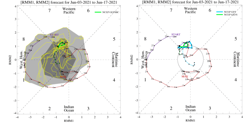
MJO is all over the place into the first half of June.
-
The first several days of June won't really feel like it, though. A crapfest of a start is underway with another fall-like system. To add insult to injury, TWC was hinting temps not getting out of the 60s on Wednesday while the GooFuS is hinting highs barely reaching into the lower 60s. Won't be long until NWS caves to TWC soon.
-
GFS - GooFuS
-
Joe Bastardi, if you're reading this, you got your wish.
-
Meanwhile on Saturday and Sunday, according to today's 12z GFS: Around 50 on Saturday: Around 60 on Sunday: If both Friday and Saturday are going to be overcast, may as well be the case for the entire weekend. Chilly Memorial Day weekends can be a sign of a cold summer ahead.
-
Maxed out at 88 today and yesterday. It's the highest it's going to get for at least the next few weeks.
-
Based on the radar, imagine that kind of setup happening in the Winter instead.
-
6-10 day: 8-14 day:
-
After Washout Week over this past week, only reached 48 degrees on this Mother's Day, several degrees above the record low maximum temp while CVG reached 66 degrees and CMH reached a midnight high of 51 degrees. Certainly the coldest high temperature we'll get for this month. Third overcast and rainy Mother's Day in a row. Want to bank on Mother's Day getting more worse for a 4th year in a row next year? With today's rainfall and not even reaching the middle of May yet, DAY already has 3.25" of rainfall so far this month. Hope it isn't a sign that we go for one of the top 10 wettest Mays on record.
-
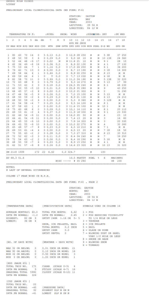
Let's say May is 100% done. Time to root for the May 2003 analog! May 2003 had a record 21 days with measurable rainfall the entire month.