Spartman
-
Posts
1,219 -
Joined
-
Last visited
Content Type
Profiles
Blogs
Forums
American Weather
Media Demo
Store
Gallery
Everything posted by Spartman
-
Winter 2020-21 Medium/Long Range Discussion
Spartman replied to Hoosier's topic in Lakes/Ohio Valley
Right before a minitorch to end January and again on day 10, with a nickel-and-dime system in between to kick off February. Meanwhile, the 00z GFS is a shutout for a majority of IL, IN, and OH. Heading to February, the MJO is supposed to fluctuate between phases 6 and 7 before eventually settling into the latter phase.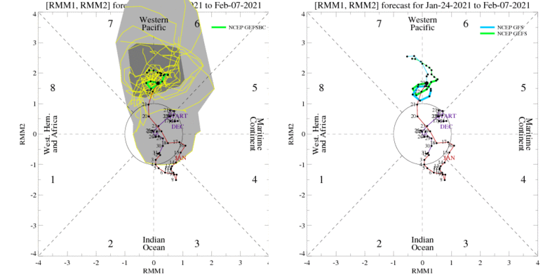
-
Jan 24-26th Potential Something Part 2
Spartman replied to Chicago Storm's topic in Lakes/Ohio Valley
Some of this is given to Indy and Dayton, as well. -
Not as suppressed to the South on the 00z Euro.
-
It's all Covid's fault!
-
00z GFS: (Cue TPiR losing horns) Just wait until Euro caves to that! The 00z GDPS and 00z UK (latter not much, though) both have already. Even Cincinnati is screwed, especially when they're currently tied for the 5th least snowiest January on record. 00z GDPS: 00z UK:
-
Jan 24-26th Potential Something Part 2
Spartman replied to Chicago Storm's topic in Lakes/Ohio Valley
Close to being gone. Very little snow for Ohio on the 00z NAM. -
Jan 24-26th Potential Something Part 2
Spartman replied to Chicago Storm's topic in Lakes/Ohio Valley
Meaning Cincinnati is the pick spot for the snowfall of all the state of Ohio. The northern parts of the state, like Toledo, are unfortunately screwed. -
DAY is just 0.2" away from reaching double digits this season after receiving 0.3", currently totaling 9.8" for this season. CVG now ties for the 5th least snowiest January on record with today's snowfall of 0.2", currently totaling 0.6" for this month. Top 10 Least Snowiest Januaries for Cincinnati: 1. 0.2" - 1919 2. 0.3" - 1993 2 (T). 0.3" - 1934 4. 0.5" - 1973 5. 0.6" - 2021 (as of 1/24) 5 (T). 0.6" - 1931 7. 0.7" - 2020 8. 0.8" - 1983 9. 0.9" - 1924 10. 1.0" - 1969
-
Winter 2020-21 Medium/Long Range Discussion
Spartman replied to Hoosier's topic in Lakes/Ohio Valley
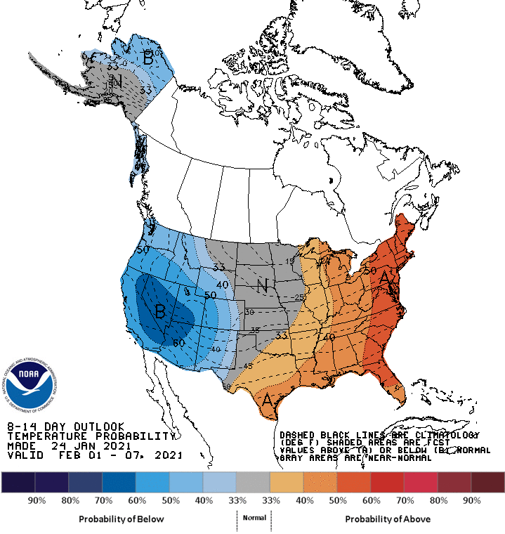
12z Euro: Around end of January on the 12z Euro: 18z GFS: Pretty much a torch beyond Day 10. 6-10 day outlook heading into February: Not as much of a torch on the 8-14 day outlook, though:
-
18z GFS: 18z NAM: 12z GDPS: 12z UK: 12z Euro: Allan seems to favor the Euro, UK, and parallel GFS:
-
Jan 24-26th Potential Something Part 2
Spartman replied to Chicago Storm's topic in Lakes/Ohio Valley
18z NAM: -
06z GFS:
-
Winter 2020-21 Medium/Long Range Discussion
Spartman replied to Hoosier's topic in Lakes/Ohio Valley
00z GFS: 00z Euro (torch periods during the last few days, including Day 10, of the run): 00z GDPS: -
00z GFS: 00z GDPS: 00z UK: 00z Euro:
-
Jan 24-26th Potential Something Part 2
Spartman replied to Chicago Storm's topic in Lakes/Ohio Valley
At least DAY would get some of that snow on this Euro run. 00z HRRR: -
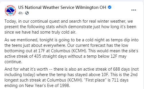
Got down to 13 this morning. Coldest temp since 14 degrees on December 25-26. This will be the coldest low for this season.
-
Wait until it eventually caves to the Euro....
-
Cincinnati with the highest snowfall of all, shades of February 1998. Easy toss, though.
-
12z GDPS: 12z UK: 12z GFS: 12z Euro still doesn't really want to take any part of this:
-
00Z GDPS: 00Z Euro:
-
00z GFS:
-
18z GFS: 12z GDPS:
-
Winter 2020-21 Medium/Long Range Discussion
Spartman replied to Hoosier's topic in Lakes/Ohio Valley
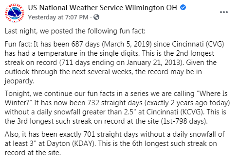
Can't agree more about early February. Here's a post from the Tennessee Valley forum regarding that timeframe. -
From NWS ILN office: One of their posts yesterday:
-
00z NAM: