The 4 Seasons
-
Posts
7,985 -
Joined
-
Last visited
Content Type
Profiles
Blogs
Forums
American Weather
Media Demo
Store
Gallery
Everything posted by The 4 Seasons
-
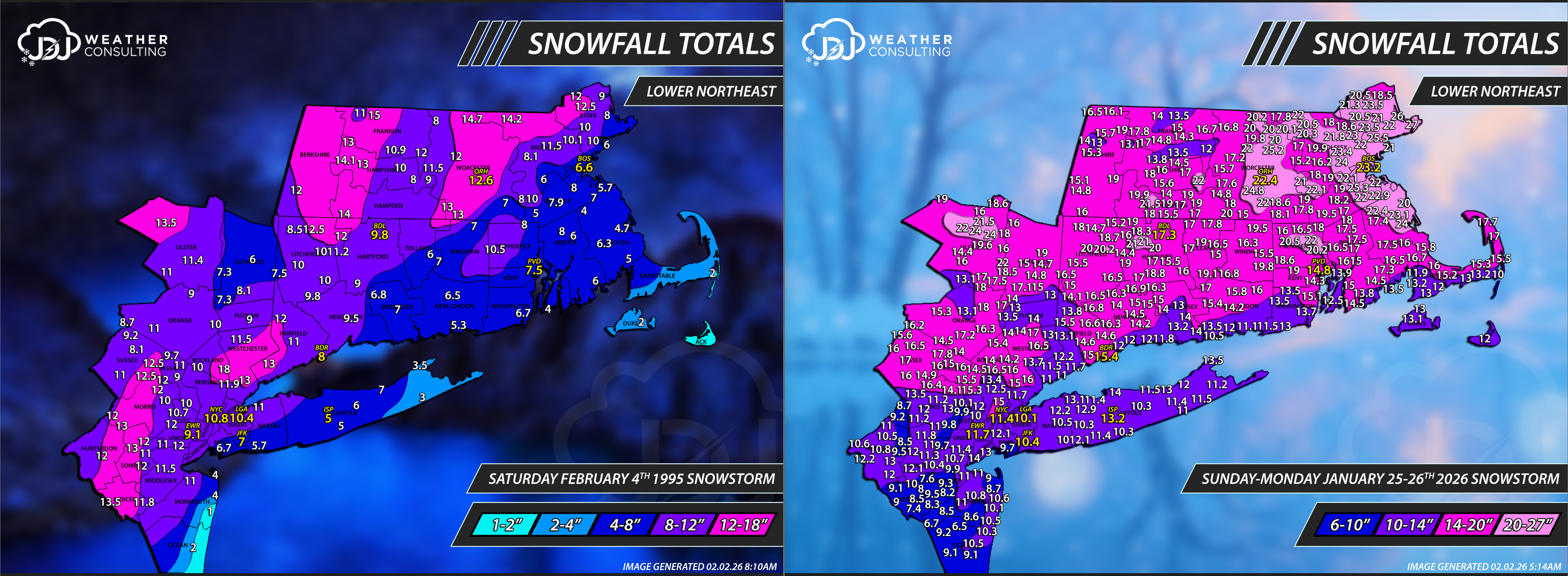
Reports were tough to come by back then, all we had was essentially COOP and climate sites. NWS just had started doing public information statements during the 96-97 winter. BOX did not do them 95-96. I just wanted to showcase the insane difference of reports now vs 30 years ago when we were essentially pre-internet era (i know dial up existed). It makes doing these analysis maps so much more difficult and time consuming but way more accurate and i am grateful for the huge network of spotters and various programs we have in the 2020s.

-
A little too late but thank you
-
Frozen arctic tundra for Barrow
-
Cape and the Islands have done well, though ACK not as much. Theyve gotten skunked a few times when MVY has done well. The difference between Dukes and Nantucket is pretty stark.
-
3rd update on the season-to-date snowfall maps. Thanks to everyone who sent me reports, i tried to use most of them if i could fit em in. I didn't expect to do an update so soon after the last one but we had a significant amount of snow since Jan 20th. Reports are from here, cocorahs, COOP and official climo sites. You can always find these on the site as well as the CT map and Tri-State Area. https://www.jdjweatherconsulting.com/seasonal-snowfall/25-26-seasonal-snowfall Progression:
-
Snowfall-to-date maps updated (#3 for the season). Thanks to everyone who sent reports, i tried to use most of them if i could. Reports are from here, cocorahs, COOP and official climo sites. You can always find these up on the site as well as CT and Southern New England maps. https://www.jdjweatherconsulting.com/seasonal-snowfall/25-26-seasonal-snowfall Progression:
-
 36 and melting rapidly with this mid-august sun angle.
 -
just give it 24hrs and well back to spring again
-
i know it's thick enough but that picture looks terrifying, just anxiety inducing looking at it.
-
-
your cocorahs has 36.2 fyi, so its 38 even?
-
You sent me 22.2 on Jan 20th 22.2 + 4 (Jan 21-22 surprise) + 19 45.2
-
Guess The Date Of The Next 12"+ Snowstorm In The OKX Zones
The 4 Seasons replied to bluewave's topic in New York City Metro
yeah, it was def a north/south gradient. Actually a prettty historic event way north with amounts over 18" in far northern MA. It was the 6-7th btw. https://www.jdjweatherconsulting.com/jan-6-7-2024 -
do you have a season to date snowfall
-
isn't that from the simpsons? Shame if we stop doing them and go to permanent EDT, might not have a winter anymore.
-
it's there now. limited number of reports as there was no cocorahs at the time and NWS wasn't doing snowfall PNS yet...so it's just COOP and climo sites to go off of. But its up with radar/sfc/snowfall maps.
-
If anyone has season-to-date snowfall totals let me know as i'm thinking about doing another update this week for seasonal snowfall maps. -Thanks
-
Depends on where you live but every climate site in SNE/Tri-State is above to well above season-to-date snowfall. That is, of course, going to fall to closer to normal over the next 7 days or so. I might do another season-to-date update this week if anyone wants to give me their snowfall totals in SNE.
-
It's an ensemble mean, otherwise i wouldn't have mentioned it. But yeah still pretty far out there. I'm sure we'll get at least 1 or 2 threats in mid-late feb. AI is still in it's very early development but it's caught my eye to be at least worth watching and taking note of this winter. Especially Euro AI/AI EPS, it's done well from my perspective
-
Possible coastal storm centered on Feb 1 2026.
The 4 Seasons replied to Typhoon Tip's topic in New England
Snowfall totals from this "event". Decided to paint ACK with 1-3" range despite no reports from there based on radar and ACK ASOS obs. -
Possible coastal storm centered on Feb 1 2026.
The 4 Seasons replied to Typhoon Tip's topic in New England
first time i think ive ever seen someone talk about 2-3" drifts and not be a typo. -
AI EPS is pretty weenieish 13-16th
-
He's the Bakersville COOP that ive seen on there for the past 100 years? I'm not surprised now on why it's often so extreme
-
Possible coastal storm centered on Feb 1 2026.
The 4 Seasons replied to Typhoon Tip's topic in New England
Highest reports in Barnstable - 1.2" N Falmouth Dukes - 1.3" West Tisbury Nantucket - No Reports (assuming 1-2 there) What a bust for them watches for 4-8 and the coastal barely scraped ACK and that was about it. Everything in Dukes and Barnstable was from the OES on the western edge, most of Barnstable saw virtually nothing. -
27 and 49 bumping the mean way up with warning snows for that area