
The 4 Seasons
-
Posts
7,985 -
Joined
-
Last visited
Content Type
Profiles
Blogs
Forums
American Weather
Media Demo
Store
Gallery
Everything posted by The 4 Seasons
-

Feb 10-11 Mid Week Minor Event - Ride the hot hand?
The 4 Seasons replied to HoarfrostHubb's topic in New England
and @CoastalWx it's funny because i made a comment when i did the 2nd update in late Jan to the seasonal snowfall that S/SE Essex county was in a massive snow hole and probably had the biggest deficit of snowfall to date in SNE. It's almost as if mother nature saw this and was like welp lemme fill in that hole and even it out, but then went wayyy over board and now they're a snow bubble there, not a hole. Pretty wild. Rockport to Marblehead just got smoked after Jan 20th. -
@MJO812 lmao you got bamboozled and hoodwinked, saw that coming from a mile away. AIs were never on board
-
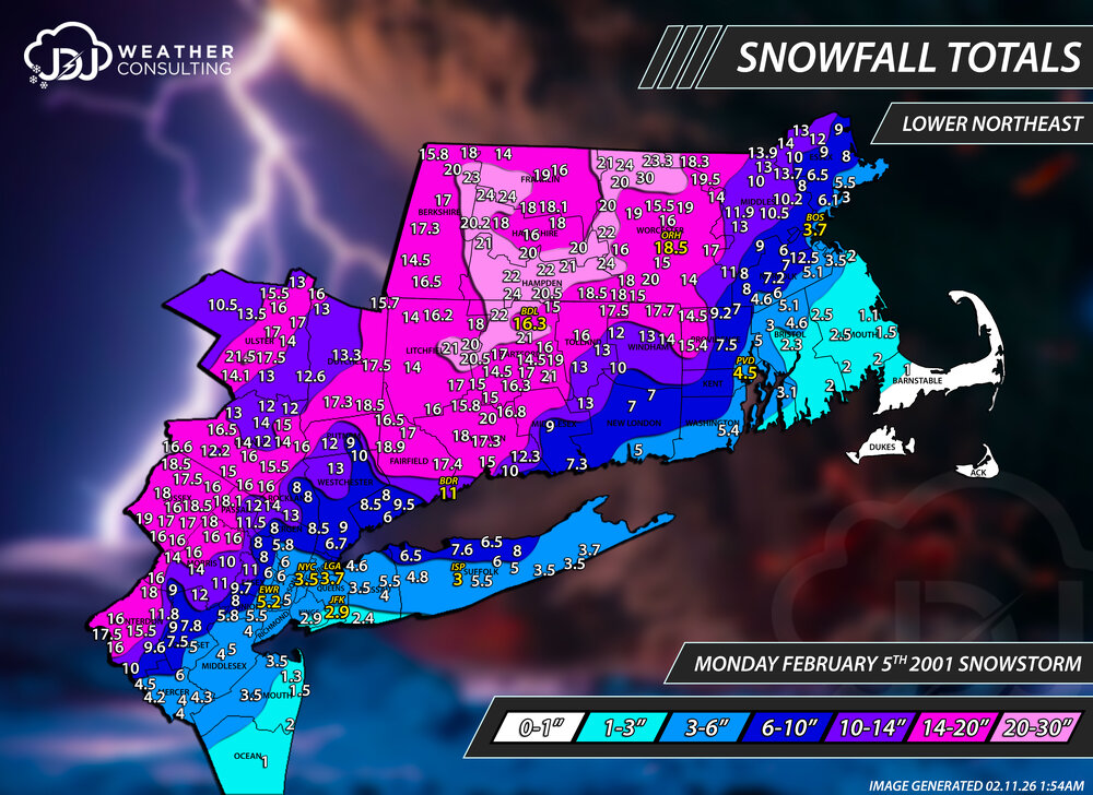
EDIT: Updated map again for additional reports in Ulster and Berkshire counties. We just crossed the 25th anniversary of what is my #1 all-time fav snowstorm. @CoastalWx just linked me to a page about the 25th anniversary of the great Apr 1, 97 blizzard and it got me to thinking about this one. It doesn't get mentioned very often and we've certainly had bigger storms, even recently. However, Feb 2001 is no slouch and a lot of areas received 1-2ft+ in a short amount of time. This storm as well as Dec 2000 and Mar 2001 are what got me interested in meteorology at young age. As Scott as mentioned with Apr 1, the nostalgia and way i felt that day can never be duplicated. Totals alone may not seem like that big of a deal but this stands out and holds my #1 spot for several reasons: Over performer to the max - Forecasts just a couple days before were for rain/snow showers with <1" possible . The day before, in the morning a WS Watch went up for 4-7". And even the morning of the event the forecast was only 5-7". Local news snowfall maps were generally 3-5/5-8/8-12 south to north. 12 hours later 14-25" of heavy wet snow blanketed the state. Road crews were caught off guard and secondary roads remained unplowed for over a day. Flake size & Rates - To this day i haven't seen flakes that large, half-dollar sized aggregates stuck together. I read many reports about people noticing this during the beginning of the storm. Snowfall rates of 2-4" per hour late morning into early afternoon. Thundersnow - First time ever i witnessed thundersnow and at the time i had no idea that was even possible during a winter storm. I just happened to be looking outside right during dusk about 5pm or so and watched as a CG strike hit just a couple hundred feet away with heavy snow/sleet following it. Timing - The timing was perfect starting just after 9AM and lasted through the entire day with over a foot of snow by dark. Schools were closed for 2 days with a delay on the third. I just finished replotting this event for the 25th anniversary and included a new lower northeast map as well. There's a full radar loop up on the site and surface animation but i really can't find much on this storm so if anyone has any free use images or radar please post em here. https://www.jdjweatherconsulting.com/feb-5-2001 On February 5, 2001, the Philadelphia area was hit by an unexpected snowstorm that trapped students in schools across the region. What began as a rainy morning quickly descended into chaos. By midday, the storm in~.mp4
-
Feb 10-11 Mid Week Minor Event - Ride the hot hand?
The 4 Seasons replied to HoarfrostHubb's topic in New England
Thank god. ...and yes they do, a threat worth still watching at least with better trends -
-
It's funny looking at individual members because the whiffs are still a plenty but a lot of the hits are absolute nuke historic level 1-3ft storms across the region all or nothing at least more are showing up now
-
Feb 10-11 Mid Week Minor Event - Ride the hot hand?
The 4 Seasons replied to HoarfrostHubb's topic in New England
Nice event from N CT, N RI through Taunton and north looks like 1-4 based on totals im seeing. If anyone has any reports anywhere in SNE lmk, ill do a map today, thanks! -
based on this i expect wxbell to be like a 2-4 mean, which will still be an improvement
-
I know, we just need to see some half-way consistency between cycles and not this back and forth ping pong. Also like to see AI get more bullish. But yeah, trends were clear at 00Z for the most part. Well see what happens in 12 hours. The runs give us the runs
-
ill see you tomorrow at 12Z when the rug gets pulled again, im not convinced in the slightest this isn't just another head fake at this range. Enjoy it now
-
Go for it, watch how fast it gets locked again.
-
i knew it, told ya
-
we're gonna get whacked
-
Feb 10-11 Mid Week Minor Event - Ride the hot hand?
The 4 Seasons replied to HoarfrostHubb's topic in New England
wonder if TFlizz will get a coating?? jfc just enjoy the snow. another solid accumulating event there and nearing 40" in early Feb. -
right
-
UKMO looks the same
-
00Z models coming back north again, this storm won't die. Why do i have a feeling 00ZEC OP is gonna be another tease for the 4th time now...
-
Feb 10-11 Mid Week Minor Event - Ride the hot hand?
The 4 Seasons replied to HoarfrostHubb's topic in New England
Started this main band as sleet now its pouring freezing rain. moderate at least. 30F -
i bet its an under measure. Who knows what was going on back then in the dinosaur ages when there was literal horse and buggy. Kocin has said he thinks the NYC report is wrong and they got more than whats official. Who knows.
-
Feb 10-11 Mid Week Minor Event - Ride the hot hand?
The 4 Seasons replied to HoarfrostHubb's topic in New England
That's surprising based on some of the obs ive seen on here so far about arctic sand and dense small flakes -
Feb 10-11 Mid Week Minor Event - Ride the hot hand?
The 4 Seasons replied to HoarfrostHubb's topic in New England
? i dont know what you were expecting, you still look fine for 1-2 -
Feb 10-11 Mid Week Minor Event - Ride the hot hand?
The 4 Seasons replied to HoarfrostHubb's topic in New England
flurries about 10 minutes ago, steady light snow now -
Feb 10-11 Mid Week Minor Event - Ride the hot hand?
The 4 Seasons replied to HoarfrostHubb's topic in New England
wow, thats solid so far, i dont see how you dont make it to near 4 or maybe a little more -
Man what I would pay to see a repeat of that verbatim. Just for the melts alone. Ultimate 2015 redemption It was good for SNE. It's still one of my top 10 storms. 10-30" for most, save SE areas. Bad beat for PHI to NYC though https://www.jdjweatherconsulting.com/mar-4-6-2001
-
by Judd Caplovich?


