
The 4 Seasons
-
Posts
7,985 -
Joined
-
Last visited
Content Type
Profiles
Blogs
Forums
American Weather
Media Demo
Store
Gallery
Everything posted by The 4 Seasons
-

Friday February 6 FROPA / WINDEX small event
The 4 Seasons replied to HoarfrostHubb's topic in New England
i bet it is, lucky you, congrats. you got your own little private WSW up there, how much so far? -
Friday February 6 FROPA / WINDEX small event
The 4 Seasons replied to HoarfrostHubb's topic in New England
0.9 and steady light snow. nice refresher -
Friday February 6 FROPA / WINDEX small event
The 4 Seasons replied to HoarfrostHubb's topic in New England
looks that way Washington/Kent counties are also getting smoked right now -
Thats one for the record books, even though i didnt get those 20 burger amounts it was still one of the greatest storms ive ever experienced. 7F and S+ during daylight hours the whole day is unbeatable.
-
Friday February 6 FROPA / WINDEX small event
The 4 Seasons replied to HoarfrostHubb's topic in New England
2-4 definitely verifying in E CT probably some higher numbers gonna come in. Looks like another positive trend/bust again -
Friday February 6 FROPA / WINDEX small event
The 4 Seasons replied to HoarfrostHubb's topic in New England
Nice enjoy, I'm about 1 so far -
Friday February 6 FROPA / WINDEX small event
The 4 Seasons replied to HoarfrostHubb's topic in New England
There is no way 33" is 115/136 to date. It might be 115/136 for the whole season but not to date. Impossible. Everywhere is above climo snowfall but you're in the bottom 16%? No. To date you are near or above normal snowfall, I don't need to see the records to know that. If it ended here sure you'll be 115th. But that's not happening as Cumberland is about to get 3-6" more today with who knows how much the rest of February march and April. -
Friday February 6 FROPA / WINDEX small event
The 4 Seasons replied to HoarfrostHubb's topic in New England
Yeah it's probably the best start to winter in the past 10 years, especially considering the snow pack and temps. -
Friday February 6 FROPA / WINDEX small event
The 4 Seasons replied to HoarfrostHubb's topic in New England
You are living on another planet. Every single climate site is above climo snowfall. Your are completely wrong on nearly every single point. This is through February 3rd. They are all still above and will go up after this storm is done. Your area just got a historic 18" snowstorm with way below normal temps, deep snow pack, a 3-6" storm today and you say it's all time horrific you are delusional. There is no one on this site that would agree with you, I guarantee that. Oh and you just near jackpotted with over 7" on a storm that could have really gone OTS. (BDR) - 33.2"/16.2"/205% (BDL) - 35.8"/28.1"/127% (NYC) - 21.1"/15.5"/136% (EWR) - 25.2"/16.5"/153% (PVD) - 25.6"/20.3"/126% (BOS) - 34.1"/25.8"/132% (ORH) - 49.9"/38.5"/130% -
Friday February 6 FROPA / WINDEX small event
The 4 Seasons replied to HoarfrostHubb's topic in New England
Final CT from early yesterday morning. -
Friday February 6 FROPA / WINDEX small event
The 4 Seasons replied to HoarfrostHubb's topic in New England
Beer? I'm like mind blown that anyone in RI could complain about this system. There has been amazing trends for everywhere in RI. This looked like it could easily have been a general C-2/1-3 across the area but models honed in on a norlun for RI. Even 0.3-0.4 can get you to 4-6" and with this, that's a huge win. And there is no one in SNE that would say this winter sucks balls unless you hate snow. It's been incredible so far, nothing like the last 3. Everyone's above climo. -
Friday February 6 FROPA / WINDEX small event
The 4 Seasons replied to HoarfrostHubb's topic in New England
E CT and RI is getting lit up. S+ at westerly -
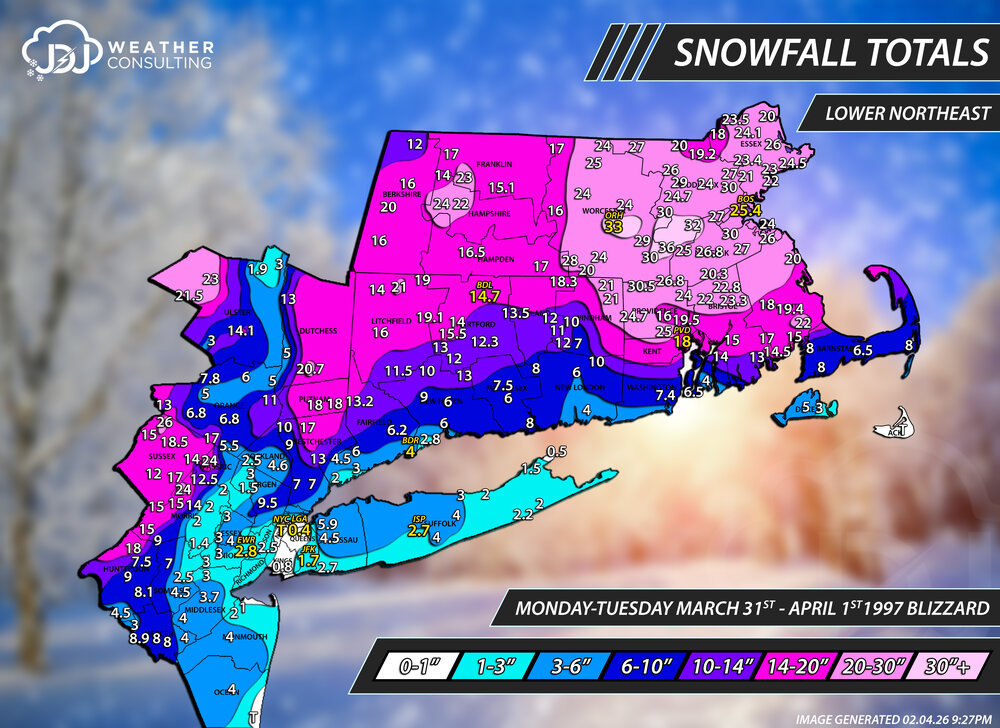
@CoastalWx @Chrisrotary12 I updated all the maps for April Fools '97 as well as added a new Lower Northeast view map with all the climate sites on it. I also added that radar loop from BOX you posted in the other thread for this storm, and i sped it up a bit. Also refreshed all the maps for the March 3-4th, 2019 and December 1-3rd, 2019 storms + added the northeast maps for those as well. I think that Dec 2019 is one of the craziest looking maps i've ever done, quite a gradient and really cool to see that bending of higher snow totals towards the CTRV/91 https://www.jdjweatherconsulting.com/apr-1-1997 https://www.jdjweatherconsulting.com/mar-3-4-2019 https://www.jdjweatherconsulting.com/dec-1-3-2019
-
good cause i kept the 26
-
27? I have 26 from the PNS where do you see 27? Hingham COOP is 23. Is that from someone you know from there
-
I don't know how i missed BDL. I bet it was during the time that 1996-2003 was almost completely missing and they added it back i remember Wiz and I were talking about that. 14.7 BDL
-
Got it. Anything else? You wanna take it look at it, im editing it now so i can change the lines, ill default to you guys since you are much more familiar with this storm, especially in that area. I don't even remember it. I am bringing the 20" line across like you mentioned.
-
for where? Nashua? i only have SNE snowfall maps but most of those events do have northeast maps and NESIS if available.
-
Yeah you're right going back and looking at the COOP data it does say "miss 1" i must have missed that. I've estimated that I've plotted about a quarter million data points so it's easy to make a few mistakes -ha
-
Ok what about the 18 in Hanson and Scituate? Scituate says it's final and Hanson is 1240pm.
-
what area did that cover and is there anything still available that i can use?
-
which Jan 94? I see theres Jan 3-4, Jan 7-8 and jan 17-18 1994 on Rays WS Archive. The main archive stops at 94-95 so i wont be doing 93-94 storms unless its a big one, then theyll go in the Historic Snowstorms section. Just havent got to many of them yet. There is 7 so far pre 1994 season. I misread the thing i quoted i thought he said 95.
-
Is that Salem 3.6SE you on cocorahs? its almost in the exact same spot you described
-
perfect, thanks. yeah the CDPs used to drive me crazy, but now i just accept it and am familiar with most of the CDPs in CT
-
hey guys im working on something can you tell me more exactly where you are in the town (you can base it on surrounding towns) for example Danbury in the center next to the new york boarder, NE Danbury near the brookfield/new fairfield town line, SE Danbury near Redding, etc.. thanks in advance, you can pm me if you want... and anyone else i forgot @RUNNAWAYICEBERG @WinterWolf @EastonSN+ @tavwtby @Kitz Craver @metagraphica @coriolis @WeatherX


