
Chinook
-
Posts
10,673 -
Joined
-
Last visited
Content Type
Profiles
Blogs
Forums
American Weather
Media Demo
Store
Gallery
Everything posted by Chinook
-
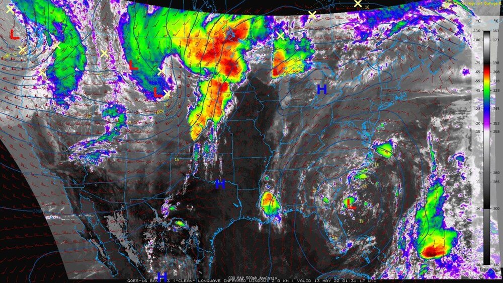
really a huge blowup of convection today last 24 hrs (radar data only)
- 49 replies
-
- 1
-

-
- northern plains
- great plains
- (and 2 more)
-
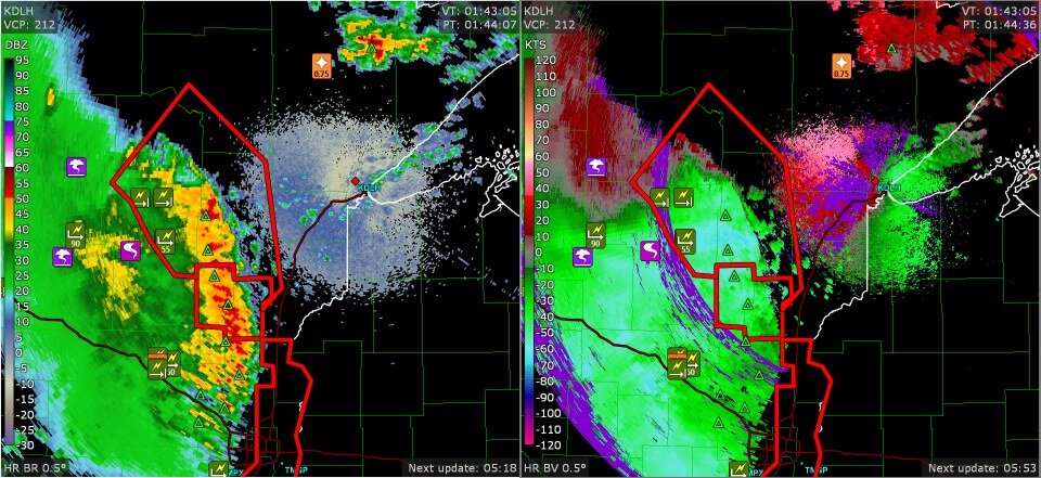
this group of storms has gone from central Nebraska and now is seen on Duluth's radar, continuing with wind reports at some 68 kt winds shown in the clouds on base velocity, where the radar sees the wind the best.
-
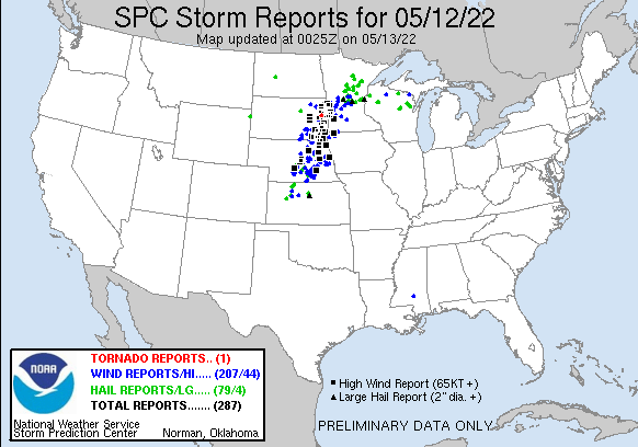
We've got a derecho, most likely, considering the strict official definition of the word derecho. There are a huge amount of storm reports in the same area. Some of these are from the morning in Minnesota.
- 49 replies
-
- 2
-
-
- northern plains
- great plains
- (and 2 more)
-
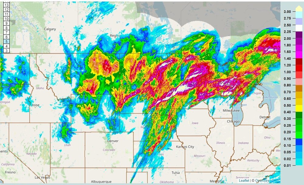
There have been measured wind gusts of 90mph + at Madison South Dakota and Madison Minnesota!
-
Now, KFSD radar showing 80-100 knots base velocity of the rain within the line of storms at the state border. I think a few areas get 80-100mph wind gusts Yes, I know knots are not miles per hour, but hey, this actually kind of makes sense as the measured surface winds are a little below the measured base velocities.
-
New tornado watch in northeast South Dakota, that shows 70% probabilities of 10 or more wind reports, also the same with hail, and moderately high probabilities of tornadoes, EF2-EF3 tornadoes, as it makes sense with the outlook for today.
-
A squall line is already getting going at Broken Bow, Nebraska. Dew points up to 70 at Huron, SD and Sioux Falls, SD. this probably needs a severe storm watch right now
- 49 replies
-
- 1
-
-
- northern plains
- great plains
- (and 2 more)
-
NWS blacksburg confirmed a EF1 tornado south of Wentworth
-
Maybe around 1.0" of much needed rain for me, and about 1.29" since the beginning of the month. Some of these storms have been generous to the Plains. We can say there has been some drought relief for northern Kansas and Nebraska. At least this chart says my area got 100% of average precipitation over two weeks.
-
Funnel cloud at Norfolk south suburbs, VA
-
It does look like tornado debris has been on the radar south of Wentworth, NC.
-
extreme northern North Carolina radar most likely detected a TDS in this vicinity, Walnut Cove to Mayodan/Madison
-
possible hail up to 1" west of Raleigh NC right now. (0.75" reported) I wouldn't be surprised to see a tornado warning west of Raleigh or perhaps east, near Williamston or Greenville NC, given the overall scenario with higher parameters in the area.
-
Enhanced outlook for the tornado (10%) and wind (30%) for parts of Virginia and North Carolina. The tornado 10% area includes areas near Richmond into northern North Carolina. The wind outlook is a larger 30%.
-

Central/Southern Plains Severe Weather Palooza (4/29 - 05/05)
Chinook replied to Powerball's topic in Central/Western States
There was a tornado report with injuries noted at the small town of Brachfield Texas, time was 1924z or possibly a bit later. -
Central/Southern Plains Severe Weather Palooza (4/29 - 05/05)
Chinook replied to Powerball's topic in Central/Western States
west of Shreveport radar- Henderson Texas, confirmed tornado warning -
Central/Southern Plains Severe Weather Palooza (4/29 - 05/05)
Chinook replied to Powerball's topic in Central/Western States
Lockett, TX -
Central/Southern Plains Severe Weather Palooza (4/29 - 05/05)
Chinook replied to Powerball's topic in Central/Western States
only remaining tornado warning now, non confirmed tornado/tornadoes east of Okemah. You would have to use Tulsa radar to see what is going on. -
Central/Southern Plains Severe Weather Palooza (4/29 - 05/05)
Chinook replied to Powerball's topic in Central/Western States
Lockett/Vernon large tornado -
Central/Southern Plains Severe Weather Palooza (4/29 - 05/05)
Chinook replied to Powerball's topic in Central/Western States
This rotation is almost directly over I-40 -
Central/Southern Plains Severe Weather Palooza (4/29 - 05/05)
Chinook replied to Powerball's topic in Central/Western States
Yes, Channel 9 saw the wedge -
Central/Southern Plains Severe Weather Palooza (4/29 - 05/05)
Chinook replied to Powerball's topic in Central/Western States
probably two or more tornadoes have been spotted south of Paducah, TX. This one has been seen recently southeast of Paducah, in mostly rural country -
Central/Southern Plains Severe Weather Palooza (4/29 - 05/05)
Chinook replied to Powerball's topic in Central/Western States
Chasers are showing a large meso above Seminole, quite possibly a large tornado -
Central/Southern Plains Severe Weather Palooza (4/29 - 05/05)
Chinook replied to Powerball's topic in Central/Western States
this is a tornado warning now, southeast of OKC. I guess they had a wall cloud on helicopter view for a while -
Central/Southern Plains Severe Weather Palooza (4/29 - 05/05)
Chinook replied to Powerball's topic in Central/Western States
Seeing some chasers show a tornado, most likely same thing as Reed Timmer is seeing. This is at some of those county borders southwest of Paducah, Texas.


