-
Posts
3,155 -
Joined
-
Last visited
Content Type
Profiles
Blogs
Forums
American Weather
Media Demo
Store
Gallery
Everything posted by high risk
-
FWIW, the AIGFS and ECAIFS runs this morning have some remarkable similarities in the Eastern U.S. for next Sunday, with a high-impact winter storm, even impacting our area. These two AI systems have been bouncing around a lot, so appropriate caution is warranted, but them both agreeing today catches my eye.
-
A round of snow later this afternoon for those east of DC is definitely not off the table. Even runs late Saturday showed a second round later Sunday afternoon - they just disagreed on how far west it would come. And there still isn't a ton of agreement on that......
-
One thing to watch for later today: The NAM and RGEM end the event by mid or late morning for everyone west of the Bay, while the GFS and some HRRR cycles have precip ending by late morning but then bring another round of snow for DC and points east later in the afternoon.
-
Seriously. I'm baffled by he expectation that we should lock in a solution at 240 hours and have every consecutive deterministic cycle not waiver in the slightest.
-
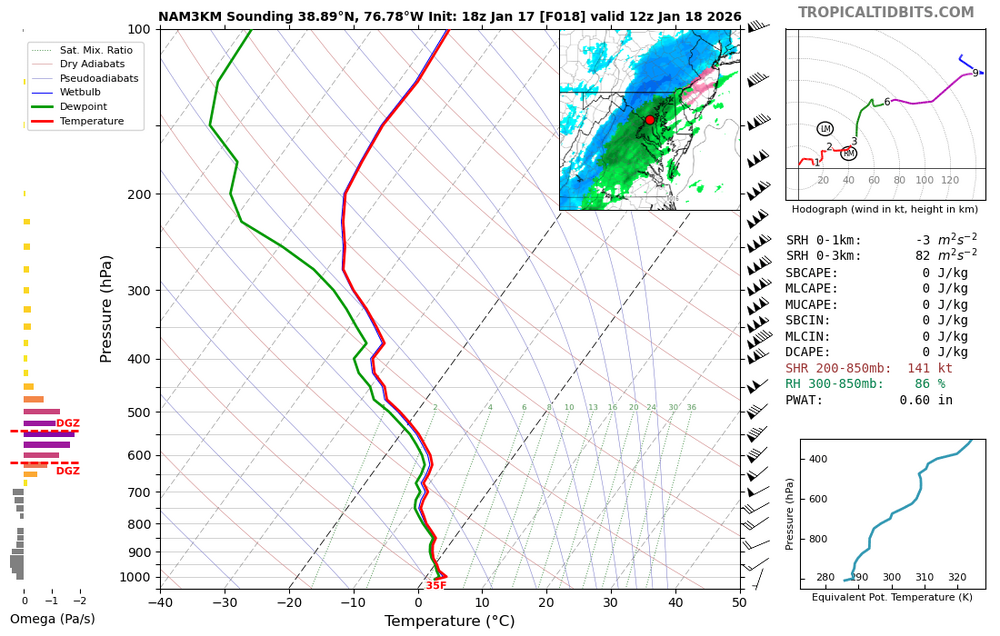
Northern Maryland won't get as warm in the low levels, so verbatim from the 18Z NAM, they're ok for snow. But areas south of I-70 have ugly soundings: That's rain for sure, and it occurs at a time when precip rates are really good. The 18Z HRRR looks the same. We have to hope that this is incorrect, and given the lack of run-to-run consistency, that isn't necessarily just wishful thinking.
-
About 1-1.5" for the Howard County crew with more along the Bay and a decent bit more for the Eastern Shore.
-
The recent AIGFS cycles have more of the longer-range consistency (and overall favorable pattern look) that y'all are craving.
-
I agree. Any pattern that generally prevents "clean" southern stream waves is going to have limited predictability in the medium range.
-
Yes, especially for the Euro ensembles which arrive so much later than the GEFS and GEPS.
-
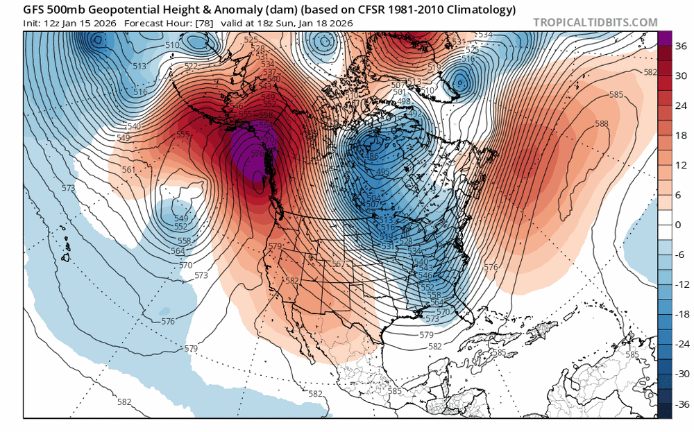
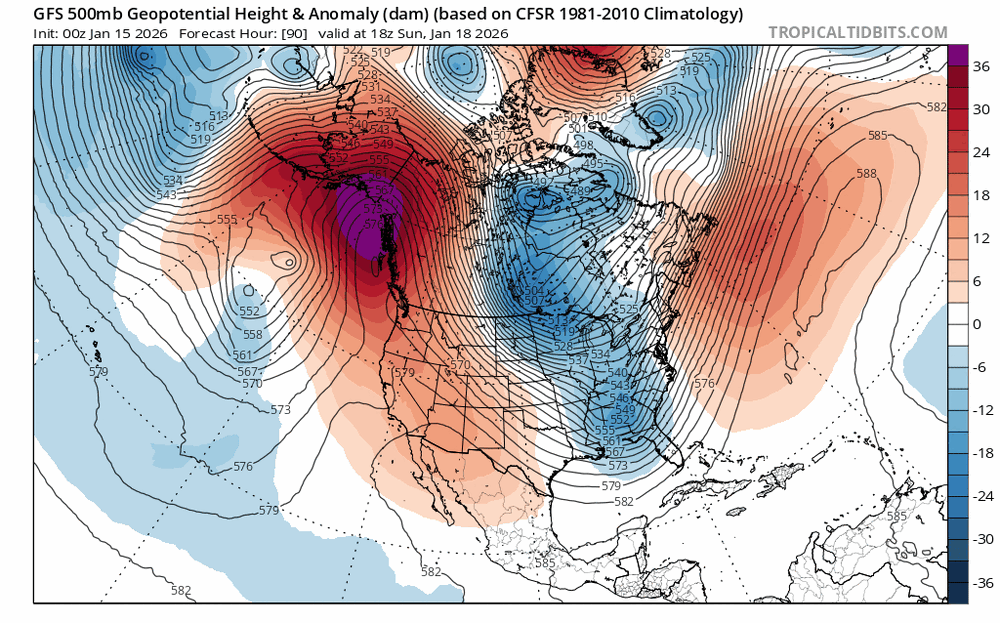
I know that there is a lot of frustration in this thread, and I completely get it, but the "the models suck way more than they used to crowd" (and it's only a few people) really needs to go take a deep breath. Attached are two 500mb GFS forecasts for the same valid time, made 12 hours apart. On the hemispheric scale, they're pretty freaking similar. Unfortunately, there are some minor differences with the handling of the eastern trough, at least partially driven the trailing wave over the upper Midwest. And UGH - those differences are enough to change the track of the east coast low by about 150 miles, and the resulting impact on the band of significant weather is the difference between us having 4" of snow or a partly cloudy day. We all want these perfect fat and wet southern stream systems that we can easily track for days with minimal stress, but the reality is that northern stream systems are dicey as hell. They're small, and they're initialized in data sparse regions. I looked at the two features that will drive the Sunday "event", and the lead wave yesterday broke off of a vortex in central Canada, and I could barely trace the trailing wave back to the polar regions. The small changes in the handling of those features unfortunately cause major changes in the outcome for us. And it should be noted while not every modeling system has shown a good event here Sunday with that trough, they have all bounced around a lot with those two waves and the resulting impact on east coast low formation and associated precip stripe. That speaks to the incredible challenges of complicated northern stream evolution. There is where ensembles help a lot, but we really need to move away from using means (at least inside of Day 5) and focus more on exceedance probabilities, because a handful of snowy solutions among a large number of dry ones can really influence the mean value. Let's hope that we get buried before Valentine's Day so that any further complicated Miller Bs don't cause the chaos in this forum that this one has.
-
The deterministic NBM snow product does indeed weight the meso models more, but that's too far out to include them. Even the SREF wasn't in range. I looked at the forecast in question, and the amount of forecasted snow was only around 1.5", but it was largely driven by some very snowy GEFS members. Of note, the winter products in the NBM update at 01, 07, 13, and 19Z. The 19Z products will include the 12Z GFS but NOT the 12Z ECMWF (which hasn't yet arrived by the time that the NBM winter suite is run).
-
Are these dates off by 1?
-
Temps just above freezing, but it's night, so maybe stickage on a few surfaces? That said, the CAM suite consensus is for just a little bit of snow at the end, with the area of snow expanding after crossing the Bay. One thing to watch for all of us is that any wet spots could freeze early Thursday as temps drop quickly behind the front.
-
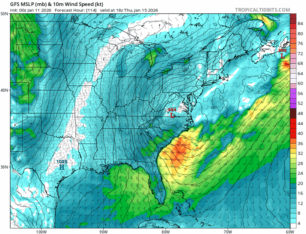
I think that this is very much on the right track. If you look at the 10m wind field, the expected intense circulation on the east side of the storm just isn't there. The 850 wind field looks like garbage too.
-
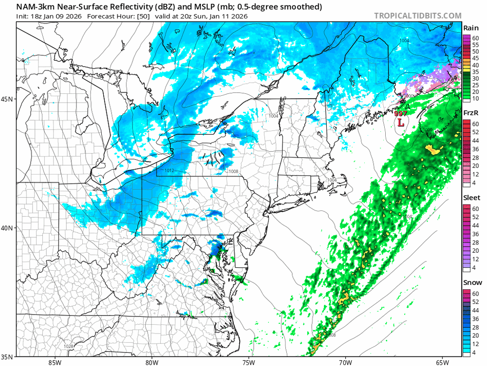
I'm still very interested in tomorrow, but the simulated reflectivities all suggest very scattered activity. Should be fun for those who get under one of those heavy showers, and we'll need that intense omega-driven cooling to combat fairly warm low levels. The simulated reflectivities show rain except for right under the most intense cores.
-
It definitely looked in forecasts from early this week that today would be a taste of spring, but that idea disappeared by midweek.
-
Yeah, the NAM Nest backed off a bit, while the HRRR was All CAMs this evening show the potential, although they disagree on the amount of organization.
-
It has been off the table for us for a couple of days now. The warm front is going to stay south of us, so the 60s and 70s will make it into southern VA and part of the lower Eastern Shore, but we'll be stuck in the 40s, maybe getting to the low 50s Saturday evening with a little mixing. The good news is that the further south position of the warm front puts us in a good position for significant rain.
-
Continuing what it was showing earlier, the NAM Nest still likes Sunday afternoon for some of us getting a burst of convective snow. The CAPE field is non-zero, and other mesoscale models hint at the same idea:
-
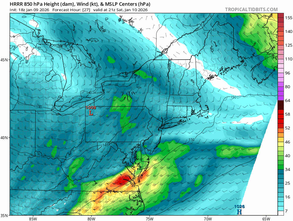
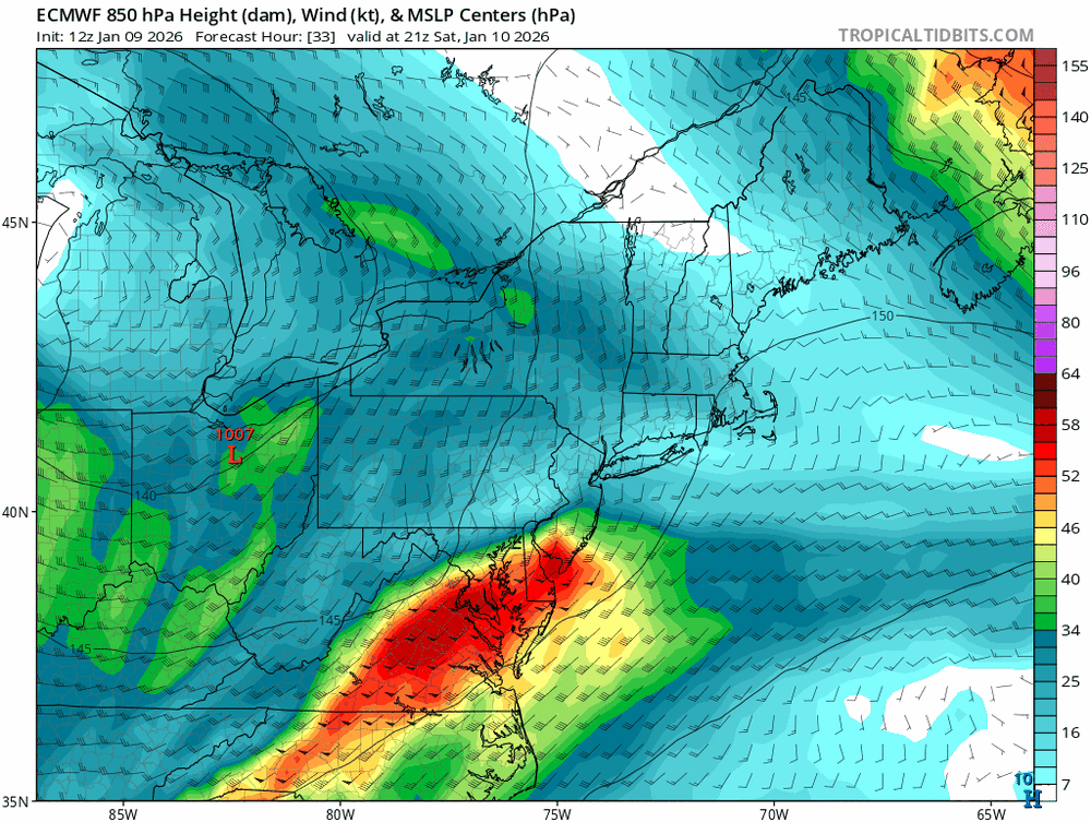
FWIW, the HRRR has a much weaker and more veered 850 mb wind field than most of the other guidance. The images below show a massive difference in the intensity of the overrunning.
-
CAMs suggesting a few scattered heavier snow showers Sunday afternoon.
-
The models seem to all be coming into agreement that the warm front is going to set up to our south on Saturday. The good news: this puts most of our area in a really good location for overrunning, and we should get a fairly decent widespread soaking. The bad news: this will keep the warm sector south the DC/Baltimore metro, and you can kiss a warm Saturday goodbye. Areas well south of DC might still get warm, and *maybe* we all break into the warm air briefly during the evening, but it right now looks like most of us will have a much chillier Saturday daytime than we were expecting.
-
In the interest of "the more you know", I think you need to better understand what ensembles really are. You are correct that the ensemble mean should outperform the deterministic run, but they don't benefit from any extra input data. The premise of the ensembles is that the evolution of a single forecast could be extremely sensitive to initial condition errors (either due to simply not having enough observation data or even directly due to errors in the measurements) and general uncertainly of the atmosphere. By tweaking the initial states across a larger number of run of the same system, we should in theory better sample the amount of uncertainty with the forecast. You get a range of possible outcomes, some sense of whether the deterministic run is on the right track, and a feel for the degree of uncertainty. If the deterministic run is way different than most of the ensemble, it isn't likely to verify. But if a large part of the ensemble agrees with the deterministic run, the evolution of the deterministic run may have some significant merit. (And if the deterministic run is way different than the ensembles, but many ensemble members agree on some very different scenario, that scenario is very much on the table.) Ensemble construction has now gotten more sophisticated with things like accounting for model physics uncertainty. Ensembles can still be very wrong, as the underlying model will have limitations, and we don't always properly sample the uncertainty in the initial state. And it doesn't help that the version of the GFS used by the GEFS is not the one used by the operational GFS. And an ensemble system shouldn't bounce around cycle-to-cycle as some of them do sometimes. Ultimately, we need larger ensemble systems to fully cover the range of possible outcomes, and AI methods may really help in that area. One final comment: be careful looking at low-res, global ensembles at short timescales, as the differences in the initial states for the members need some time to grow. So they have limited utility in the short range.
-
I appreciate that, but I honestly wasn't offended by your post. It has definitely been a rough period lately in the extended range. To me, the fact that we have higher expectations now for Week 2 forecasts speaks highly to the progress that has been made. We just have to remember that certain patterns / transitions still give the models fits, and identifying those in advance is not trivial.
-
I think that recent longer-range forecasting successes, part of the ever-improving state of NWP, have raised our expectations a bit too high. We're not yet at the point where we can expect the Week 2 period to always be forecasted with skill, even for ensemble systems.


