high risk
-
Posts
3,151 -
Joined
-
Last visited
Content Type
Profiles
Blogs
Forums
American Weather
Media Demo
Store
Gallery
Everything posted by high risk
-
Can't emphasize enough that even .01" of ice with a cold antecedent air mass can be an absolute nightmare on the roads, as shown in Ft Worth yesterday. As noted by @chris21the 12z HRRR verbatim is certainly a high impact event - plenty cold, and modest rates (which help accretion), but plenty dangerous on the roads and sidewalks and enough total QPF to threaten some power issues in areas where some of the (patchy) higher amounts fall.
- 891 replies
-
- 12
-

-

-
Definitely worth remembering that when it comes to freezing rain and temps in the 20s, even if model QPF drops from 0.4" to 0.1", it's still a high-impact event.
-
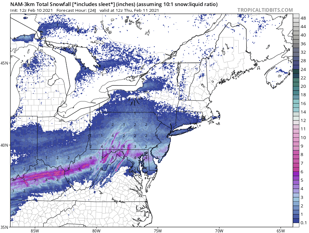
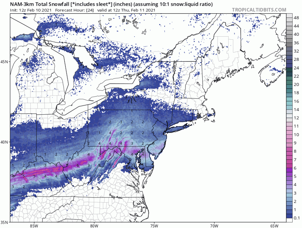
This forecast yesterday from the NAM nest (using 10:1, since snow depth maps failed due to the warmer soil leading in) wasn't too shabby:
-
huge flakes mixed in with the pingers
-
I wouldn't recommend hanging my hat on the GFS para snow maps. Maybe it's right that it will snow in DC (although there seems to be a consensus for sleet turning to rain), but it keeps the surface at 34/35. That's not going to get the job done for accumulations, even at night.
-
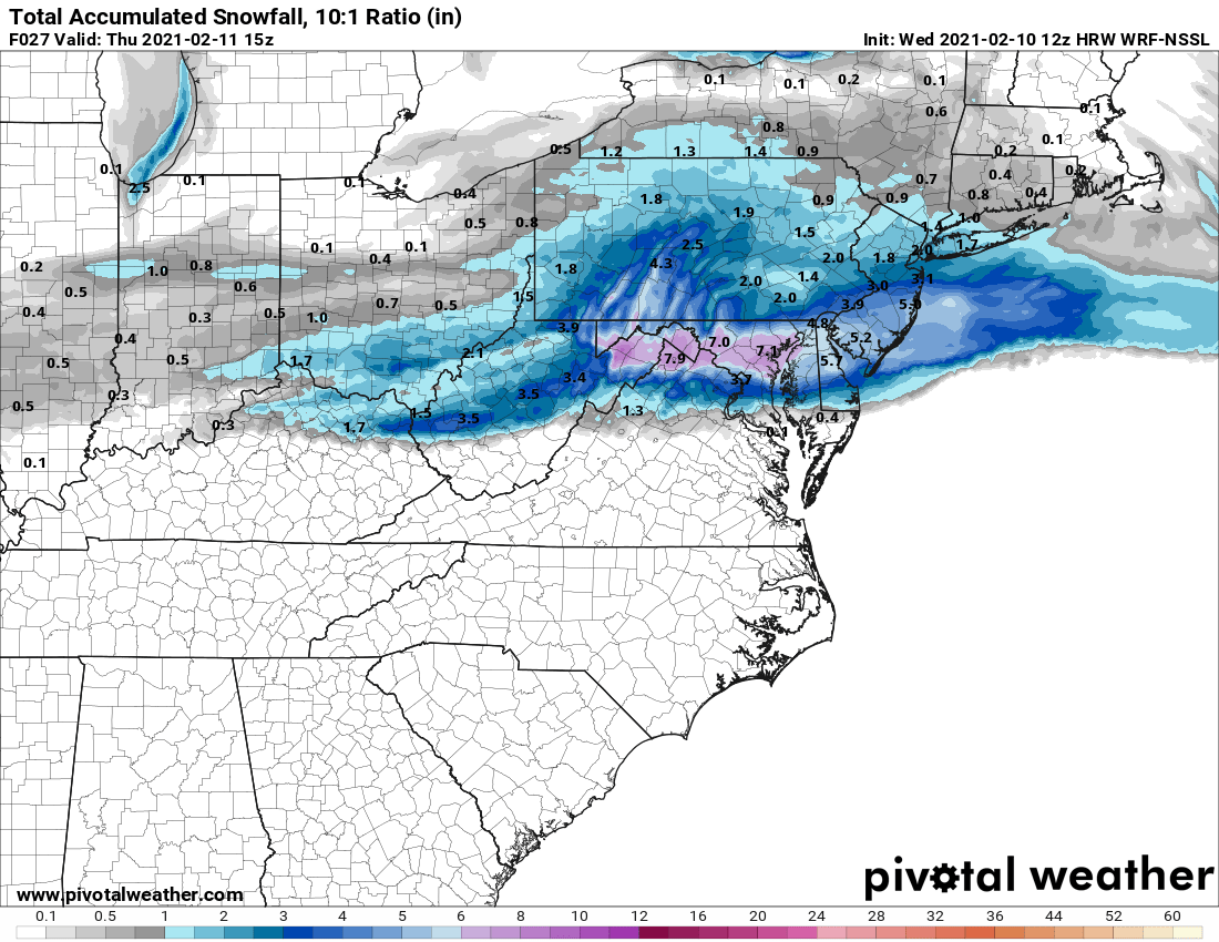
I do like this model, but I suspect it's a bit wet for tonight. I sure do love where it puts the heavier stripe:

-
Hug the 12z NSSL-WRF!
-
The NAM also led the way on insisting that it would be significantly warmer at the surface.
-
Really need to focus on the NAM nest over the parent here. We've seen the parent NAM be too wet in the short range for several events now, and it sure seems that way again. The nest looks far more reasonable. The nest also keeps DC and areas along and south of Route 50 as a mix going to rain, and that makes sense to me again (with the parent slightly further south with the rain-snow line).
-
This is 2 cycles in a row that it has shown this. Being at night will help overcome it a good deal, but it's weird to see the NAM be the warmest model so far for the event.
-
Their details with wave 1 are quite different, but by Friday, the Euro and NAM generally agree on the biggest totals being south of DC (and perhaps well south), with a nasty cutoff for those living further northeast of DC.
-
I sure don't hate this run.... but people in southern MD most certainly will.
-

Feb Long Range Discussion (Day 3 and beyond) - MERGED
high risk replied to WinterWxLuvr's topic in Mid Atlantic
Great point. The difference in snow maps for the NYC area tomorrow between the 12z NAM and GFS is pretty crazy for this short of a lead time. -
Feb Long Range Discussion (Day 3 and beyond) - MERGED
high risk replied to WinterWxLuvr's topic in Mid Atlantic
Definitely, but capturing the position of a boundary and critical details of the related cold air damming is still contingent on having the background synoptic details correct. Once we're confident that is has the big picture correct, definitely rely on its low level temperature details. But we're thankfully not yet at the point where we can have confidence in its synoptic details. -
Feb Long Range Discussion (Day 3 and beyond) - MERGED
high risk replied to WinterWxLuvr's topic in Mid Atlantic
I'm really stunned to see the NAM so warm for Wednesday night / Thursday. Hoping it's just its usual day 3 synoptic struggles, but it certainly doesn't make me feel good. -
Feb Long Range Discussion (Day 3 and beyond) - MERGED
high risk replied to WinterWxLuvr's topic in Mid Atlantic
Colder. Verbatim was snow for those north of DC for a while, then rain or dry, and then a modest thump of snow again for all. -
I came in over 1" a bit south of you, but as pretty as this was, it's been frustrating to watch several bands fall apart on our doorstep.
-
Feb Long Range Discussion (Day 3 and beyond) - MERGED
high risk replied to WinterWxLuvr's topic in Mid Atlantic
Agreed, Bob. This one has high-impact potential for a lot of people here, although the 12z Canadian now has a very different solution, so I don't think that the synoptic details are totally locked in yet. -
Feb Long Range Discussion (Day 3 and beyond) - MERGED
high risk replied to WinterWxLuvr's topic in Mid Atlantic
I'm talking about the Thursday-Friday event. Still time to change, but it certainly looks like we will be too warm upstairs for all snow. My point is that the GFS often wipes out the cold air at the surface and turns us to rain, so when I see it maintain the below freezing temps throughout the event and give us a big ice accumulation, the threat is really legit. -
Feb Long Range Discussion (Day 3 and beyond) - MERGED
high risk replied to WinterWxLuvr's topic in Mid Atlantic
When the model that struggles the most with maintaining cold air damming has a solid signal for a long-duration cold air damming event, I definitely take notice. -
It's weird - I thought it might be an initialization issue, but the HiResW ARW2 (NSSL-WRF) is also initialized from the NAM, and it has one third of the NAM nest precip for my yard.
-
Going through the 00z CAMs, the two NMMB runs (NAM nest and HiResW NMMB) are the only two "wet" runs. The HRRR and HiResW ARW and ARW2 are so much drier.
-
Euro stops the bleeding. It's not as good as the NAM (especially for the northwest folks), but it's notably better along I-95 than the GFS or CMC.
-
With its lower resolution, the NAM parent just generates a nice uniform swath of snow through the area, but the higher resolution nest clearly indicates some impressive bands, justifying the idea that there will be winners and losers.
-
That's an ugly map, but the QPF has 0.5" running right through DC, so I think it's just a little too warm in the low levels for more snow?