jbenedet
-
Posts
7,815 -
Joined
-
Last visited
Content Type
Profiles
Blogs
Forums
American Weather
Media Demo
Store
Gallery
Everything posted by jbenedet
-

Blowvember - and not named for wind potential
jbenedet replied to Go Kart Mozart's topic in New England
I see a string of surface lows in southeastern Canada.... This is a crap setup guys...
-
Blowvember - and not named for wind potential
jbenedet replied to Go Kart Mozart's topic in New England
EPS ftw... AN streak continues... -
Blowvember - and not named for wind potential
jbenedet replied to Go Kart Mozart's topic in New England
This window is quickly turning to "normal" for most. From Boston to Portland, I'd bank on it...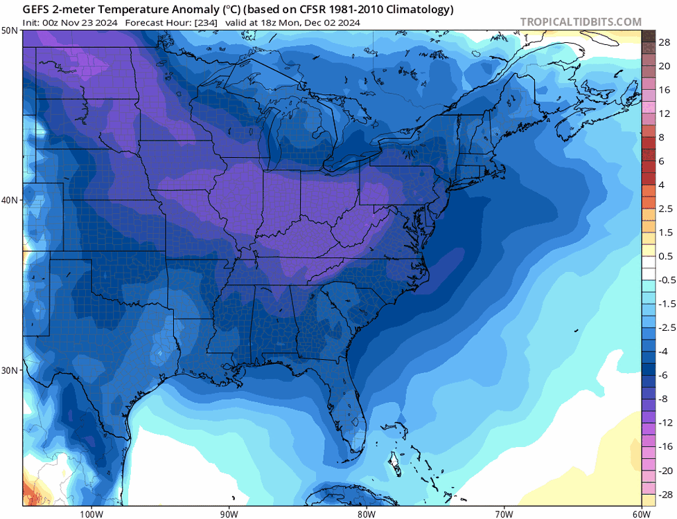
-
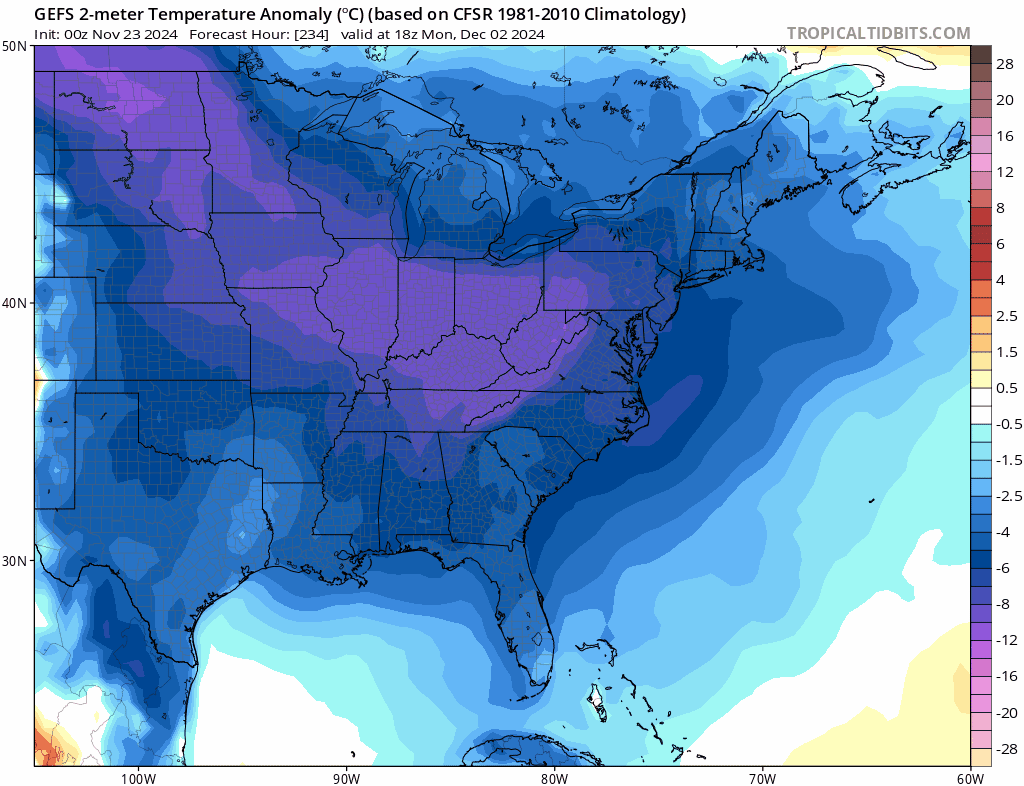
I get what @bluewaveis saying to a large degree, at least what it means for the northeast US. The bulk of the cold is dumping into the southeast US from the mountain west…The northeast will be seeing winds out of the west/wsw, and thousands of miles of mid latitude travel for the arctic airmass to moderate…Yes the overall atmosphere will be BN (cold) but this is not a situation that maximizes the surface cold potential in the densely populated areas of the northeast; quite the opposite when soil temps and SST’s are warm and snowpack to the west and north will be well below normal. For example, I believe DC has a much colder stretch relative to norms than Boston, incoming... Boston and Portland ME could end up pretty close to normal during this stretch.
-
Admittedly from just an observational standpoint here but a lot of what I’m seeing looks like previous years, with best wintry patterns in place in late fall… Relative to last early December, there was even a similar significant cold shot—as advertised for day 10ish—that originated in the mountain west and covered most of the CONUS for ~5 days. I’m also noticing significant -NAO’s/-AO’s with regularity; our problem —snowfall wise— is this has flipped in late December to February time frame to predominately +NAO/+AO. The lack of snowpack in New England and eastern Canada also tracking similarly…. We’ll see if past is prologue…
-
Blowvember - and not named for wind potential
jbenedet replied to Go Kart Mozart's topic in New England
Last night was odd in how the temperature kept rising on gusty northeast winds, up to 49 at PSM around 7z this morning. -
Blowvember - and not named for wind potential
jbenedet replied to Go Kart Mozart's topic in New England
For eastern areas, the much bigger event is Friday night/Saturday morning, but probably going to be a precip “hole” in Central NE. Some, near the Connecticut river will be on the margin of both systems, and won’t get much precip at all… -
Blowvember - and not named for wind potential
jbenedet replied to Go Kart Mozart's topic in New England
Eating the cats, eating the dogs here. -
Blowvember - and not named for wind potential
jbenedet replied to Go Kart Mozart's topic in New England
Saturday 970's in the gulf of maine, with CCB overhead but temps advecting from Ontario, which is in the mid to upper 30's. -
Blowvember - and not named for wind potential
jbenedet replied to Go Kart Mozart's topic in New England
This storm was the great opportunity missed because of late Nov climate and antecedent warmth. This was the storm. This isn’t your table setter or pattern changer; it’s the one to cash in on. And we missed it. -
I agree. Studies focused in/around the UK and Ireland makes a lot more sense at this stage, vs Florida...
-
@bluewave You really don't see the regional off-shoots (Western/Eastern Maine coastal current) of the labrador current in the current SST profile. It seems like there's the Nova Scotia current, but relatively warm, and mostly confined to Cape Breton Island area....Not seeing it extend much into the GOM at all...
-
I've been tracking this mostly in our backyard for how the Labrador current is responding. Does anyone have good historical data for SST's around NS, Cape Breton island and Downeast Maine? I'm still seeing SST's 49-50F in this area, which seems exceedingly warm... What's most odd to me is you don't see any clear temperature footprint of the labrador current as SST's much further south off the coast of NH and MA are in the low 50's...Usually you see a steep drop off in SST's around mid coast ME...
-
Blowvember - and not named for wind potential
jbenedet replied to Go Kart Mozart's topic in New England
We are tracking to have least amount of pack on the ground by December 1st in our overall region; combining Ontario, NB and the northeast US. I know it’s mostly due to dry conditions, in the colder locations in Northern Maine and Canada…but it’s something important to note as we head into met winter. -
Blowvember - and not named for wind potential
jbenedet replied to Go Kart Mozart's topic in New England
I guess the point here is, you really narrow the potential for BN if with -AO and - - NAO --as is now-- and we still generally ++ AN. What's the recipe to land the seacoast of NH into BN territory with some consistency? It's a rhetorical question... -
Blowvember - and not named for wind potential
jbenedet replied to Go Kart Mozart's topic in New England
That axis centered around West Virginia is the goods. We get the stale stacked low remnants. -
Blowvember - and not named for wind potential
jbenedet replied to Go Kart Mozart's topic in New England
6Z EPS says I register AN all week. And i buy it... -
Blowvember - and not named for wind potential
jbenedet replied to Go Kart Mozart's topic in New England
The best mid level height falls are already progged over the mid Atlantic. The -NAO will be significant enough to send the whole anomaly south of NNE. So it wouldn't surprise me to see the interesting wintry weather more over elevations of PA, West Virginia and NJ, while near normal mid level heights are over northern NNE. -
Blowvember - and not named for wind potential
jbenedet replied to Go Kart Mozart's topic in New England
Man what a perfect day for a local hike. No leaves on the trees makes for more sunny areas and the bugs are all gone thanks to a few freezes. -
The landmass there is least wide, and also flat wetlands. SST's are also quite warm. This combination won't allow for much --if any--- weakening before affecting the densely populated areas of Miami dade county. It's one run, but I'd caution against this as an optimistic scenario, especially if it comes in stronger at that angle.
-
Blowvember - and not named for wind potential
jbenedet replied to Go Kart Mozart's topic in New England
Not for nothing the MJO just had a solid pass through phase 8, if we're not scoring some near normal temps, given that backdrop....we are absolutely cooked. -
Blowvember - and not named for wind potential
jbenedet replied to Go Kart Mozart's topic in New England
Upcoming pattern looks AN and dry. Not bigly AN, as seen in recent weeks but +5ish... The pacific is skunked and the -NAO that develops looks to be significant to the point that the pressure tendency in the northeast US is the Canadian surface highs hooking up with the western Atlantic ridge. UL confluence but cold airmasses no where near our region.
-
Blowvember - and not named for wind potential
jbenedet replied to Go Kart Mozart's topic in New England
Normal temperatures “behind the cold front”. -
Blowvember - and not named for wind potential
jbenedet replied to Go Kart Mozart's topic in New England
6z GFS MOS with high of 61 at PSM. It’s currently 52. 65 is in view. -
Blowvember - and not named for wind potential
jbenedet replied to Go Kart Mozart's topic in New England
Roses still in bloom around Dover. Lawns still green. I def enjoy the warmth as long as we stay out of the brown of stick season.