

jbenedet
-
Posts
7,807 -
Joined
-
Last visited
Content Type
Profiles
Blogs
Forums
American Weather
Media Demo
Store
Gallery
Everything posted by jbenedet
-
Imo if the center makes its way ~due east of Tampa, in close proximity you will see the gulf rush into Tampa bay in the direction of Tampa. That would maximize the threat to Tampa specifically
-
The 12z NAM is basically a worst case track for Tampa bay. The more east trajectory after moving into the bay really allows the surge threat to get amplified with the Gulf water rushing in behind the circulation. It’s the NAM but should give some clues directionally on the rest of the 12z suite.
-
IR coupled with radar shows EWRC occurring and the much anticipated expansion of the eye and wind field is well underway.
-
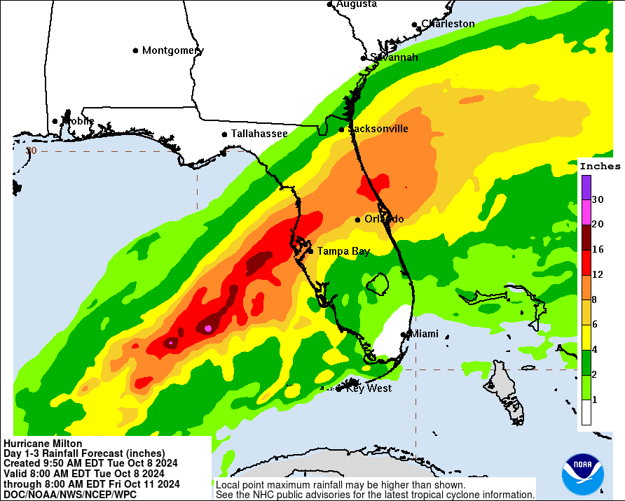
Rainfall threat is not getting enough attention —can already see the PRE well established and intensifying. Incredibly heavy rainfall all day today Tampa on North/East towards Jacksonville
-
Thank you for sharing — but why is there no data around the Yucatán or the west coast of Florida?
-
There’s some caveats to hoping for ticks south if you’re in the south/east section of the current forecast track. The heaviest rainfall is displaced to the north/west side of the CoC. This amount of rainfall carries significant fresh water flooding risks—bunch of small lakes and ponds in the north Tampa area, away from the coast.
-
With respect to the euro op only, and intensity at landfall - today's 6z Euro run was the strongest at landfall @966. A big shift towards the GFS which has been consistently in the 950's... There's pretty damn good alignment now on landfall intensity with the hurricane models. Consensus around 955 mb.
-
There is a second recurve progged in the major guidance, right after landfall. It appears Milton will lose the northerly component to trajectory, and instead head easterly once over land. This is especially evident when looking at the individual ensemble members. A northeast tracking upon landfall then to more E, or slightly N of due east, toward Orlando. Tampa -> Orlando ->Cape Canaveral
-
There is ~100 miles of Florida coastline in the 12’ surge forecast. Being on the northern/western eyewall shouldn’t be cause for relief. The bulk of the surge is collocated with the min SLP, and is not wind driven. This isn’t unique to Milton. The wind direction matters much more for storm surge impacts when you are 50-100+ miles from the center.
-
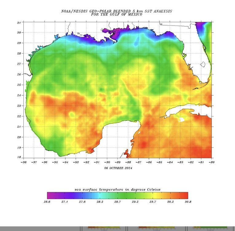
Very warm water in the last 12 hours of Milton’s forecast track before landfall Edit: this actually looks like the warmest water along any part of the US currently.
-
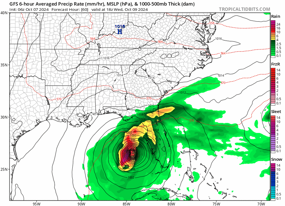
GFS again not showing weakening prior to landfall.
-
The radial expansion of the wind field upon landfall requires a physical reduction in wind velocity; that’s conservation of angular momentum. Some of this exposes the flaws in our hurricane categorization on wind speed alone, but I digress…
-
Yes the wind field will expand significantly. That aside the steep weakening seen on the Hurricane model guidance also has the track furthest north into the worst shear environment. I’m with the globals on track EPS/GEFS, which are further south. Unfavorable upper air, but relatively less hostile…
-
Outside of occasional wobbles, it does appear Milton has lost the southerly component to its trajectory. I think the odds of a clear miss of the Yucatán have gone up a lot since 12z today.
-
Completely different than the GFS. Interesting…
-
There’s def a double-edged sword element to the exact track. I see evidence of a PRE collocated with the north/west quadrant of Milton. The southeast section looks relatively dry. The southeast section will carry the highest winds/surge/coastal flooding but the northwest section will have all the fresh water flooding risk.
-
I don’t see the weakening immediately prior to landfall on the latest global guidance. That was clear consensus up to this point, but seems to be lost at the moment. Here’s today’s 6z GFS for example
-
I wouldn’t bet; but looks very close. The thing with strong majors is they bend the environment; not the other way around.
-
It’s just night and day. The globals were showing a TS yesterday at this time frame, and we have a major. That’s my main point.
-
Clearly with still a non-negligible southerly component to track. We have had the early part of the trajectory shift more south than consensus; it has acted to offset a big change in the landfall location despite the more aggressive recurves being modeled upon closest approach to Florida’s west coast.
-
Hurricane models crush the globals again on short to medium term intensity guidance.
-
Yea and in turn much stronger impacts with wind and surge on the southeast side, much less on the northwest side.
-
For Helene, the hurricane model verification performance for intensity was generally much better vs the globals; especially early on, whereas the globals performed much better on track.
-
It makes sense with the forecast jump given the organization today to achieve a well define LLC. That was the key hurtle, because once the structure is established it has tons of time by Gulf TC standards. I’d love to see the statistical distribution of TC intensity in the gulf vs time (once LLC established) over open water. At over 84 hrs there’s got to be a lot of company in the major+ category.
-
Just a hair below major at 110 mph. I guess they don’t have the confidence for “major” headlines yet. That’s fair and reasonable at this stage.


