jbenedet
-
Posts
7,807 -
Joined
-
Last visited
Content Type
Profiles
Blogs
Forums
American Weather
Media Demo
Store
Gallery
Everything posted by jbenedet
-
Hit 80 at PSM
-
PSM hit 60 yesterday despite being socked in all day in a classic damp and nasty coastal New England day. That’s +5 … Pretty telling on the amount of warming going on locally in the seacoast region…
-
Don’t you manage a landscape/snow removal business? I mean, I get it ….if that’s the case.
-
6z GFS MOS has a high of 49 at PSM…. Man does that have bust written on it….
-
The dews are what tipped me off to the deep arctic origins of this. Those are legit. Airmass from the northwest passage.
-
Arctic airmass and we only -4 for two days; today and tomorrow. Then we +15 and +20… Rinse repeat.
-
Bottomed out at 38. Felt like an idiot this morning after rushing in the plants last night. All would have been fine. I even took the motorcycle into work today….
-
38 for a low. Still didn’t take the plants in. I’ll have to take em in tonight though as we radiate. Only time those progged cold lows verify on MOS is under legit radiational cooling conditions.
-
PSM with 72 for a high yesterday. And that was with overcast moving in by noon.
-
Today is another 70’s in the warmer locations in eastern SNE to seacoast NH.
-
Reality, as in “near normal” will be like a day around here. Sunday, into Monday morning. Monday one of those 30F+swing days. Cold low. Around 30. But By Monday afternoon temps are going to be pushing AN again; 60ish. The deepening -PNA trough is what’s making the transient cold shot possible. But it’s also the big boot with the upper level jet out of the pacific southwest with reach to our region by early Monday.
-
We understand averages I hope. The global average temperature increase is subtle precisely for this reason… Our region is warming much faster than average.
-
When we BN it’s -3; when we AN it’s +15 Not a surprise when you consider our cold source regions are warming the fastest….
-
#uncertainty
-
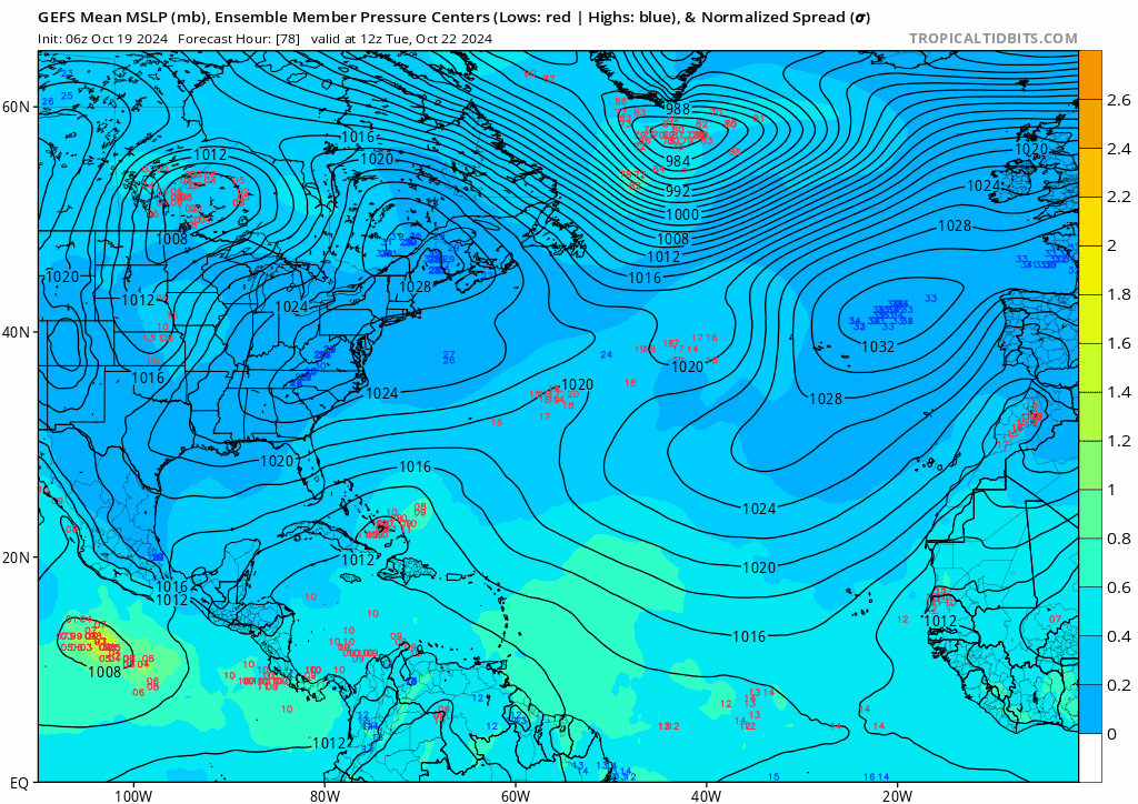
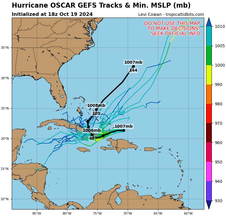
18z GEFS now has ~50% tracks into the Caribbean. Big change from earlier runs. That’s actually the better bet to me vs the sharp recurve northeast after landfall in eastern Cuba.

-
Yea and this lat/longitude with no imminent recurve is a high probability for a US strike somewhere…. The current global guidance says otherwise but it’s not resolved properly at initialization; developing a Mid latitude cyclone; not a TC. So everything off in that regard based on disturbance’s current characteristics. The NHC rightly has this tracking west with the easterlies toward eastern Cuba.
-
I’m about done with this mountain peak snowpack topic but looking at the EPS and GEFS it looks brown up there through early November. Really warm stretch.
-
Above freezing is one thing. But to lose a pack, for days is much higher threshold up there this time of year, but as PF mentioned; not uncommon.
-
I believe it, but it’s kind of surprising given how terribly cold it can be at that latitude above 4000 ft in the middle of summer.
-
The atmosphere is overall pretty cooked by early Saturday. There should be many spots in SE NH and SNE in mid 70’s; locally near 80, both days. What a beaut.
-
The snow at the mountain tops; even mount washington will be gone in the coming days.
-
The pattern upcoming looks really warm. Really effin nice mid Fall weather starting Friday, and improving over the weekend. I’m expecting mid 70’s. As early as this Thurs looks really good with highs around 60.
-
The GFS op is trash for 2m temps. Pretty sure the progged highs will be surpassed by 10 a.m. Today’s 6z MOS should be good with 55 for PSM, but basically a nowcast from that run. Yesterday’s 12z GFS MOS for today’s high was 51! +4 in 18 hours. And that error is with boring Synoptics overhead… Woof.
-
Shocking how cold it gets in the interior on south vs the seacoast. I’m not a fan of early season cold; you guys can keep it. DAW and PSM 39. Even if you give DAW “a few degrees too warm” factor still much warmer than most of you guys points much further south. Only dew around these pahts. All the plants are staying out through late November.
-
Seeing 30% of Florida customers without power is pretty damn telling of the scope and magnitude of the damage considering # palms vs large deciduous trees and ~50% power lines underground.