jbenedet
-
Posts
7,644 -
Joined
-
Last visited
Content Type
Profiles
Blogs
Forums
American Weather
Media Demo
Store
Gallery
Everything posted by jbenedet
-

2025 Lawns & Gardens Thread. Making Lawns Great Again
jbenedet replied to Damage In Tolland's topic in New England
So turns out I have a black walnut tree on the southern edge of my property. Perfectly placed to filter out the worst of the afternoon summer sun. It’s a beautiful tree, generally. Problem is, in the fall for approx 1 month it produces the food for just about every chipmunk and squirrel within a one mile radius. I have decided to put up with it and let nature take its course, outside of me discarding the old walnuts which land on my property, and spray foaming the areas these critters make for homes, I’m letting them be. Saw a large red tail hawk hanging out three houses down on the powerline during this morning’s dog walk, gazing at my tree…. So the medium to long term game is winning… I’m all for this route even with the short term sacrifices, and very pleased that the ecosystem is healthy enough around me to make it a possible homeowner strategy. -
Spooky Season (October Disco Thread)
jbenedet replied to Prismshine Productions's topic in New England
Running out of time for big changes but for a big impact out of Melissa in our region need to see the shortwave out of western Canada hookup with the low over the southeast around this hour. A trend to see the former speed up and the latter slow down, must persist from here on out. It’s not unusual in significant-NAO regimes for this to occur but the current model consensus gives it very low odds. We watch.
-
Spooky Season (October Disco Thread)
jbenedet replied to Prismshine Productions's topic in New England
BN patterns like this which yield near normal temps just brings home how much more needs to go right for accumulating snow chances. Also that these persistent Fall -NAO regimes help to torch our cold source regions in eastern Canada as we move into winter…Hudson Bay, Bay of Fundy, Gulf of St Lawrence…. -
Major Hurricane Melissa - 892mb - 185mph Jamaica landfall
jbenedet replied to GaWx's topic in Tropical Headquarters
Another track with Bermuda in the crosshairs. Still a ways out but losing track of how many times Bermuda has been under significant threat of direct hits from canes past 3 tropical seasons. -
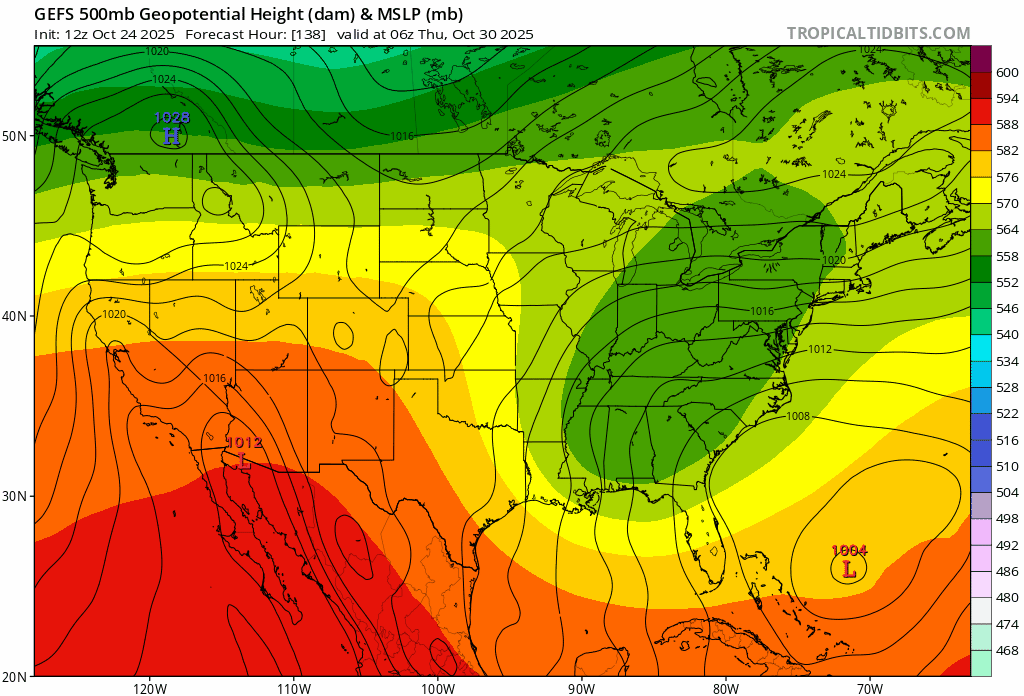
Thought this was pretty interesting. Would be much less so if not for the GFS being biased well east already… To be sure, not looking at Sandy and its forecast as a verbatim but an analog. That’s all. Right now the H5 output consensus is for east of Sandy, but I’m not discounting a hook back to eastern New England… Of course will have to monitor closely especially given the reduction in real time data, as noted above.
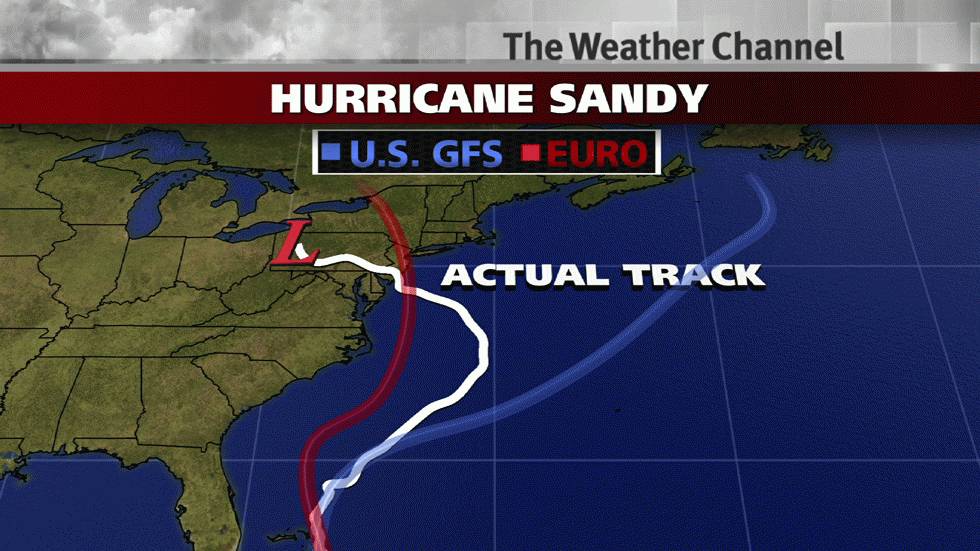
-
Spooky Season (October Disco Thread)
jbenedet replied to Prismshine Productions's topic in New England
Min 39 -
Spooky Season (October Disco Thread)
jbenedet replied to Prismshine Productions's topic in New England
Nothing is “quick” / fast flow as in the teleconnections at the end of the month. This seems like a hiccup in the recent op runs advertising this. There’s a deeply -AO incoming coupled with +PNA and further -NAO conditions. I’m expecting much more northern stream interaction; arctic involvement. When we start seeing snow showing up in guidance for next week in PA and western upstate NY, we’re getting close to the actual outcome… -
Major Hurricane Melissa - 892mb - 185mph Jamaica landfall
jbenedet replied to GaWx's topic in Tropical Headquarters
Well done by the NHC; not even marginally hedging their forecast with the GFS output over the past few days. -
Spooky Season (October Disco Thread)
jbenedet replied to Prismshine Productions's topic in New England
SST’s are cookin’ in gulf of St Lawrence and bay of Fundy. Can’t wait for the rippin’ northeast winds, and white rain obs…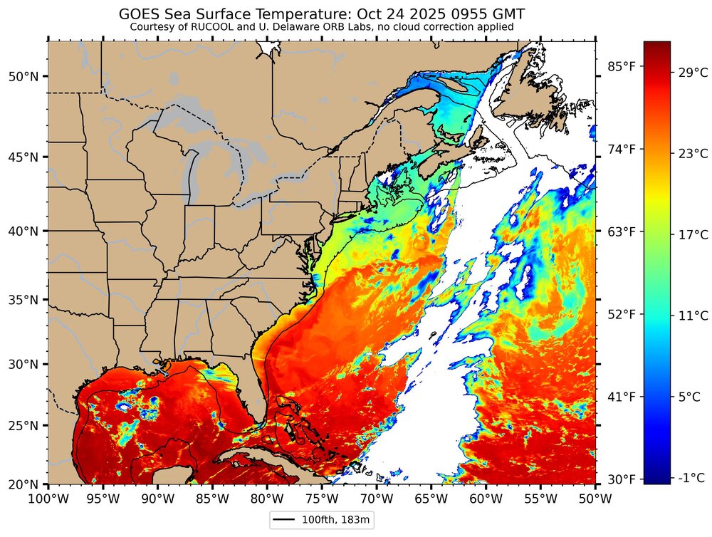
-
Spooky Season (October Disco Thread)
jbenedet replied to Prismshine Productions's topic in New England
GWDLT 41/39 for a low here… -
Spooky Season (October Disco Thread)
jbenedet replied to Prismshine Productions's topic in New England
The NHC also isn’t biting on the quick escape east track for Melissa. Right now, if Melissa misses it appears consensus is because of a poor phasing; and not the GFS scenario. -
Spooky Season (October Disco Thread)
jbenedet replied to Prismshine Productions's topic in New England
The 6z GEFS was a pretty sizable shift towards the EPS with higher mid level heights over the western Atlantic . -
Spooky Season (October Disco Thread)
jbenedet replied to Prismshine Productions's topic in New England
Great drink here today. 1” in view… -
Spooky Season (October Disco Thread)
jbenedet replied to Prismshine Productions's topic in New England
Lawns and shrubs looking best they have all year. Another recurring theme…will see this through thanksgiving. -
Spooky Season (October Disco Thread)
jbenedet replied to Prismshine Productions's topic in New England
Warm/wet cool/dry Familiar…. -
Spooky Season (October Disco Thread)
jbenedet replied to Prismshine Productions's topic in New England
On the cross sound ferry into New London. Don’t even need a sweatshirt on the top deck. Awesome out. -
Something else that’s often lost on these hybrids is that the magnitude of impacts are often dictated by the strength of the surface high; not the min SLP. The surface high has been very gradually strengthening with time on guidance.
-
The current display off the coast of Florida is impressive. Really wouldn’t think this amounts to a 1000mb low over OBX. I think it doesn’t fit the calendar wrt hurricane season. It’s not the bet to make—that this ends up much stronger than guidance consensus—but it’s something to watch closely.
-
Spooky Season (October Disco Thread)
jbenedet replied to Prismshine Productions's topic in New England
Like clockwork our early fall frost in line with climo only to see the +20 anoms return in second half of fall. -
Spooky Season (October Disco Thread)
jbenedet replied to Prismshine Productions's topic in New England
I’m also at a local max elevation in the downtown area so that may be playing an important role as well. Top of a “hill” as subtle as it may be. Important on mornings like this… -
Spooky Season (October Disco Thread)
jbenedet replied to Prismshine Productions's topic in New England
This is a really fake cold. I’m not seeing much at all evidence of frost but on the cars. The air feels frost worthy however. It’s almost as though it only registered freezing because of a complete stillness of the air. Even slightest mixing, and we would be well above. The immediate ground surfaces and shrubs appear to have too much residual heat from the recent rain and 80 degree temps to affect. -
Spooky Season (October Disco Thread)
jbenedet replied to Prismshine Productions's topic in New England
There is also an interaction with TC Jerry to watch. Very dynamic setup overall. Nice break from the boredom. -
Spooky Season (October Disco Thread)
jbenedet replied to Prismshine Productions's topic in New England
GFS is warm core. With origins in northern Bahamas in the 7th inning of hurricane season—not a surprise. Baseline expectation should be sub tropical type system forming. -
Spooky Season (October Disco Thread)
jbenedet replied to Prismshine Productions's topic in New England
70/60 Just walked the dog with t-shirt shorts and sandals. -
Spooky Season (October Disco Thread)
jbenedet replied to Prismshine Productions's topic in New England
This is an overall odd distribution on a line CON on north. No clouds anywhere in the region. I mean, not only are the + anomalies the greatest but the temps are also warmest… Makes me think that leaf drop and/or completely dead leaves still on the trees on points north vs points south maximized the atmospheric potential by getting the most out of ISR through both less shade and evapotranspiration affects.