jbenedet
-
Posts
7,691 -
Joined
-
Last visited
Content Type
Profiles
Blogs
Forums
American Weather
Media Demo
Store
Gallery
Everything posted by jbenedet
-
Today’s progged highs will easily be exceeded. Upper 40’s in view for many.
-
There’s a lot of support for that look. La Nina (Jan), the EPS and GEFS forecasts for the NAO teleconnection are also aligned for deeply negative. The op runs signaling similar. Start worrying.
-
It matches the teleconnection forecast. Not good.
-
Yea this is kinda where I’m at, especially with peak winter climo a few weeks away. NYC metro close enough to watch with keen interest…
-
The cutter will wipe anywhere that doesn’t fall below freezing tonight. Probably the usual line cutting through DAW and N ORH to just north of PWM…
-
This isn’t what we want for the bulk of New England. Seasonal cold and dry, especially in northern New England. Once this -NAO gets entrenched it could even result in N, to AN in Northern and eastern sections of New England. In a La Niña this is something we should be vigilante against as tendency into January is dry up here. The main takeaway is this will send most storm tracks south. I’d be watching intently in mid Atlantic, down to Virginia.
-
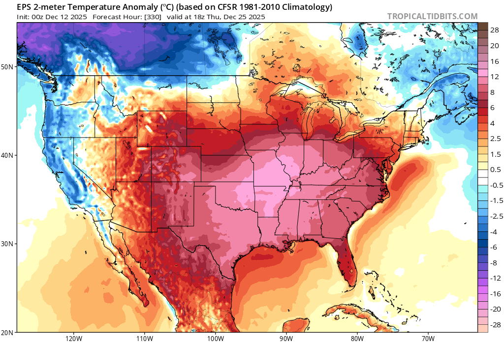
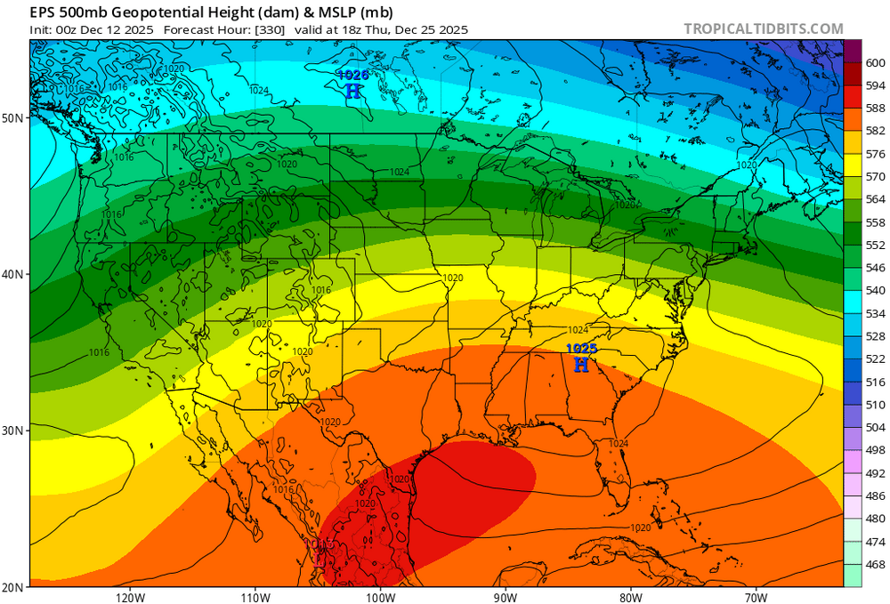
Euro with 978 mb in southern Ottawa. 61 is record high for the date here. They will be under threat regionally Should be taking notes that all of our big storms have been cutters. From someone who only wants big snowstorms, and seasonal cold. This is pattern is trash.
-

December 14th - Snow showers or Plowable snow?
jbenedet replied to Sey-Mour Snow's topic in New England
Bc it will be gone by Thursday, and the SNE region up to seacoast NH, Boston and Portland will be tracking less than half climate average snowfall through Christmas. But sure “optimism”. Snow colored glasses and chest pounding from 40/70 too. Good luck with the blogspot. It’s been so bad that 4” gets the attention of DCer’s around here. -
That looks like heavy snow in western queens/nassau right now. ~35 dBz Congrats. Don’t think any major metros up to Portland Maine have seen that this season.
-
Moderate snowfall 12/14/2025 WWA up for most of the area
jbenedet replied to WeatherGeek2025's topic in New York City Metro
It’s a narrow band of frontogenesis. Sinking/subsidence just to the north. Another way to put it is the stronger the band, the worse the subsidence in areas just north of it. Have and have nots right across the sound. Not an exact forecast here but from a conceptual standpoint it’s a case where commack LI could see 6” and north haven CT, 1.5”. The modeling likely underdone on the gradient (delta). -
Moderate snowfall 12/14/2025 WWA up for most of the area
jbenedet replied to WeatherGeek2025's topic in New York City Metro
I would NOT be using this rationale to go lower. They will lose on that. Looks good for 99% snow. -
It’s beginning to look at lot like torchmas…everywhere you gooooo
-
December 14th - Snow showers or Plowable snow?
jbenedet replied to Sey-Mour Snow's topic in New England
Can’t wait to head to Sey’Mours with my leaf blower Clear his 1” —-days and days of brown. -
Good luck.
-
CAD without a cold airmass is…. Relatively warm northeast flow. Welcome to life away from your computer.
-
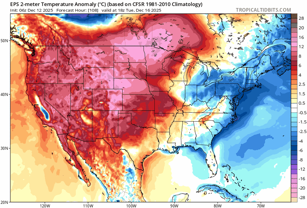
The -NAO look some are desperately banking on is also completely absent cold air in southeast Canada. It’s all in the west. And easterly flow is off >45F SST’s. It’s a complete losers bet to expect N to BN during that window. You’ll avoid a torch but still yield +5
-
It’s worth recognizing… You’re a fool.. Even with the coldest Ensemble runs of the EPS for that date, it’s still warm. A loser taking a losing bet. Shocker. That incredible warmth is 250 miles away; the deep cold is 2500 miles away…Take your bet… Some critical thinking is worth something.

-
See more snow…than anything I’ve seen observationally or guidance wise. Everything indicating negligible chance of a white christmas near you. Plan for brown, sey-mour. 1” snow chance on 12/14 followed by a week’s worth of cutter threats. As if that wasn’t enough, the 24th/25th continue to look the warmest on the ensemble guidance…
-
I’m convinced you guys don’t go outside at all and look at the world around you. Sad. “Meteorologists”— just model junkies tied to computers with no bearing of observations.
-
No it’s more than that. Past three day we’re running like 5F-7F colder. As I said, there’s been a very significant seasonal gradient persistent for more than just one storm/pack. Highs past three days: PSM: 23, 34, 36 Islip NY: 36, 45, 46
-
Pretty remarkable differences in look and feel from PSM down to eastern LI. snow blowers and ice melt vs green grass and leaf blowers. Traveling 150 miles looks and feels more like 600. It’s November to the south, early January to the north. For my location, it means winter’s grip, currently, isn’t that strong at all—warm sectors will not be strongly defended against… The referenced map is more than just what the last storm brought. There’s a completely different seasonal vibe north/south of that line.
-
I agree in the far interior. Especially NNE. Warming from climo norms is actually conducive to more snowfall. We’ve seen it recently. Dry is the bigger enemy up there. But I do think in large chunk of SNE/CNE up along coastal NNE this is an important trend.
-
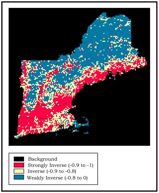
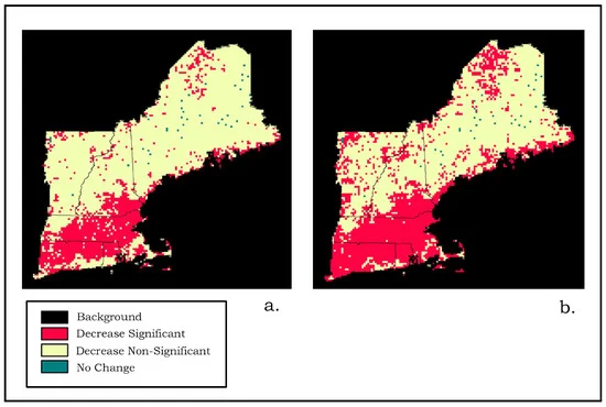
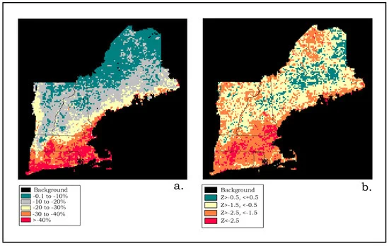
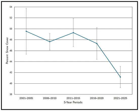
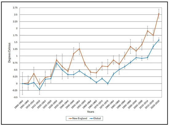
Mods could move this where it needs to go, but this read was extremely informative for our region regarding CC. Another analysis indicating New England is fastest warming region, right along side the arctic. It also corroborates the observations we’ve had that this warming is accelerating. https://www.mdpi.com/2225-1154/13/12/246


-
This weather is the worst. It’s the inverse of 110 heat index. Then the only great place to be is a pool…. Now the only great place to be a is a fireplace. Extremely limiting on daily activities. Even well maintained things, break or fail… If you like this weather you should move to where the cost of living is sooooo much cheaper than New England.
-
This is a fantastic read on CC if you live in the New England area. https://www.mdpi.com/2225-1154/13/12/246