jbenedet
-
Posts
7,710 -
Joined
-
Last visited
Content Type
Profiles
Blogs
Forums
American Weather
Media Demo
Store
Gallery
Everything posted by jbenedet
-

January 2026 regional war/obs/disco thread
jbenedet replied to Baroclinic Zone's topic in New England
SNE talking about black ice like they live in DC. Exciting times. -
January 2026 regional war/obs/disco thread
jbenedet replied to Baroclinic Zone's topic in New England
38/29 at 8:30 am. And the black ice throughout downtown is finally gone. perfect for the morning dog walk.finally. rejoice. -
January 2026 regional war/obs/disco thread
jbenedet replied to Baroclinic Zone's topic in New England
PSM hit 49 last night. Gotta be the warmest temp in 3 weeks. Maybe a month… -
January 2026 regional war/obs/disco thread
jbenedet replied to Baroclinic Zone's topic in New England
At least the GFS lost its “congrats OBX” BS for the 16th. It’s now rightly back in line with all other major guidance. So how this will evolve is a lot clearer than earlier today… -
January 2026 regional war/obs/disco thread
jbenedet replied to Baroclinic Zone's topic in New England
15th/16th—That GFS run is very -NAO ish I don’t buy this evolution. Looks like a step further away from reality. The NAO forecast had another stepwise increase well into positive territory before our players are on the field..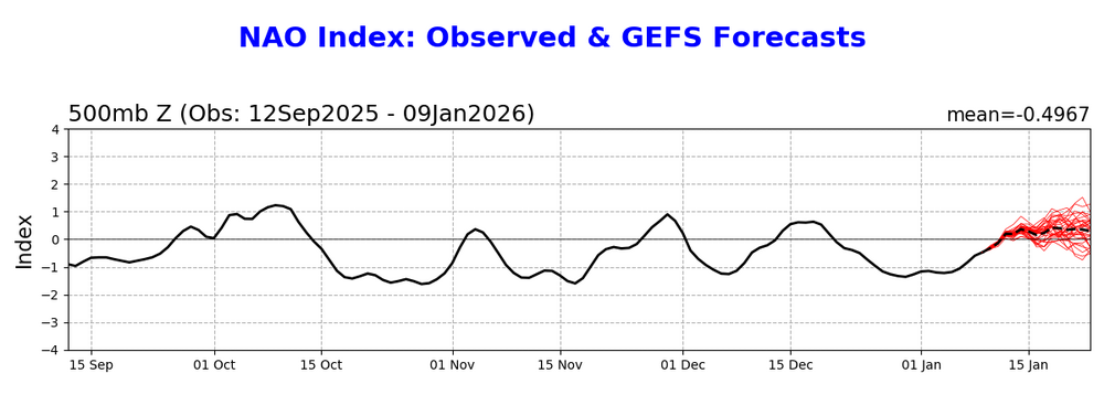
-
January 2026 regional war/obs/disco thread
jbenedet replied to Baroclinic Zone's topic in New England
Ugh. That’s so wound up it’s gonna interfere with the follow up wave… That one I like for the better long wave placement… But that’s another potential issue gotta watch now… -
January 2026 regional war/obs/disco thread
jbenedet replied to Baroclinic Zone's topic in New England
Yea these winter days are good. So important. Today’s got a great vibe 37/31 -
January 2026 regional war/obs/disco thread
jbenedet replied to Baroclinic Zone's topic in New England
Good point. To be sure I’m thinking most commonly 43-45 readings, for the region. a solid +10 today Dews will also be rising all day so it will compound the real feel. Legit warmth on this merit as well… Gotta get outside… -
January 2026 regional war/obs/disco thread
jbenedet replied to Baroclinic Zone's topic in New England
Agreed on the sun. But atmosphere is cooked just above the surface. -
January 2026 regional war/obs/disco thread
jbenedet replied to Baroclinic Zone's topic in New England
NAM laughably too cold for surface temps today… These clouds are breaking… widespread mid 40’s easy and 50 within reach at many spots in SNE. -
January 2026 regional war/obs/disco thread
jbenedet replied to Baroclinic Zone's topic in New England
I’m just talking widespread warning level snow. Thats what my odds are against. … -
January 2026 regional war/obs/disco thread
jbenedet replied to Baroclinic Zone's topic in New England
predictions made with present data. Not making predictions based on the data changing…no evidence for that. Always the case. But looking at the large scale features and the agreement on them across important guidance at this stage…. It’s very low odds of a big snowstorm. My take. -
January 2026 regional war/obs/disco thread
jbenedet replied to Baroclinic Zone's topic in New England
Looking at 6z EC AIFS - I don’t like it…. The early mid level cut-off in northern stream is another red flag. You’re going to get much more shunting east with the coastal than meridional mid level ridge development can compensate for over the western Atlantic. Maybe a cape scrape? I’m focusing on the 18th… -
January 2026 regional war/obs/disco thread
jbenedet replied to Baroclinic Zone's topic in New England
There’s red flags with that euro run. Mid levels look juicy but beneath you can see the BZ is not at all where we want it. we’re actually between two zones, one indicating it’s taking the surface reflection well ots whereas the other well to our west and indicating warm sector/ptype issues. I’m maintaining I do not like this one at all. It’s a lot further from where it needs to be for a significant snowstorm than the 6z euro mid level depiction is reflecting.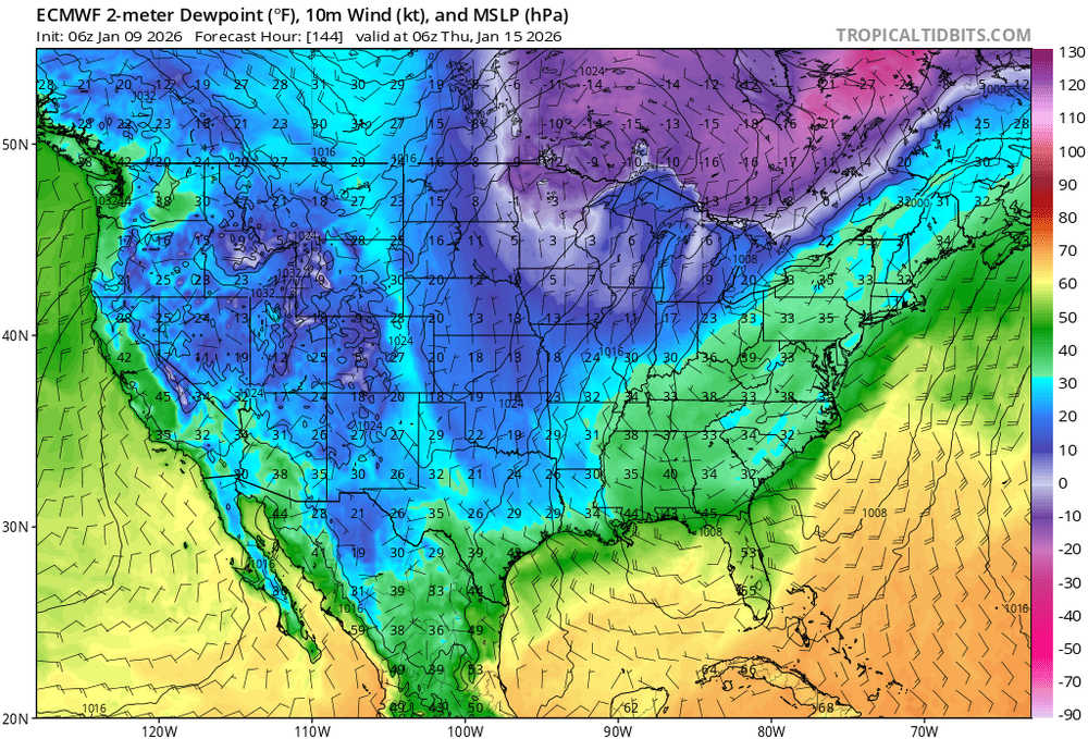

-
January 2026 regional war/obs/disco thread
jbenedet replied to Baroclinic Zone's topic in New England
On the 15th The GEFS evolution matches the EC-AIFS now. it’s ugly. Mostly northern stream. Not wanting to synch with southern stream… Sell a nor Easter -
January 2026 regional war/obs/disco thread
jbenedet replied to Baroclinic Zone's topic in New England
46/32 Great to finally get the ice off the driveway. Some 2 weeks of this… -
January 2026 regional war/obs/disco thread
jbenedet replied to Baroclinic Zone's topic in New England
We have not had one fun storm to track… Just hella cold. Need I mentions the other “benefits” of this crap Pattern— Heating bills up ice melt use up slips trips falls up doggy depression up boredom up -
January 2026 regional war/obs/disco thread
jbenedet replied to Baroclinic Zone's topic in New England
Even a ratter is better than rotten… -
January 2026 regional war/obs/disco thread
jbenedet replied to Baroclinic Zone's topic in New England
I’m up to 34, skies brightening and melting starting… -
January 2026 regional war/obs/disco thread
jbenedet replied to Baroclinic Zone's topic in New England
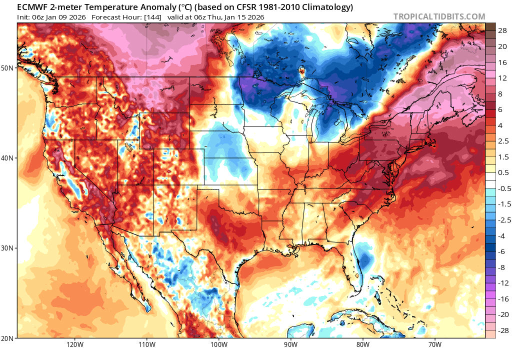
Doesn’t matter — the GEFS run surface anomaly output tells you this isn’t an icing setup at all. Not even close. -
January 2026 regional war/obs/disco thread
jbenedet replied to Baroclinic Zone's topic in New England
-
January 2026 regional war/obs/disco thread
jbenedet replied to Baroclinic Zone's topic in New England
The big ridge out west and trough to the northern gulf will happen, but we have to watch the western Atlantic for too much ridging—speaking for the southern 2/3 of the forum… -
January 2026 regional war/obs/disco thread
jbenedet replied to Baroclinic Zone's topic in New England
Dover with 0.01” since midnight. And nothing upstream incoming… Bust. -
January 2026 regional war/obs/disco thread
jbenedet replied to Baroclinic Zone's topic in New England
Worst icing of this event are points south in SNE/CNE. Even the batch in western MA will miss my area to the south, later today. -
January 2026 regional war/obs/disco thread
jbenedet replied to Baroclinic Zone's topic in New England
Temperatures conducive but no precip. NWS forecast 0.1 -0.2” ice. Ain’t happening. 0.03” at PSM. DAW seems to be having issues but they must have also registered 0.03” or less through the morning….