jbenedet
-
Posts
7,815 -
Joined
-
Last visited
Content Type
Profiles
Blogs
Forums
American Weather
Media Demo
Store
Gallery
Everything posted by jbenedet
-
Going long wet bulbing not the way to win a forecast with warm onset and easterly fetch. 12z NAM showing temp around 34 with td 32/33 tonight at least during first few hours. Not a recipe for stacking.
-
Winter storm warning here?
-
The best rates look at onset and some of the short term guidance is flagging a loss to rain or white rain before transition to accumulating snow. Another reason to hedge against the 5”+ amounts
-
Radar looking like it starts around 1pm here Earlier than progged start times do happen with these but jeeze…
-
I’m taking the under on this one. It’s evolved from the 6” type scenario with good coastal transfer, and mostly a SWFE with weak players all around - surface high, primary, secondary are all weak… It’s also a much more progressive scenario — short duration. Ratios look 10:1 at best also. I’m going 3” here and calling it a day.
-
And yet didn’t come close to the all time records. To me we've just seen the new rock bottom in temps for this part of the world. The antecedent significant cold was one ingredient. The second being that this airmass had no mitigating factors on its way to NY. The only offset was that it originated over a much warmer 70N+…
-
 Agreed. Probably*
 -
Yea I was talking duration. I know they do -10’s. It’s a cold climate. Let’s see if it can -15.
-
I’m aware. so it is as records go… Will need to look at this in terms of hours sub zero just to scale it.. No idea on the history for Binghamton.It just seems incredibly impressive for this part of the world..
-
I’m seeing that Binghamton may not crack zero all day tomorrow either. Air temperature…. I don’t know what that means historically but that’s wild to me.
-
We -NAO Need to be west for the serious cold.
-
To our west? Yes. West of CT river is probably coldest in a few years. That’s relevant for here. But NY NJ and PA are challenging records.
-
Somebody’s nervous… NYC is below 6F, by midnight tonight.
-
Arctic is a big place— 60N +. This is the top of the planet.
-
Airmass straight outta the North Pole. Sure it’s been sampled very well by the Inuit and polar bears.
-
It’s gonna be damn near close if it isn’t.
-
I wouldn’t go that low bc of the wind. My bet is around 0
-
The record level cold is to our west. It’s run of the mill here. Guidance is still getting colder in NYS. Watch those 850s
-
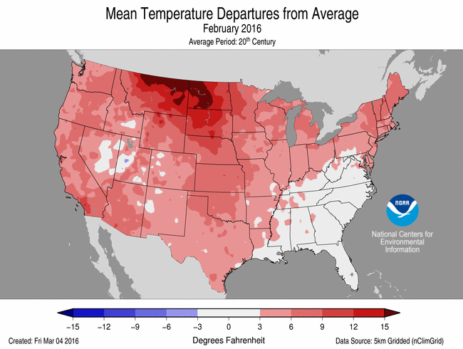
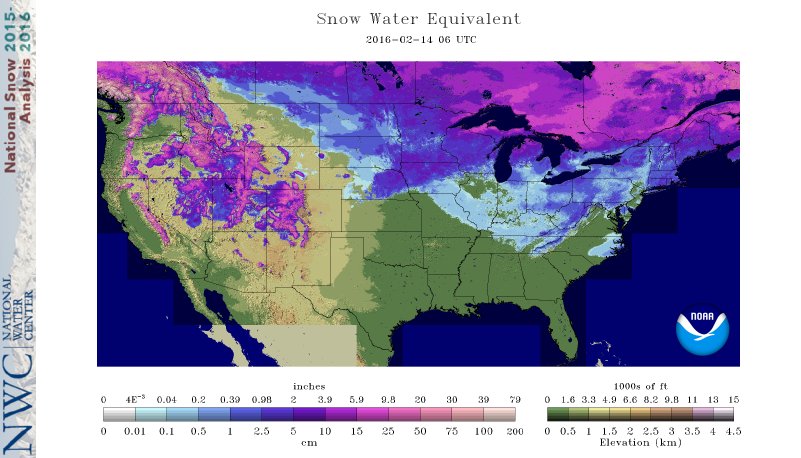
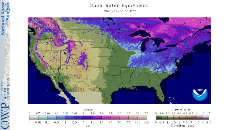
Guy is laughing but making direct comparison to February 14 2016… 1) Significant El Niño year. 2) significantly above average month temp wise in northeast. 3) significantly less snowpack in the northeast. 4) the Great Lakes were less than 10% ice covered. Using MOS verbatim for this makes little sense given how cold this year has been vs historical norms.
-
Also seeing that latest guidance keeps areas like binghamton, Albany and Syracuse NY sub zero all day Saturday… Good luck infrastructure….
-
Sunday morning looks coldest in NYC metro most have seen in their lives… Once in 50 year level potential with this. 0F in CPK is conservative. The bias is to take UHI and +5 vs guidance but the in situ cold and winds will mitigate those affects. Very relieved personally that the axis of cold is about 250 miles west of here. Binghamton NY flirting with -20F before wind chill is holy shit level cold for our latitude.
-
The cold doesn’t give a shit about latitude this year. It’s been frickin cold this winter. Feel that even Bangah Maine’s climate is warmer against what I’ve been experiencing. Closer to Montreal lately…Unreal.
-
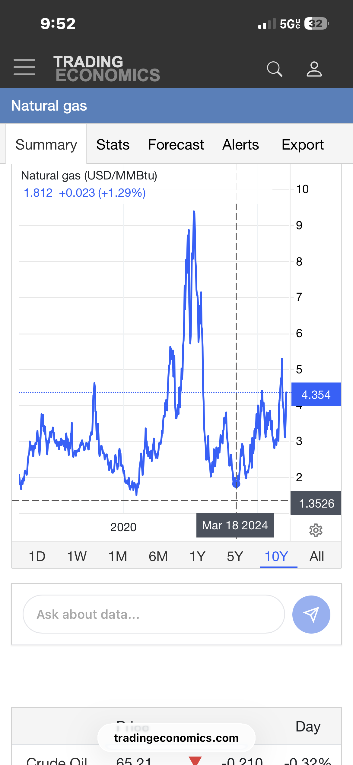
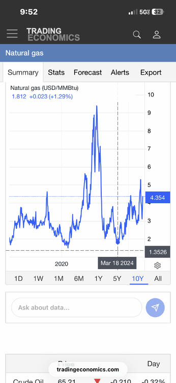
You could run circles around me about the short term stuff. I don’t do day trading. Not for me. I’m big picture. I do well short term only when I zoom way out. There was a major bottom put in, in early 2024. It’s a bull mkt now. The producers basically went no where since early 2022, following the major price decline. But nat gas is in a strengthening bull market…Thats what got me most interested. The recent cold was icingon the cake.
-
No idea about the specifics correlation or lag. I just know the correlation is meaningful and positive. I started looking more at the sector seeing the cold snap caused the price of nat gas to move way up but the big producers didn’t follow likewise. I then dug a little deeper and saw evidence in the long term price behavior of the major producers that people are rotating into the sector—building positions. Of the group, CVX chart looked the best to me. I also believe natural gas is in a long term uptrend. The recent cold snap was just adding fuel for a breakout.
-
Possible coastal storm centered on Feb 1 2026.
jbenedet replied to Typhoon Tip's topic in New England
-NAO vibes My thinking remains that this aspect will improve from here on out given the forecasted teleconnections. But. Will it be enough to outweigh the interference from the trailing shortwave. That’s the main limiting factor in my view… A few days ago I thought guidance would be in a better position at this juncture considering these factors, so I have to take ceiling way down right now outside of the cape.