jbenedet
-
Posts
7,815 -
Joined
-
Last visited
Content Type
Profiles
Blogs
Forums
American Weather
Media Demo
Store
Gallery
Everything posted by jbenedet
-
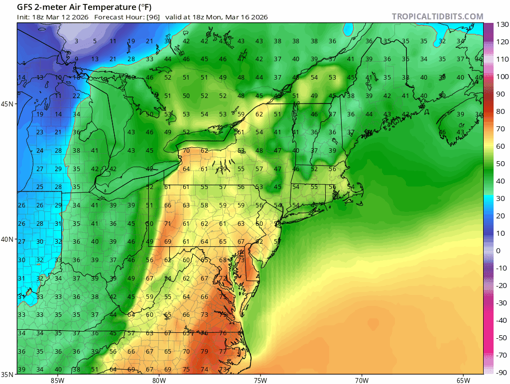
We look good for persistent AN next week as we move to April. MJO phase 1/8 tendency which we’ve had a lot of flips to AN bias in early spring. The EPS is already saying the same. That will feel really nice. A very nice early April for a change.
-
Not even a dusting here. Vast majority of people around here won’t know even a flake has fallen. Bust on the advisory…
-
60 sounds about right.
-
Expecting wake up to dusting of glop to white rain to rain.
-
Really? 80”? Damn didn’t realize we were that high.
-
-5 persistence in DJF to +2 persistence in March. I’ll take it.
-
This month was the easiest forecast in a while. Persistence + jet 300 miles north due to seasonal progression.
-
Picked up sooooo much dog poop past two days. This rain will work as the backyard cleanse.
-
Wondering if I can pull a 60 dew
-
58/56
-
I would start shootin’ rounds into the snow and sky. Eff that shit
-
Feeling very lucky this storm waiting for a week of melting before hitting us….
-
39/37 Rain. Temps stayed up all night as expected. Continued thaw and melting overnight of the of piles into 60 degree temps tonight should wipe it all out, outside of the parking lots.
-
37/27 Guidance is too cold tonight. Dont see temp moving much at all from here on overcast skies and persistent SE winds. Dews will trickle up all night…temp constant.. We’re gonna be left with just the parking lot piles after this storm.
-
Sun is winning here at the moment. Gonna be a fight all day but currently mostly cloudy and fair weather bright conditions…
-
Will live or die by the overcast here today. A crap day or a decent day if there’s consistent breaks. It is very thin and sun beating through but still shrouded. In the east, we have a chance a mostly cloudy…we’ll see.
-
Give it a rest. Posted like 30 times this morning for boredom and 1.5” of snow.
-
Pretty much every bird in Dovah is active this morning. Spring is here. Overnight 1.5” of glop with melt commencing at sunrise fits the bill.
-
Not a flake Zzzzzzzzz
-
I don’t know what people’s expectations are but this weather is pleasant for the calendar. Full sun and light winds the real feel is fine for the long morning walk with the dog.
-
Normal temps behind the “cold” front noice.
-
Not even a flake here Radar full of lies.
-
Post this on your wall.

-
@Snowcrazed71 is all about the torch
-
48/38