
CAPE
-
Posts
36,419 -
Joined
-
Last visited
Content Type
Profiles
Blogs
Forums
American Weather
Media Demo
Store
Gallery
Everything posted by CAPE
-
Looks like a slow moving front that may ultimately stall/dissipate somewhere in the area. Pretty good setup for several rounds of convection.
-
^I got partially ninja'd on that post.
-
After a high of 85 yesterday with low dews, looks like another nice day today. Not a 90 in my forecast until Saturday. Looks like the "big heat" will have to wait until next week. As of now, early next week looks pretty sultry- probably mid 90s for urban areas with dew points in the 70s.
-
We only care about the NAO during the winter, so this historical series gives you a good idea of the long term values. NAO has been predominately in the +phase during the winter months over the last 50 years, with generally more instances of strongly positive episodes in winter compared to prior periods. With the recent unfavorable trends in the Pacific patterns during winter, we might be phucked in the MA for awhile. Go north. None of this stuff matters much relative to cold and snow up in NH.
-
Should be pretty nice for cutting up the tree blocking the driveway when I get home from work later. Luckily the main part of the tree is laying just off the driveway. I will probably just leave that for now and cut and split it in the fall. It's one half of a pretty large double trunk tree and sheared off right at the base.
-
Yesterday there was poor model agreement on the timing of the shortwave energy rotating through and the front itself. It looked like today was the better day for possible isolated severe. Seems it came together late last night/early this morning for eastern areas. The front has already moved through and we should see drier air filtering in with minimal chances for a shower today.
-
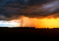
Well here is most of the damage. Lots of other scattered branches and debris too. My wag is the wind was in the 60 mph range.. I wasn't expecting even a garden variety storm so needless to say this was a big surprise. It didn't last long but it was impressive.
-
That was a quick one. Tree debris all over the deck. I am sure I will be moving some branches off the driveway heading out tomorrow morning. 0.14" in the rain gauge, but it was sideways so likely was a bit more.
-
This storm is a banger. Booming thunder, Worst wind I have seen in a long time. Legit scary here in the woods.
-
Is something like that even meteorologically possible anymore?
-
I actually ran the sprinkler a bit this morning lol. I spread a dry fungus/disease control product on the lawn yesterday, and wanted to get it working into the soil. Does most of the work at the root level.
-
Tomorrow looks pretty interesting, although models are kind of all over the place on the timing of the front, and overall not too impressive with storm coverage. Pretty decent shortwave energy will be rotating through, but the location and degree of convection probably comes down to timing. SPC does have much of the region in a marginal risk for tomorrow.
-
We are in the period of summer now where 'cold' fronts don't change sensible weather much. Typically as we get into September we can see a more legit front or 2 come through that actually provides more noticeable short term relief.
-
Sometime in September.
-
Yes indeed. It is definitely a localized marine influenced climate they enjoy there.
-
Low of 68 here this morning. Not bad out, yet.
-
It's been pretty ordinary heat in general. I am just guessing, but most of the 90+ temp days in DC during this run were probably 90-92.
-
Yeah it looks like we are going to have a weak Nina or a cold neutral during winter at this juncture. This is recent stuff, from a few days ago- https://iri.columbia.edu/our-expertise/climate/forecasts/enso/current/?enso_tab=enso-cpc_plume
-
^Easy to imagine how this will go. That EPAC ridge/downstream trough position looks precarious.. but a monster -NAO will save us this time! I wont bother posting it because it sucks beyond words, but the CanSIPS has the h5 look that will probably be much closer to reality, based on our recent run.
-
CFS has been on a "good" run lately with looks like these. No qualifiers necessary. We all know the deal with long range climate models.
-
Lets get this (pity) party started.
-
Imagine being a weather forecaster in SD. For those who just want 'ideal" weather all the time, probably hard to match the climate there.
-
We all go through it this time of year. Feast or famine. Learn to love that sprinkler. It is your very good friend.
-
Temp down to 84 here now, but still on the humid side. Air is moving a bit, so doesn't feel as bad as earlier.


