
CAPE
-
Posts
36,418 -
Joined
-
Last visited
Content Type
Profiles
Blogs
Forums
American Weather
Media Demo
Store
Gallery
Everything posted by CAPE
-
NAM
-
Yesss The first part of my post was a song reference, for those of you into folk- alt rock.
-
Not trippin' on hallucinogenics. Sippin' on a 120. Drink a few and there might not be much difference.
-
Low of 48 here
-
59 here. Forecast low here is 52. That may bust high, as there is no wind and the high altitude smoke particulate should not inhibit radiational cooling much if at all. We shall see.
-
Yeah I will go out on a limb here and guarantee my yard will see more than an inch, which was the total last winter(rounding up).
-
Gross. Head to Florida.
-
Damn, this is good.
-
Firestone Walker 2020 Parabola Barrel Aged Imperial Stout Bought it today with the intent of saving it for the weekend. However, in celebration of the awesome weather, its not gonna make it. Might be a weak excuse, but it didn't take much.
-
63 here. Fabulous. Damn mosquitoes need to die though. eta- DP is 46
-
It is in about the same spot above the horizon, different direction though.
-
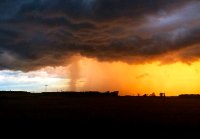
The sun looks the same as it did when I took the photo around sunset last evening. Pretty eerie.
-
Latest CFS runs continue to depict h5 +height anomalies over the high latitudes for late Fall into the first part of winter.
-
There is a bit of a trend over the last couple model cycles to bring the remnants of Sally further north. Might see some showers later this week for eastern areas ahead of the next cold front. And ofc the 6z 12km NAM now pummels the eastern third of the region lol.
-
51 here this morning.
-
Cool HP building southward from NY state will make today feel very fall like. Too bad we will still have particulate matter in the upper levels from the smoke. We will again see milky/hazy skies instead of what would be brilliant blue.
-
That map is ambiguous, and quite frankly, useless.
-
He has more weapons this year too, so no need to run as much. Andrews is still a beast, plus Hollywood is healthy, and as if we needed more talent at RB, I love Dobbins. Dare I say he reminds me of Emmitt Smith..
-
I was in the 4-10" area. Yeah 8" of wet snow at 32 degrees piled up here early on, but the second half of the storm was 40 degree driving rain. An historic storm for the interior for sure, esp the mountains.
-
Oh I agree. It was just a heavy wet snow to rain deal here though. Then all the waterlogged slush froze solid as the cold air came back in at the end. Probably not even a top 20 storm here as winter storms go. This is a MBY business, as we are all well aware of here.
-
Yeah like, why is Lamar still in this game?
-
Who woulda thunk? Being able to test on the reg. track, and immediately quarantine if needed is nice too.
-
Lamar doesn't need to run. He is dealin'.
-
Its different.


