CAPE
-
Posts
36,289 -
Joined
-
Last visited
Content Type
Profiles
Blogs
Forums
American Weather
Media Demo
Store
Gallery
Everything posted by CAPE
-
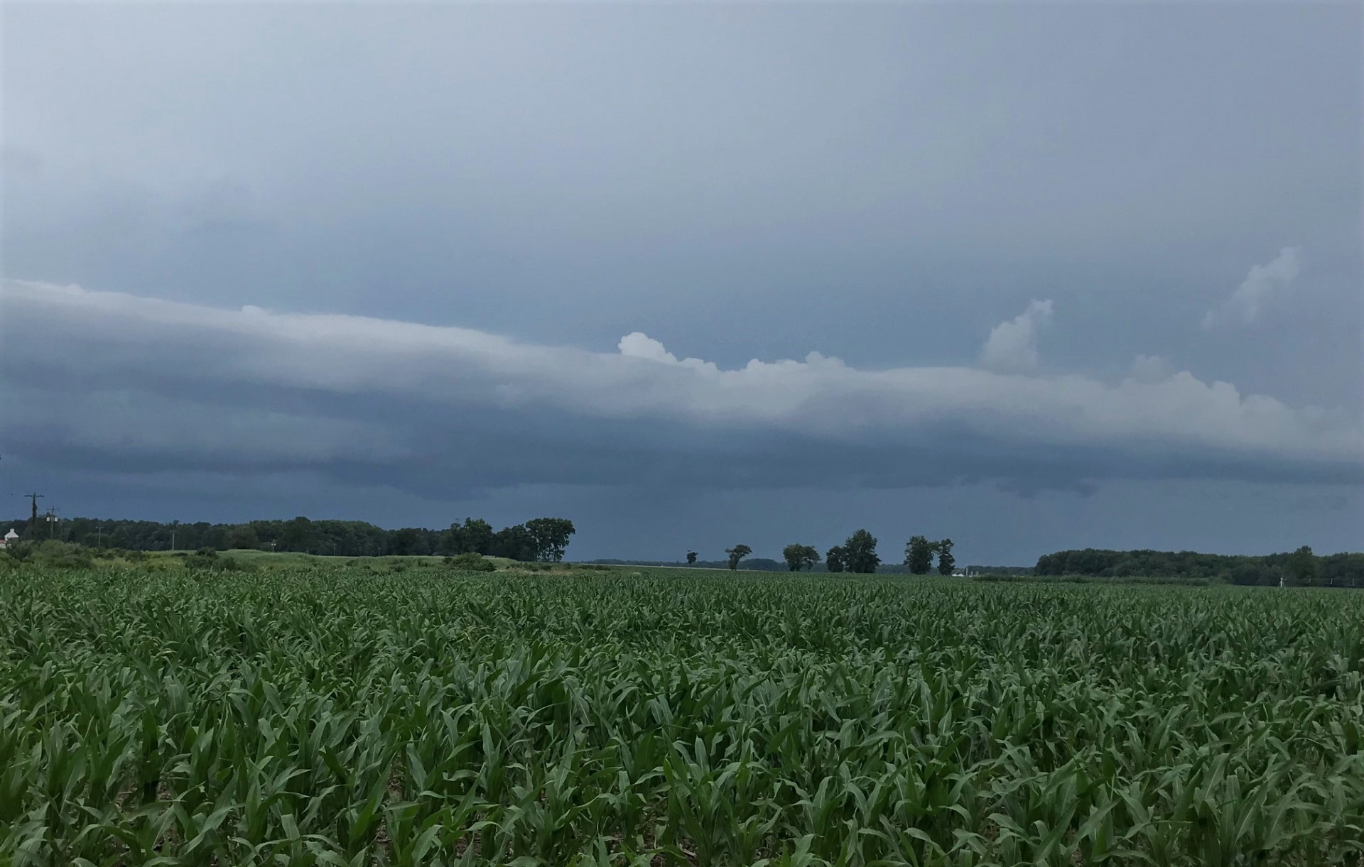
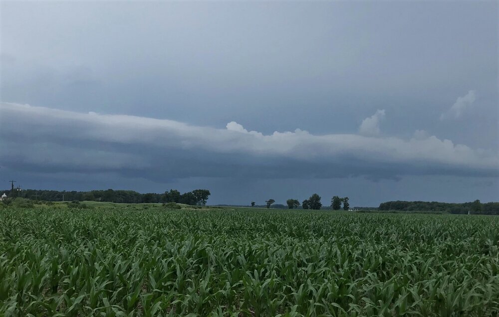
Shot of the western sky as the storm was ending.
-
1.21" total. Another line headed east towards the bay. Probably will weaken/slide a bit south.
-
This 'have not' became a 'have' finally. 1.10"
-
Best storm here since- April maybe? Torrential rain, gusty winds, and T&L. Nothing severe. Perfect.
-
Decent outflow boundary pushing ahead of the approaching line on radar. Lets see if this finds a way to fail here lol.
-
Incoming. Looks promising... couldn't possibly fail. Ahahaha.
-

2023 Mid-Atlantic Severe Wx Thread (General Discussion)
CAPE replied to Kmlwx's topic in Mid Atlantic
Definitely a bit of a hole here the last month. @WxUSAF- 2,785 replies
-
- 1
-

-
- severe
- thunderstorms
- (and 3 more)
-
2023 Mid-Atlantic Severe Wx Thread (General Discussion)
CAPE replied to Kmlwx's topic in Mid Atlantic
-
Not a drop yesterday. Picked up 0.03 this morning as a scrap from the better stuff just to my north and east. Recurring theme here. Looks like another chance for failure later lol.
-
2023 Mid-Atlantic Severe Wx Thread (General Discussion)
CAPE replied to Kmlwx's topic in Mid Atlantic
About what I'm expecting. Maybe one day I will have nice things, but probably not today.- 2,785 replies
-
- 1
-

-
- severe
- thunderstorms
- (and 3 more)
-
2023 Mid-Atlantic Severe Wx Thread (General Discussion)
CAPE replied to Kmlwx's topic in Mid Atlantic
Per radar loop it looks like it developed in eastern HoCo right along the Balt Co line, then really blossomed NE of there. -
Probably an indication of how deep their farm system is now. He kind of got "lost" in the overabundance of talent lol.
-
2023 Mid-Atlantic Severe Wx Thread (General Discussion)
CAPE replied to Kmlwx's topic in Mid Atlantic
Latest disco on the severe threat from Mount Holly- Deeper convection is forecast to develop to our west near a pre- frontal trough. The model forecast soundings indicate some discrete cells out that way should quickly consolidate into a convective line as it shifts eastward. An examination of model point forecast soundings indicate ample instability developing along with rather steep low-level lapse rates, and the mid level lapse are on the steeper side as well. The shear profiles are somewhat on the weaker side, however model soundings show some initial backed low-level flow with around 30 knots of shear. This would be enough when combined with strong forcing for ascent arriving for the risk for severe thunderstorms. Storms should organize into a line as it approaches our region with damaging winds and some hail the main threats. Given the backed near surface flow ahead of the line, cannot rule out some rotation within the eastward advancing squall line (QLCS) especially across Delmarva. CAM guidance shows convection quickly becoming linear, with even some hinting at strong outflow winds. Given the steep low-level lapse rates, downdraft instability (DCAPE) should be on the high side, which will enhance convective winds down to the surface especially associated with any forward surges in the line. With increased confidence in linear thunderstorm segments capable of producing damaging winds forming, the Storm Prediction Center now has much of our area south of the I-78 corridor in an Enhanced risk (level 3 of 5) for severe thunderstorms on Monday.- 2,785 replies
-
- 1
-
-
- severe
- thunderstorms
- (and 3 more)
-
2023 Mid-Atlantic Severe Wx Thread (General Discussion)
CAPE replied to Kmlwx's topic in Mid Atlantic
Pretty interesting sounding for here tomorrow evening on the 3km NAM.- 2,785 replies
-
- 2
-
-
- severe
- thunderstorms
- (and 3 more)
-
Wth is going on over your yard? Damn. Maybe check the calibration on your rain gauge lol.
-
Could use a little excessive here to get back towards normal.
-
This Sangria hits the spot after being outside in the steam bath.
-
Sultry.
-
2023 Mid-Atlantic Severe Wx Thread (General Discussion)
CAPE replied to Kmlwx's topic in Mid Atlantic
Day 3 Convective Outlook AMEND 1 NWS Storm Prediction Center Norman OK 0312 PM CDT Sat Jun 24 2023 Valid 261200Z - 271200Z ...THERE IS A SLIGHT RISK OF SEVERE THUNDERSTORMS FOR THE MID-ATLANTIC STATES AND CAROLINAS... AMENDED FOR EXPANSION/UPGRADING OF SEVERE PROBABILITIES IN THE MID-ATLANTIC AND SOUTHEAST ...SUMMARY... A severe threat is expected to develop on Monday from the Carolinas into the Mid-Atlantic, where damaging winds and hail will be possible. An isolated severe threat will also be possible in the northern High Plains. ...Amended discussion for the Eastern U.S.... A mid to upper-level low will meander slowly eastward over the central Great Lakes during the period. An associated trough initially over the OH Valley/southern Appalachians is forecast to gradually shift eastward into the central Appalachians/Carolinas. A belt of moderate southwesterly 500-mb flow (25-40 kt) will overspread a destabilizing warm sector ahead of a front/composite outflow over the Appalachians. Strong heating ahead of the front and very moist low levels (66-74 deg F surface dewpoints) will likely result in a moderate to very unstable airmass from the Southeast northward into the Mid-Atlantic states. Several linear clusters of intensifying thunderstorms are forecast to develop by early afternoon in the immediate lee of the higher terrain. Further upscale growth into a more expansive band of linear segments is expected by late afternoon/early evening from the Mid-Atlantic states southward into the Carolinas. Damaging gusts appear to be the primary hazard due to 50-70 mph gusts. Isolated large hail may accompany the stronger cores.- 2,785 replies
-
- 4
-
-

-
- severe
- thunderstorms
- (and 3 more)
-
Managed to pick up 0.02" with that batch of spits and drizzle- the daily total. Probably it for the day as the action to the west is weakening. Up to 0.45" for the event.
-
It's just the nature of how we get rain now, and going forward over the next couple months. The haves and have nots- and that can run in streaks.
-
Drizzle . The rain gauge reads 0.00 for the day. Not mad- at worst I will have to water the newer plants probably on Sunday, with the likelihood Monday will also be a fail lol. The grass is oddly hanging in there, but it never makes it past early July regardless of the amount of rain that falls.
-
Your area has done really well lately. Looks like Middletown area has had at least 1-2" today. Your monthly total must be well over 5"?