CAPE
-
Posts
36,283 -
Joined
-
Last visited
Content Type
Profiles
Blogs
Forums
American Weather
Media Demo
Store
Gallery
Everything posted by CAPE
-
Yep sleeting here now. 34.5
-
just like the bust he smelled earlier
-
Finally getting some precip here even if it is rain lol. Temp 35
-
36 and dry here. Had a brief sprinkle a couple hours ago and that's it so far.
-
This was modeled and expected. Just giving the obs.
-
temps on the rise here. Up to 37.
-
We did well 2 weeks ago. This event favors NW areas. An inch or 2 or if everything goes right maybe 3 here.
-

Southern MD / Lower Eastern Shore weather discussion
CAPE replied to PrinceFrederickWx's topic in Mid Atlantic
Its pretty much wait and see how things develop now. If we get some decent rates this evening, 1-2 seems doable for Easton. If the 6z GFS is to be believed, maybe to 3 or 4. Lower shore is a bit more uncertain. I could see coastal DE getting a few hours of pretty good snow on the back end. -
Perfect. Once precip starts there temp drops quickly to freezing.
-
Same. Cover the bare spots and give the existing stale snow cover a fresh look.
-
Ofc. You always make this post inside of 12 hours from start time.
-
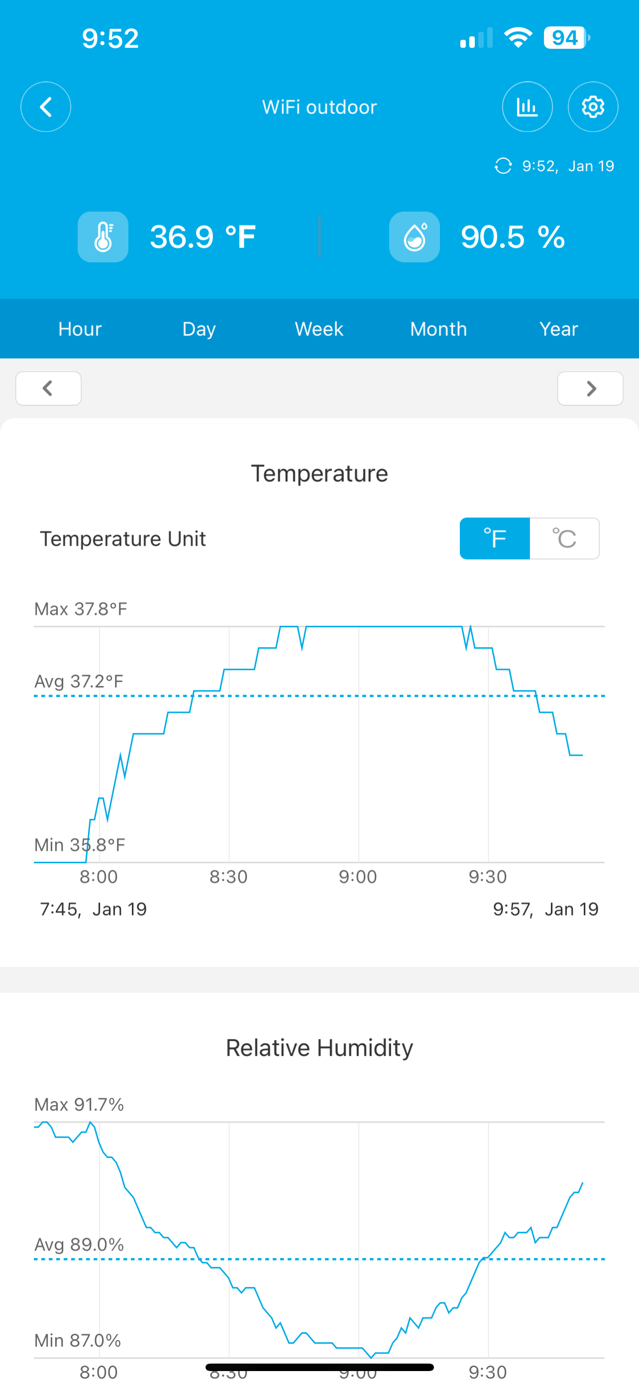
Its a bit colder over here. The 3 nearest stations to me are 33-35, and mine is 34 currently. Probably doesn't matter much. Temps will rise a few degrees here as onset approaches, while places further west that are in the upper 30s have hit their high and temps will drop from there.
-
The NAM is too cold though.
-
Onset of precip is a bit delayed on latest runs. Just focusing on my area ofc, but the duration of non-snow ptype doesn't seem much different for here. 3" is probably boom here. 1-2 seems reasonable.
-
Oh jeez Panic thread still open?
-
There hasn't been any real change over the last 4 model cycles wrt temps at onset of precip here per the GFS and EURO. 36-37, and 37 is the forecast high. NAM seems too cold. An initial period of rain/mix has always been in the cards esp for I-95 and SE. My biggest concern was lack of precip, but that seems less of an issue on recent runs. 34 currently
-
-
6z Euro. Looks reasonable. PSU snow map.
-
35 at 6am
-
6z GFS Nice run but not buying the 5 here.
-
They suck and make adjustments towards the preponderance of guidance at the 11th hour. No credit given.
-
30 here
-
Euro+GFS+3km NAM > Canadians Anyway still about 80% snow cover here. Hoping for a few inches to freshen up the snow and fill in the bare spots before the Arctic onslaught.
-
But no one cares what the RGEM thinks, ever lol. Or at least they shouldn't when the better models are in the other camp.