All Activity
- Past hour
-
 Smelling smoky now
 -

2025-2026 ENSO
40/70 Benchmark replied to 40/70 Benchmark's topic in Weather Forecasting and Discussion
Pretend I just injected you with truth serum....say the EURO had just come off of the presses with a HUGE southeast ridge, vortex over AK and about a +5 anomaly thoughout most of the NE....would you honestly be shifting the topic to the inaccuracy of seasonal models? -
 September despite the earlier sunsets has some of the best weather around here
 -
 81 / 67 here.
 -
Thursday should clear out nicely - smokewise too hopefully. The clouds part of the issue is rapidly clearing now but the smoke/haze is horrible. Back part of the clouds cover to EPA. Hazy sun by noon.
-

Mountain West Discussion
mayjawintastawm replied to mayjawintastawm's topic in Central/Western States
Glad I was on the East Coast. We finished July with 0.30" rain total at my house. -
Some better images off WxBell posted in the MA forum.
-
 It's not like the first half of regular fall is cold. Why wouldn't you want 70s for highs and lower dews compared to the crap we usually get now in summer?
 -
Some of my favorite places. You can even rent a little boat next to five island lobster and putter around. Reid State Park is spectacular.
-
 The satellite images from Sacrus show clouds. Yes there is smoke too, but overall it has been a mostly cloudy sky
 -
Was at the beach yesterday and the water was very, very warm. Also, the surf was rough with a NE wind that changed to Southerly in the afternoon, waves were messy, hard to ride with mostly onshore flow. The good thing was no jellyfish were sighted at North Wildwood.
-
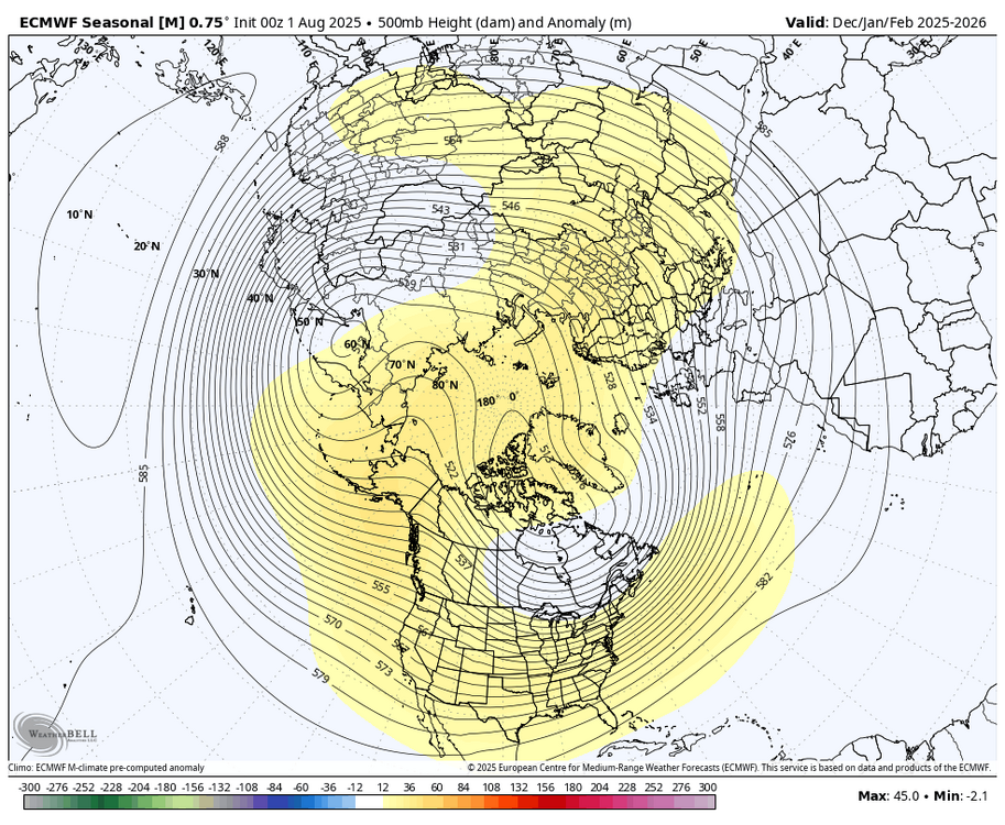
I think the last time the Euro seasonal had reasonably good winter forecast from October was 21-22. The forecast from August 21 was a miss. During the October forecast it got the idea of the -PNA correct for December. But the magnitude of the warmth and -PNA depth was way underdone. Probably related to the inability to correctly model the MJO beyond 1-2 weeks out. Then the January forecast was a miss since the MJO 8 wasn’t forecast beyond the late December period. February was reasonably close. Plus the 3 month mean blended together was OK. It wasn’t a mismatch type winter so it didn’t throw the seasonal off like we got last October which we were discussing last year. So probably just wait until we see how the October MJO indicator works out and what the model shows at that point.
-
There is a haze as well going on. Smoke at higher altitude I guess, but there was some mixing down possibly responsible for what I smelled on a walk early this morning.
-

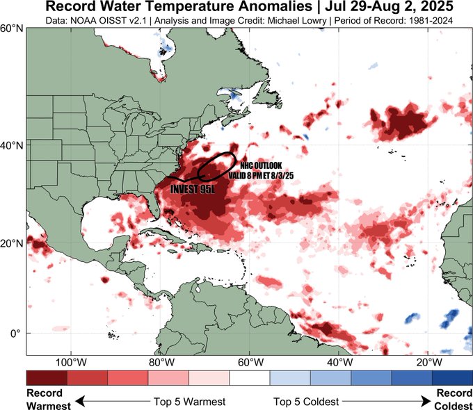
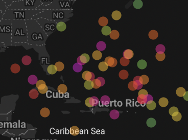
2025 Atlantic Hurricane Season
BarryStantonGBP replied to BarryStantonGBP's topic in Tropical Headquarters
Latest Deepminds (5th August, 6am) Dexter: "Erin": "Fernand" (Dexter copycat): "Gabrielle": "Humberto":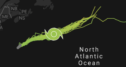


-
79/65. Still have sun despite the smoke
-
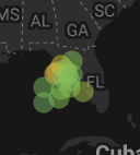
SE Area of Interest--10% two day, 40% five day odds
BarryStantonGBP replied to WxWatcher007's topic in Tropical Headquarters
Google DeepMinds has systems all the way from Erin to fucking Humberto -
I actually enjoy the extended summer these days--it's still a relatively short season around here
-
Do a trip to 5 Islands Lobster in Georgetown and combine it with a visit to the beach at Reid state park which is only 2 or 3 miles down the road on the same peninsula. Frosty's in Brunswick is only open 4 days a week but makes great donuts. https://apps.web.maine.gov/cgi-bin/online/doc/parksearch/details.pl?park_id=13 https://fiveislandslobster.com/ https://www.frostysdonuts.com/
-
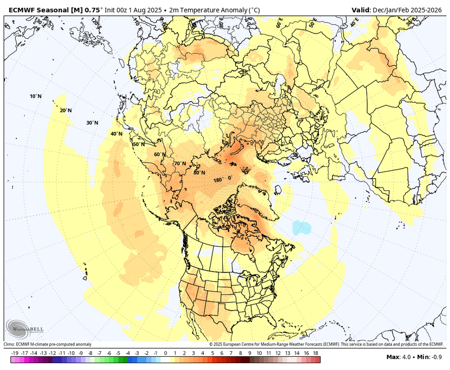
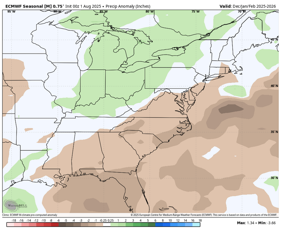
 The Euro seasonal is going with a delayed start to fall which has become common in recent years.
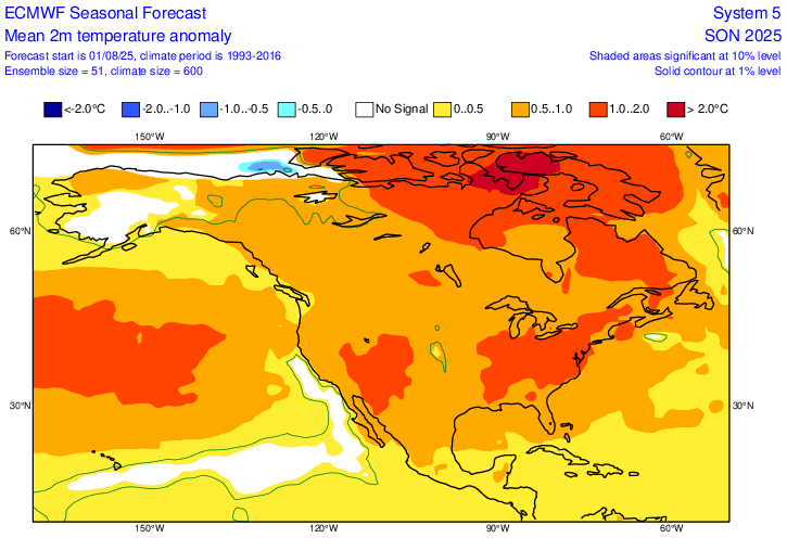
- Today
-
2025-2026 ENSO
40/70 Benchmark replied to 40/70 Benchmark's topic in Weather Forecasting and Discussion
I would think it would be tough to get too many major lows plowing through the lakes with a vortex INVO of Hudson's Bay....these charts scream SWFE/Miller B to me. Also trying to think of what would bias the models towards higher heights over AK in a cool ENSO. They would have to be underestimating La Nina and/or developing it too far east. I am confident this isn't going to be a robust Nina, so I buy the -EPO, which aligns with all of my early seasonal work. Now, maybe they are underdoing CC and it will be generally somewhat warmer...okay. Maybe they are also underplaying the +WPO influence given how stout that West warm pool is, but it may be tough to get the +WPO to exotic levels with stout EPO blocking. Interesting- -
 were you able to see any sunspots? zero sun here today
 -
1999: Governors of four Mid-Atlantic States imposed mandatory water restrictions as the worst drought in the history of the region continued. The period April through July ranked as the second driest ever for the Northeast, second only to 1965. (Ref. Wilson Wx. History) One of my favorite summers of all time !!! Highs: EWR: 102 (1944) NYC: 101 (1944) LGA: 100 (1955) JFK: 96 (2010) a list of record highs from some of our BEST summers!!!
-
We won't have a full day of sunshine again until Friday. When I saw the forecasts on Sunday I knew that Monday would be our last good day until Friday. I also knew that Monday would be our warmest day and Tuesday would be nowhere close to that. Fortunately, the sunny weather is timed well for the weekend. Forget about the clouds, the smoke is MUCH worse. I had some breathing issues this morning and a headache when I woke up and I knew exactly where it came from-- the smoke causing the air pollution.
-
The White Mountains area really isn’t all that far away. Head up towards Fryeburg then west from there to Conway. At that point you are fairly close to the Kanc, which has some great swimming spots along side it.