All Activity
- Past hour
-
The humidity is really going to be a monster to overcome this week. Today was the "cooler" day of the heat wave and it was downright NASTY out this afternoon. 94/75 for the hi/low in my neighborhood. The dew point was able to breach 80 today in the middle of the afternoon with a majority of the time hovering around 77-79. Brutal
-
Stifling out. 87 dew 74.
-
Anybody just hear that? wasn’t lightning
-
Hope we see some triple digits at key sites. This will be high-end heat and humidity for another couple days regardless of if it hits 100F or not. 95-99F with high dews is uncomfortable enough.
-
10PM EWR: 87 LGA: 87 NYC: 85 JFK: 85 New Brnswck: 82
-
Yep, I only wear shorts working when it's an absolute necessity.
-
 weatherjp joined the community
 -
He's fine. Nature has a way of adapting.

-
So dumb
-
Not sure why anyone thinks rain on Sunday impacts our highs in Tuesday. A theory floated by some experienced posters as well. Bizarre
-
Yeah , it looks so cold at the end of the week you almost wonder if it's worth it?
-
Someone should go check on Wolfie..
.thumb.png.9ce209dd76f4d95c6557ac072f8eef41.png)
-
 For reference for tomorrow:
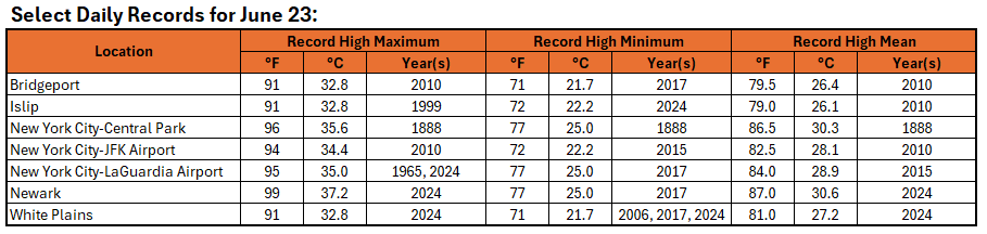
-
Todays highs.
-
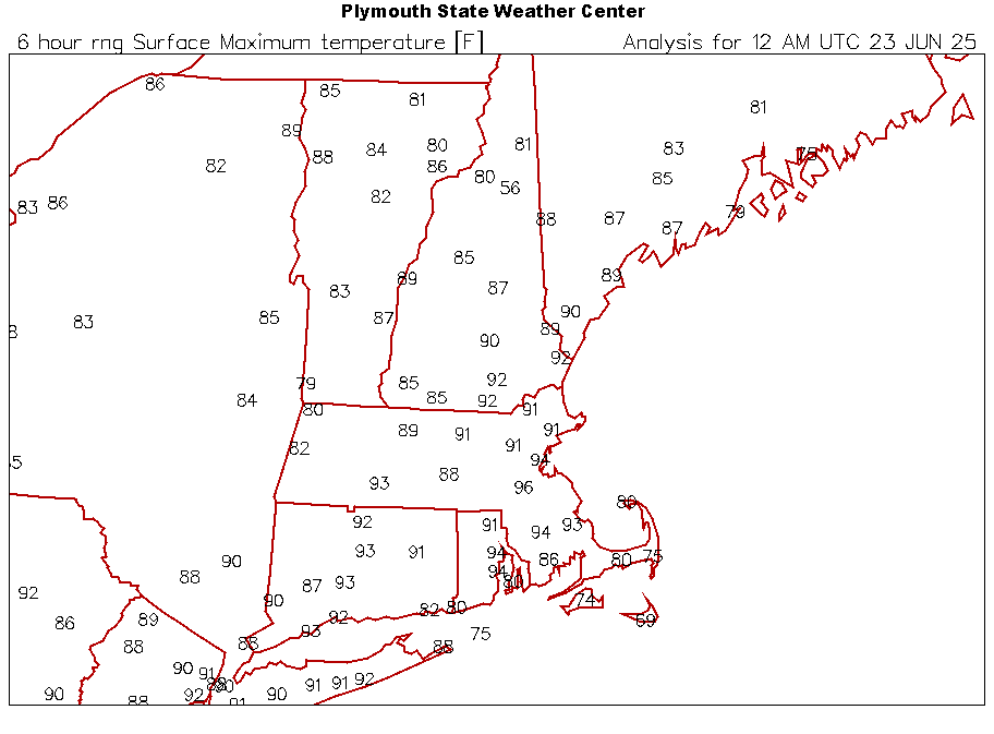
 9pm CP 85. Heat index 91 EWR 88. Heat index 95
 -
9pm CP 85. Heat index 91 EWR 88. Heat index 95
-
I’m getting 1995 nostalgia with the breezy solstice sunsets and 100° days. Edit…of course last year was similar at the solstice too.
-
9:30 p.m. and holding at 80 degrees here. Very muggy evening with no breeze at all.
-
Similar ridge position and forecasted 850 MB temps (100s) Park of course missed , especially having come out of a very wet June 2013 7/18: EWR: 101 LGA: 100 JFK: 100 NYC: 98 7/19: EWR: 100 LGA: 100 NYC: 96 JFK: 95
-
9:30 p.m. and holding at 80 degrees here. Very muggy evening with no breeze at all.
-
Winds were more northerly than expected. For this reason islip and westhampton were in the low 90s and the north shore cooler. Wasn’t hot at all in Lloyd Harbor today.
-
Forecast low of 68 but I am already down to 75 off my high of 87.4
-
67 in Montauk and 107 in the city. k
-
5 degree bust for me in the point & click. 93 and only got to 88.
- Today
-
Calm down, you’re like 4 degrees warmer than here . BTV is warmer than you at 81F currently. We are in it with ya. It’s a classic summer evening.


.png.56852ed3179ff5b0785423b44d81e6b1.png)


