All Activity
- Past hour
-

2025-2026 ENSO
Stormchaserchuck1 replied to 40/70 Benchmark's topic in Weather Forecasting and Discussion
True, that is some very impressive heat out there now. -

2025-2026 ENSO
TheClimateChanger replied to 40/70 Benchmark's topic in Weather Forecasting and Discussion
True, but a very impressive heat wave is ongoing now. Phoenix has set two record highs already this month, including 116F yesterday, which was just 1F shy of the all-time monthly record. The low of 94F this morning was also one shy of the monthly record high minimum. Today is forecast to reach 117F which would match the August monthly record high. -
Had a noisy owl across the street last night, freaked out my puppy.
-

2025 Atlantic Hurricane Season
WxWatcher007 replied to BarryStantonGBP's topic in Tropical Headquarters
As you know, it used to be the case that we didn’t start threads unless there was an invest or area of interest near a coastline… -
2025-2026 ENSO
TheClimateChanger replied to 40/70 Benchmark's topic in Weather Forecasting and Discussion
Interesting. Wonder if there is any chance for a late Beaufort melt to gain some ground? Delayed, but not denied, as JB would say. -
2025-2026 ENSO
Stormchaserchuck1 replied to 40/70 Benchmark's topic in Weather Forecasting and Discussion
Also a strong Gulf of Alaska High pressure has been there June-July Analogs US Temp pattern of analogs -
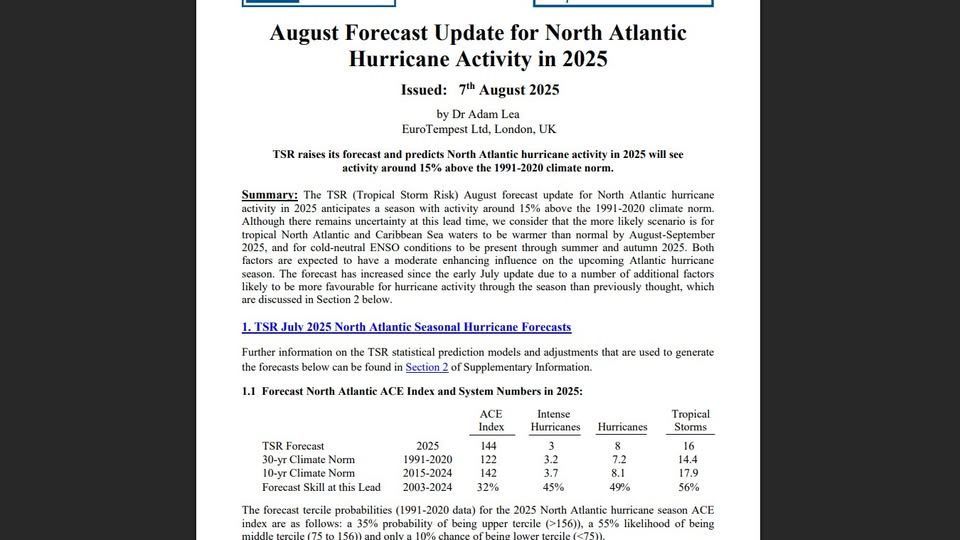
Since Atlantic ACE is considered to be a winter forecast factor: TSR just updated their forecast from last month…. -ACE increased markedly from 126 to 144. This compares to the CSU’s 145 and the Euro seasonal’s ~155. -The # of NS/H/MH increased slightly from 15/7/3 to 16/8/3. -However, US impacts remained the same at 4 NS/2 H. https://www.tropicalstormrisk.com/docs/TSRATLForecastAugust2025.pdf
-
SE Area of Interest--10% two day, 30% five day odds
WxWatcher007 replied to WxWatcher007's topic in Tropical Headquarters
It being unable to sustain meaningful convection last night definitely hurt chances imo but I still think it has a chance once it turns NE. -
TSR just updated their forecast from last month: -ACE increased markedly from 126 to 144. This compares to the CSU’s 145 and the Euro seasonal’s ~155. -The # of NS/H/MH increased slightly from 15/7/3 to 16/8/3. -However, US impacts remained the same at 4 NS/2 H. https://www.tropicalstormrisk.com/docs/TSRATLForecastAugust2025.pdf
-
Probably will be for life
-
2025-2026 ENSO
Stormchaserchuck1 replied to 40/70 Benchmark's topic in Weather Forecasting and Discussion
This Summer has been significantly cooler in the Southwest, US. Last year Phoenix was breaking records by >+2F, and the roll forward of those very warm analogs had a +PNA in Dec-Jan.. It was a good indicator. But we don't have that this year. -

2025-2026 ENSO
40/70 Benchmark replied to 40/70 Benchmark's topic in Weather Forecasting and Discussion
I just hope to god its wetter for the NE or I'll plunge into the Japanese piss-pool. -
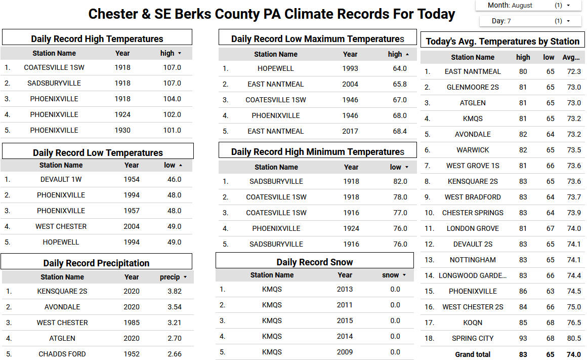
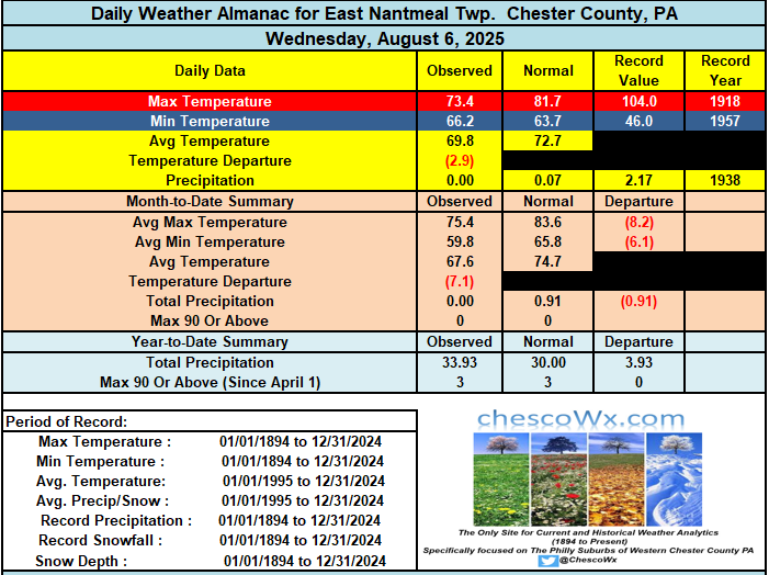
A great stretch of weather ahead with slowly warming temperatures. After a weekend with below normal temperatures with overnight lows in the 50’s and highs not too far from 80 degrees we should see temps getting well into the 80's by the start of the new work week. There could even be some 90's especially as usual across the valley locations by the middle of the week. No rain chances till at least Wednesday.
-

E PA/NJ/DE Summer 2025 Obs/Discussion
ChescoWx replied to Hurricane Agnes's topic in Philadelphia Region
A great stretch of weather ahead with slowly warming temperatures. After a weekend with below normal temperatures with overnight lows in the 50’s and highs not too far from 80 degrees we should see temps getting well into the 80's by the start of the new work week. There could even be some 90's especially as usual across the valley locations by the middle of the week. No rain chances till at least Wednesday.
-
It’s a bigger problem … it’s a socio-technological related forcing in group response. There is too much varied information, exceeding processing/categorization capacity of most of population. It’s entirely intuitive that this will integrate unfavorably in groups and larger orders … setting off the cultural mode of distrust of information - compounding this dilemma … there are nefarious manipulators clever enough to even leverage that confusion because they benefit from uncertainty and the anxiety an uncertain world instills at a personal level. This is why nationalism-type modes have popularized in recent decades, world over. It’s really all a defensive contraction born out of fear of lost identity(s). The sense of invading ethos breeds pathos. Tribalism in some respects is also apropos as a response description. So it’s really more than media. It’s how tech has interfered with the social evolution of humanity. Some can handle it. Many can not. There are legit information sources … the few that engage in the Machiavellian distortion shit are living in a hay-day, for their nefarious goals thrive in a basis of obfuscating information saturation.
-
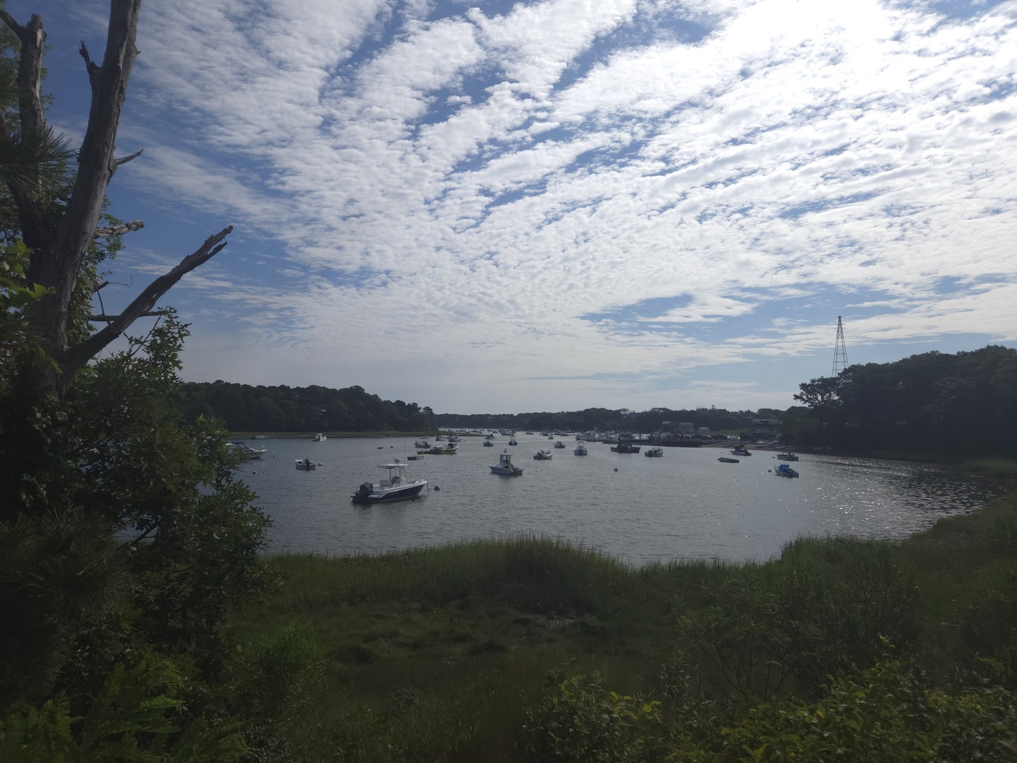
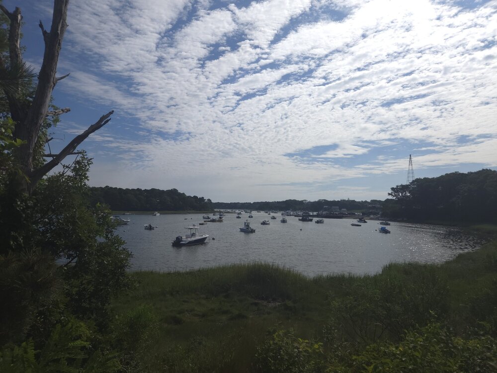
we Chatham. Orleans next
-
Shame nice weather always comes with smoky a sky. I agree though. Beautiful.
-
2025-2026 ENSO
Stormchaserchuck1 replied to 40/70 Benchmark's topic in Weather Forecasting and Discussion
24-25 is probably my top analog for 25-26 right now. Since 2014 though, there have been only like 3-4 periods where we had sustained below average for a 2+ month period, like last Winter. So the odds are stacked against it. It's not impossible though. -
Squirrels have been feasting on something in the woods behind our pool. I am surprised we have any based on the hawk and owl populations here
-
We only planned on using it for the summer. It was in phenomenal shape, it was only used once. The person who purchased it before last summer passed away and whoever was going through the stuff listed it on Facebook marketplace and for free. Came with 2 pumps and 2 sets of hoses, filters, pH strips, everything. Pretty good fine for one summer!
-

SE Area of Interest--10% two day, 30% five day odds
BarryStantonGBP replied to WxWatcher007's topic in Tropical Headquarters
1. Off the Southeastern United States: A weak area of low pressure located a couple of hundred miles off the coast of the southeastern United States is producing minimal shower and thunderstorm activity. Some slow tropical or subtropical development is possible over the weekend while the system moves northward to northeastward, remaining well off the east coast of the United States. By early next week, the low is expected to become extratropical, ending its chances for tropical development. * Formation chance through 48 hours...low...near 0 percent. * Formation chance through 7 days...low...30 percent. -
WELCOME ABOARD INVEST 96L (10/60)
BarryStantonGBP replied to BarryStantonGBP's topic in Tropical Headquarters
2. Central Tropical Atlantic (AL96): A tropical wave over the central tropical Atlantic is producing disorganized shower activity. Environmental conditions are forecast to become more conducive for gradual development in a few days, and a tropical depression could form late this weekend or early next week while the system moves west-northwestward to northwestward across the central tropical and subtropical Atlantic. * Formation chance through 48 hours...low...10 percent. * Formation chance through 7 days...medium...60 percent. -
If that has been used, I would stay away from it. They don’t last long.
-
Yeah much clearer here today.
-
Much clearer here than the last few days. Actually looked blue-ish