All Activity
- Past hour
-

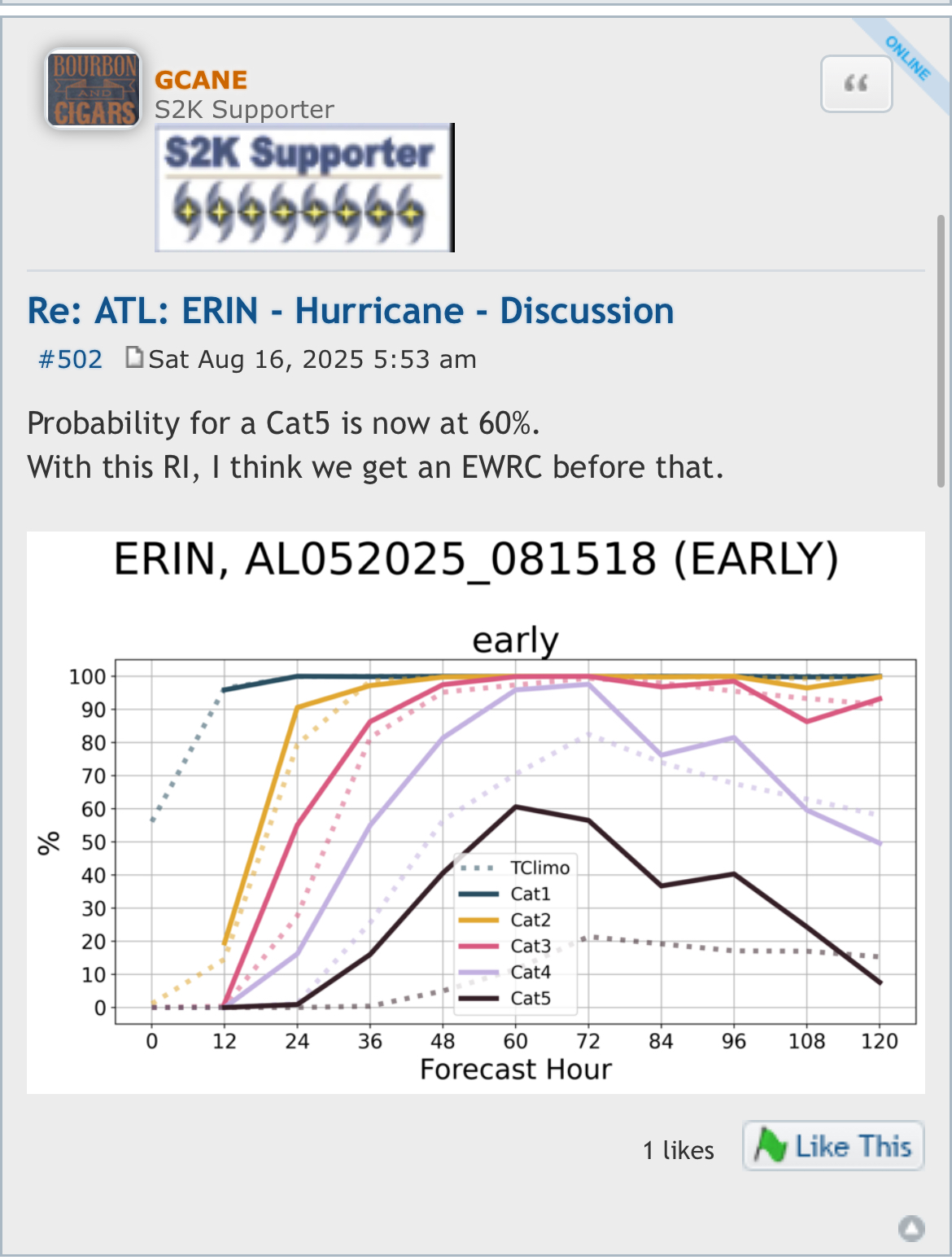
Hurricane Erin - 145 mph - 935mb - WNW @ 20
Eskimo Joe replied to BarryStantonGBP's topic in Tropical Headquarters
Uh, is Erin now outside the cone? -
Man MoreGarbage is cringe worthy.
-
Looks like we warm right back up last week of the month.
-
Got down to 56° in Falmouth. Chilly with the fans going. Water restrictions are already in place here.
-

Hurricane Erin - 145 mph - 935mb - WNW @ 20
WxWatcher007 replied to BarryStantonGBP's topic in Tropical Headquarters
931.9mb extrapolated on the latest pass with a 143kt FL wind. -
>Probably looking high temps upper 70s to low 80s with reasonable dewpoints if this verifies. It had better. To hell with this humidity. To hell with every damn summer being longer and muggier than the last. I want things to go back to normal, and by normal I mean the mild summers of the early sixties.
-

Hurricane Erin - 145 mph - 935mb - WNW @ 20
NorthHillsWx replied to BarryStantonGBP's topic in Tropical Headquarters
Pretty good example of the potential in the SW Atlantic this season. -
Pretty impressive. Looks like 155 mph from recon. Still seems to be intensifying quickly. Some big pressure drops between passes. Sent from my SM-S901U using Tapatalk
-
Hurricane Erin - 145 mph - 935mb - WNW @ 20
Eskimo Joe replied to BarryStantonGBP's topic in Tropical Headquarters
Wow good morning Erin. -

Hurricane Erin - 145 mph - 935mb - WNW @ 20
hawkeye_wx replied to BarryStantonGBP's topic in Tropical Headquarters
6 mb drop in the last 50 minutes. -

Central PA Summer 2025
Mount Joy Snowman replied to Voyager's topic in Upstate New York/Pennsylvania
Low of only 73. Looks like some relief is on the way for the start of the work week. -

Hurricane Erin - 145 mph - 935mb - WNW @ 20
weatherCCB replied to BarryStantonGBP's topic in Tropical Headquarters
145mph 135mb -

Hurricane Erin - 145 mph - 935mb - WNW @ 20
olafminesaw replied to BarryStantonGBP's topic in Tropical Headquarters
Unsurprisingly, a double wind maxima showing up now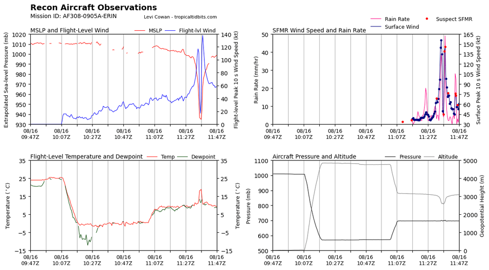
-
Hurricane Erin - 145 mph - 935mb - WNW @ 20
WxWatcher007 replied to BarryStantonGBP's topic in Tropical Headquarters
On cue 8:00 AM AST Sat Aug 16 Location: 19.6°N 62.0°W Moving: WNW at 20 mph Min pressure: 935 mb Max sustained: 145 mph -
Hurricane Erin - 145 mph - 935mb - WNW @ 20
WxWatcher007 replied to BarryStantonGBP's topic in Tropical Headquarters
Latest dropsonde found a 936mb pressure w/ 14kt wind. The last VDM was at 942mb. Expect a more powerful storm at the 8am advisory… -
Where’s @ineedsnow?
-
Hurricane Erin - 145 mph - 935mb - WNW @ 20
WxWatcher007 replied to BarryStantonGBP's topic in Tropical Headquarters
Pressure dropping like a rock with some big FL and SFMR winds at the center. -
Rapid intensification of yore Go to bed with a 1, wake up to a 4.
-
Hurricane Erin - 145 mph - 935mb - WNW @ 20
NorthHillsWx replied to BarryStantonGBP's topic in Tropical Headquarters
She’s a beaut, Clark -
If it can avoid an ERC. Exceptional pressure falls
-

Hurricane Erin - 145 mph - 935mb - WNW @ 20
Wannabehippie replied to BarryStantonGBP's topic in Tropical Headquarters
5:50 AM AST Sat Aug 16 Location: 19.6°N 61.5°W Moving: WNW at 20 mph Min pressure: 948 mb Max sustained: 130 mph - Today
-
Erin's a regular smoke show this morning. Impressive intensification overnight.
-
Hurricane Erin - 145 mph - 935mb - WNW @ 20
olafminesaw replied to BarryStantonGBP's topic in Tropical Headquarters
Not uncommon for strong hurricanes to continue trucking along more to the South than expected. Once it feels the weakness in the ridge, it will sharply turn right, probably not much West of forecast -

Hurricane Erin - 145 mph - 935mb - WNW @ 20
BarryStantonGBP replied to BarryStantonGBP's topic in Tropical Headquarters
-
Hurricane Erin - 145 mph - 935mb - WNW @ 20
BarryStantonGBP replied to BarryStantonGBP's topic in Tropical Headquarters
OI LASS WE COULD DO WITH SOME MORE INNIT


.thumb.png.4150b06c63a21f61052e47a612bf1818.png)