All Activity
- Past hour
-

November 2025 general discussions and probable topic derailings ...
toller65 replied to Typhoon Tip's topic in New England
My son is in Valdez, beautiful place Sent from my motorola edge 5G UW (2021) using Tapatalk -
I'm looking for recommendations for in-helmet sound/communication - anyone have anything they use and like? My son has simply been using Airpods as he listens to music while riding. I looked into the Cardo Packtalk units and Alec Nunchucks and liked the idea of on-mountain communication while actively riding. Reviews are kind of all over the place though with respect to group communication. Any recommendations for a quality/reliable setup you have experience with is appreciated. TIA
-

2025-2026 ENSO
40/70 Benchmark replied to 40/70 Benchmark's topic in Weather Forecasting and Discussion
Absolutely buy....that is the Pacific trough regime I expect to take hold around Xmas and through the first half of January that should flip to +TNH mid month. -
Can't I have a piece of that negative NAO? La Nina doesn't need that
-
That's the dream ain't it?
-

November 2025 general discussions and probable topic derailings ...
MJO812 replied to Typhoon Tip's topic in New England
Models keep overestimating the ridge in the long range just to lessen it when the time gets closer. We are in a weak la Nina. The south east ridge shouldn't be strong. -
Models keep overestimating the ridge in the long range just to lessen it when the time gets closer. We are in a weak la Nina. The southeast ridge shouldn't be strong.
-
-
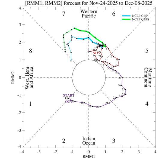
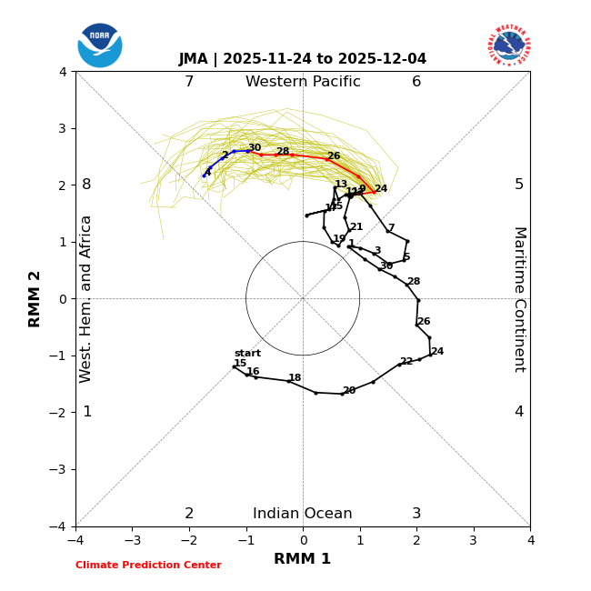
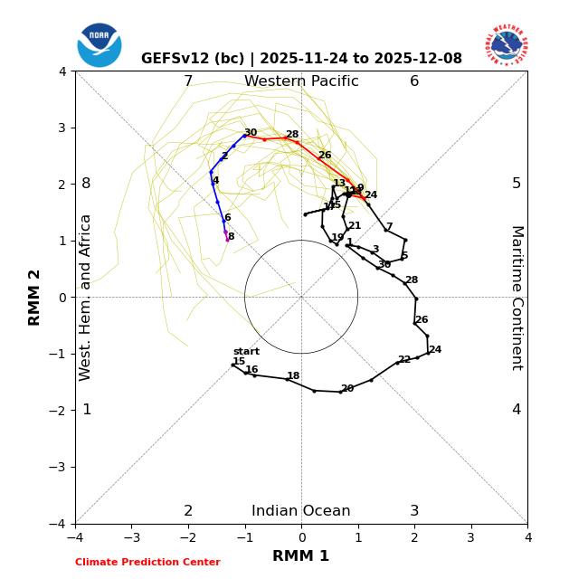
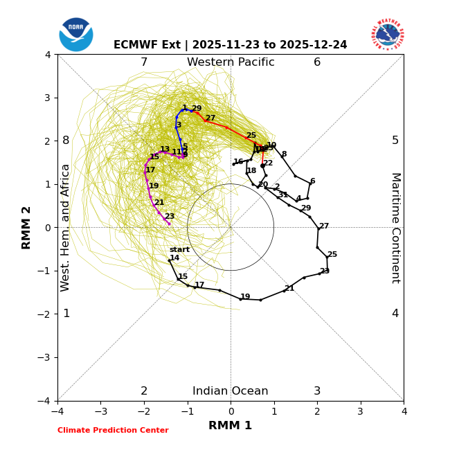
JMA looks like it is going to be the earliest to phase 8
-

December 2025 Short/Medium Range Forecast Thread
Carvers Gap replied to John1122's topic in Tennessee Valley
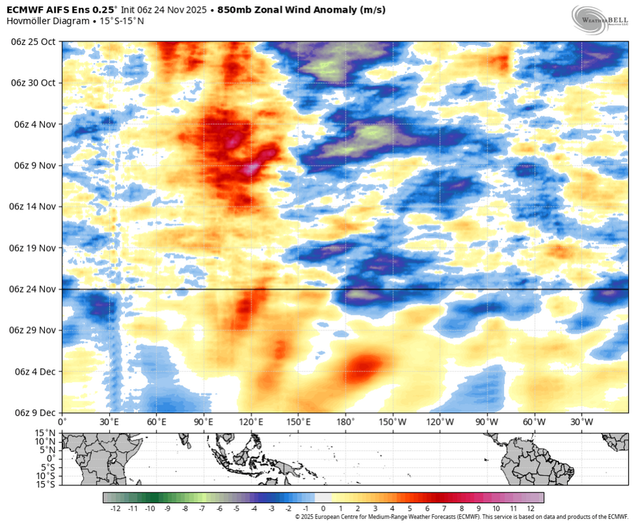
If I am cherry picking models...I sure like the 6z AIFS paired w/ the 6z GFS. -
Normal GEFS has it in phase 8 by DEC 6th now:
-

2025-2026 ENSO
brooklynwx99 replied to 40/70 Benchmark's topic in Weather Forecasting and Discussion
I would argue that the models are underdoing the Pacific jet and + heights near the WC and AK given that kind of tropical forcing unless the MJO can never get into 8, which I'm sure I'll be told -
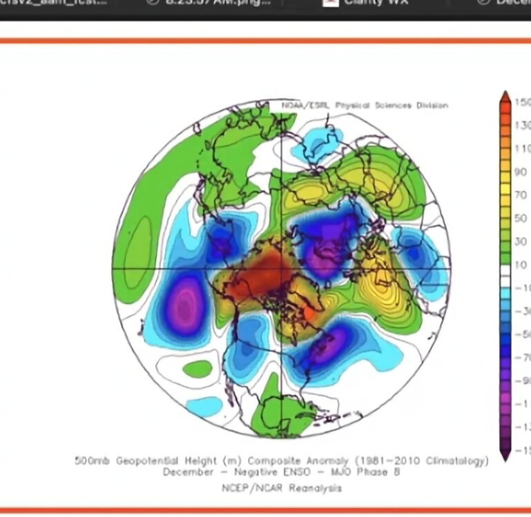
yeah strong nino decembers can “bust cold” such as with 2009 blocking, while nina decembers can “bust warm” such as with 2021. with the new climate, the odds of course are always more favorable to go warm than cold. i don’t think this december ends up torching though, especially northern tier. i can see it going 1-2 above.
-
@stormtracker,practice starts next Monday
-

Central PA Fall Discussions and Obs
canderson replied to ChescoWx's topic in Upstate New York/Pennsylvania
My smoked turkey from Texas arrived this am. Good eating ahead. Happy Thanksgiving, all. Big winds seem likely later this week and then maybe some snow soon. -

2025-2026 ENSO
Stormchaserchuck1 replied to 40/70 Benchmark's topic in Weather Forecasting and Discussion
I mean if that MJO forecast verifies, it will be a weird Pacific H5 for what the MJO is. Something to watch to see if that happens: MJO amped in 7-8 and a -PNA/+AO pattern -

2025-2026 ENSO
PhiEaglesfan712 replied to 40/70 Benchmark's topic in Weather Forecasting and Discussion
2020-21 is the only winter in NYC that even surpassed the 20-inch mark since 2018-19: 2019-2020 0.0 0.0 0.0 0.0 0.0 2.5 2.3 T T T T 0.0 4.8 2020-2021 0.0 0.0 0.0 0.0 0.0 10.5 2.1 26.0 T 0.0 0.0 0.0 38.6 2021-2022 0.0 0.0 0.0 0.0 T 0.2 15.3 2.0 0.4 0.0 0.0 0.0 17.9 2022-2023 0.0 0.0 0.0 0.0 0.0 T T 2.2 0.1 0.0 0.0 0.0 2.3 2023-2024 0.0 0.0 0.0 0.0 T T 2.3 5.2 T 0.0 0.0 0.0 7.5 2024-2025 0.0 0.0 0.0 0.0 0.0 2.8 3.0 7.1 0.0 0.0 0.0 0.0 12.9 -
2025-2026 ENSO
Stormchaserchuck1 replied to 40/70 Benchmark's topic in Weather Forecasting and Discussion
CFS runs 4x a day, and sometimes it will have the whole US below at 12z then the whole US above at 18z. Running more helps tracking scores to improve for more data.. but 2-4 week models haven't proven much more accurate than seasonal models to this point. I personally like the 384hr map on the ensemble means, seeing what the NAO, PNA, AO patterns look like.. that is pretty accurate. There is a pretty big model drop off after Day 15. Maybe they will continue to upgrade the Euro ensembles, but they have had some big misses since coming into inception several years ago. -
Weeklies should be run every week again instead of daily.
-
A better pattern still looks on track in December . MJO going into 8. Delayed but not denied ?
-
2025-2026 ENSO
Stormchaserchuck1 replied to 40/70 Benchmark's topic in Weather Forecasting and Discussion
Remember how bad they were in 23-24? The 2-4 week period still has lot of work to do for more predictable models. There was a time in August when the weeklies had +5 around the Great Lakes and Upper Midwest for a 2-week period, and it ended up being like -5. Also, for all talk Strong Nino's get about having warm December's, you rarely hear about La Nina's and cold December's, but they do go hand-in-hand. But like I said a few days ago, when the -EPO ridge retrogrades and models want to significantly cool Alaska and NW Canada thereafter, that is a warmer pattern coming. -
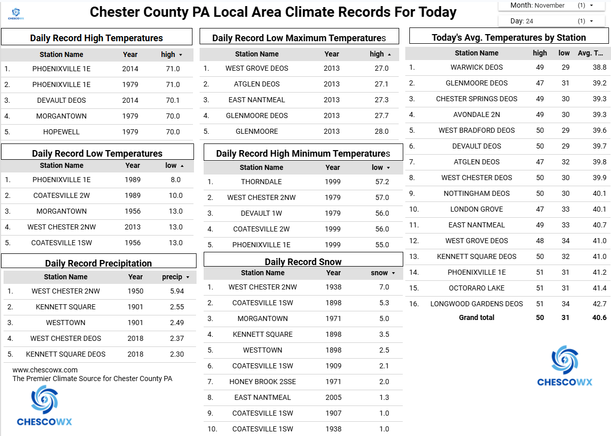
(002).thumb.png.6e3d9d46bca5fe41aab7a74871dd8af8.png)
Central PA Fall Discussions and Obs
ChescoWx replied to ChescoWx's topic in Upstate New York/Pennsylvania
The sun finally is out there today! Enjoy as we may not see it too much after today until Turkey Day. Rain arrives tomorrow afternoon and looks to continue for at least part of the day on Wednesday. We turn sunny and cold for Thanksgiving weekend with highs from Thursday through Saturday struggling to escape the 30's to near 40 degrees in most spots.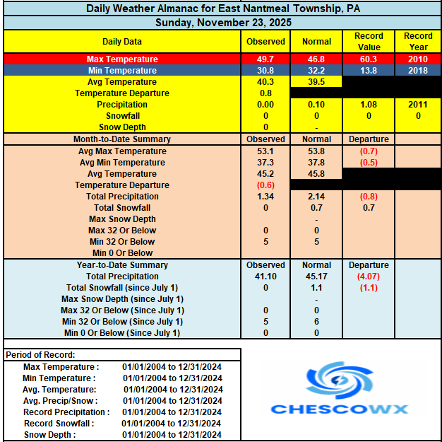

-
E PA/NJ/DE Autumn 2025 Obs/Discussion
ChescoWx replied to PhiEaglesfan712's topic in Philadelphia Region
The sun finally is out there today! Enjoy as we may not see it too much after today until Turkey Day. Rain arrives tomorrow afternoon and looks to continue for at least part of the day on Wednesday. We turn sunny and cold for Thanksgiving weekend with highs from Thursday through Saturday struggling to escape the 30's to near 40 degrees in most spots.
-
Yeah we've seen a big breakdown in what was going to be favorable for cold and snow. December is now looking quite mild for our area. Seems like the positive AO will link up with SER and keep us warmer than normal in December. That won't work for snowfall chances. Our best hope is that the cold and snow builds up to our west and north and cold can bleed down towards our area. But like I said yesterday, things don't look too active for much of CONUS for forseeable future.
-

Pittsburgh PA Fall 2025 Thread
TheClimateChanger replied to TheClimateChanger's topic in Upstate New York/Pennsylvania
Even better elsewhere, back when there were more official snowfall observations. Morgantown came in with nearly a foot. Northern Pennsylvania got clobbered. The daily reported snowfall on the 11th appears to have been so high at DuBois, it got automatically rejected by the automated rejection feature for suspect readings in xMacis. A review of the daily snowfalls and change in depth suggests over 2 feet fell, with depths peaking at 34" from the 12th through 14th. Bradford had a peak depth of 39 inches.