All Activity
- Past hour
-

New Years Day 2026 - 1st snows of the new year possible
Ginx snewx replied to Baroclinic Zone's topic in New England
2nd line crushed here still moderate with another inch down -

New Years Day 2026 - 1st snows of the new year possible
Bryan63 replied to Baroclinic Zone's topic in New England
Think we'll have a good shot with that second line though. -

New Years Day 2026 - 1st snows of the new year possible
Fozz replied to Baroclinic Zone's topic in New England
If round 2 lasts long enough then I think you’ll get the brunt of that. -
Winter of yore today.
-

New Years Day 2026 - 1st snows of the new year possible
ORH_wxman replied to Baroclinic Zone's topic in New England
Congrats Scooter…RI/MA border though is gonna get hit twice by the max intensity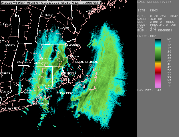
-

New Years Day 2026 - 1st snows of the new year possible
CoastalWx replied to Baroclinic Zone's topic in New England
Big flakes at home. No wind. -
26 / 4 sunny about 0.75 of fluffy snow with the arctic frontal passage. Happy New Year! Breezy and cold today through Monday. The shift in forecasting on the 30th sustained overnight with ridging into the east in the 1/6 - 1/10 period with moderation perhaps towards midmonth - colder.
-

New Years Day 2026 - 1st snows of the new year possible
Baroclinic Zone replied to Baroclinic Zone's topic in New England
Guess this panned out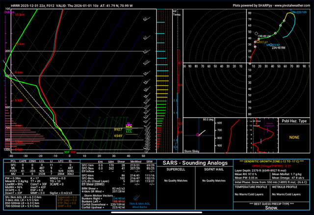
-
It’s the protect people and property thing. The warnings are not for you and me, they’re for the people who just get a glance on their phone. .
-

New Years Day 2026 - 1st snows of the new year possible
TauntonBlizzard2013 replied to Baroclinic Zone's topic in New England
Looks like the meat is going north of here -
New Years Day 2026 - 1st snows of the new year possible
ORH_wxman replied to Baroclinic Zone's topic in New England
Woonsocket might get like 2-3” from the squalls alone….man. -
Snow squall whiten up everything here. People outside shoveling .
-

New Years Day 2026 - 1st snows of the new year possible
Spanks45 replied to Baroclinic Zone's topic in New England
2.2" Southbury Suns out, 22⁰ -
New Years Day 2026 - 1st snows of the new year possible
Fozz replied to Baroclinic Zone's topic in New England
Another squall is strengthening as it reaches RI. Incredible. -

New Years Day 2026 - 1st snows of the new year possible
moneypitmike replied to Baroclinic Zone's topic in New England
LOL--I was just looking at the radar wondering where the echos were. Still coming down here.......guess it'll be short-lived. -

E PA/NJ/DE Winter 2025-26 Obs/Discussion
Ralph Wiggum replied to LVblizzard's topic in Philadelphia Region
Newest Hrrr now has a car topper for parts of SE PA tonight. -
New Years Day 2026 - 1st snows of the new year possible
Baroclinic Zone replied to Baroclinic Zone's topic in New England
And round 2 hot on its tail -
New Years Day 2026 - 1st snows of the new year possible
moneypitmike replied to Baroclinic Zone's topic in New England
Finally---some heavy wind-blown snow here in PVD. -
New Years Day 2026 - 1st snows of the new year possible
Baroclinic Zone replied to Baroclinic Zone's topic in New England
Vis 200yds -
.thumb.jpg.aec747d13df1d95d5fed34574f74d4fd.jpg)
New Years Day 2026 - 1st snows of the new year possible
Vinny Findley replied to Baroclinic Zone's topic in New England
CT doing well this year so far. Precip here just not hanging on. Squall lasted barely a minute. -

New Years Day 2026 - 1st snows of the new year possible
The 4 Seasons replied to Baroclinic Zone's topic in New England
Staffordville 4.3" -
New Years Day 2026 - 1st snows of the new year possible
Baroclinic Zone replied to Baroclinic Zone's topic in New England
Whiteout -
A Snow squall warning for NYC 10 mile radius? Really? You know people living near the Great Lakes are laughing right now? To me, some things are not relative. True whiteout does not mean visibility is reduced. It means there is no visibility (okay, maybe up to 10 car lengths). Just a pet peeve.
-
New Years Day 2026 - 1st snows of the new year possible
The 4 Seasons replied to Baroclinic Zone's topic in New England
3.5" East Lyme and Warren. Those are the highest reports so far. I'm working on stuff to put out soon, and a CT list -
New Years Day 2026 - 1st snows of the new year possible
Vinny Findley replied to Baroclinic Zone's topic in New England
LMAO. As I shit on the radar, I can barely see the house across the street. Wind picking up. Intensity already letting up as I type this.


