All Activity
- Past hour
-
wish it ripped into W LI instead of limping, but take!
-
-
Outside with shorts and short sleeved shirt…not too bad actually. The coolness isn’t bothering like I thought it would. But I do miss 95/73
-
what the heck is going on?
-
Yeah I Know. That part is better. But risk is trough too far east. Eventually it will work out right? lol.
-
Man what a massive shift west today. Models really blew this one as did NHC . CC to ACK now into TS conditions
-
Happy hour on 18z GFS lol
-
I’m not so sure the Euro has that right but we’ll see. It’s not the prettiest trough/ridge combo but it’s better than what we have today lol. I can definitely see that wave struggling to consolidate until it gets past 60W.
-
How many you had ? Still early too
-
Picked up 0.06 from a decaying cell. This mornings progressive outflow boundary screwed us here for this setup. Will finish August with <1.25".
-
I’d lean Stein here.
-
Will be another fish storm lol.
-

Hurricane Erin: 140 MPH - 937 mb - NW @ 10
wthrmn654 replied to BarryStantonGBP's topic in Tropical Headquarters
Gfs another noticeable shift west and north.... lol this reminds me of winter storms the past few years non stop shifts... -
That's a monster hit sucks it's 10 days out
-
Ya can we just lock that in now lol
-
Doesn’t mean much of anything for us: meh. But looks like you initialized the next storm lol.
-
Drunk
-
Cocgust!
-
 74 for high Coldest day since 69 on 6/27 8 day heatwave comes to a crashing end
 -
Congrats @dendrite
-
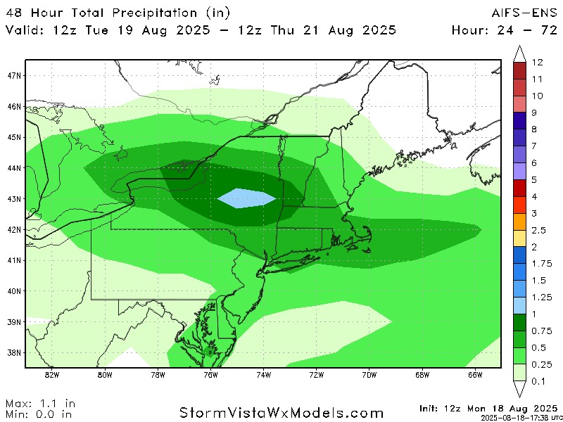
Mt Holly disco not buying into much significance of any rain
-
 They were taking everything off the beach in LBC
 -
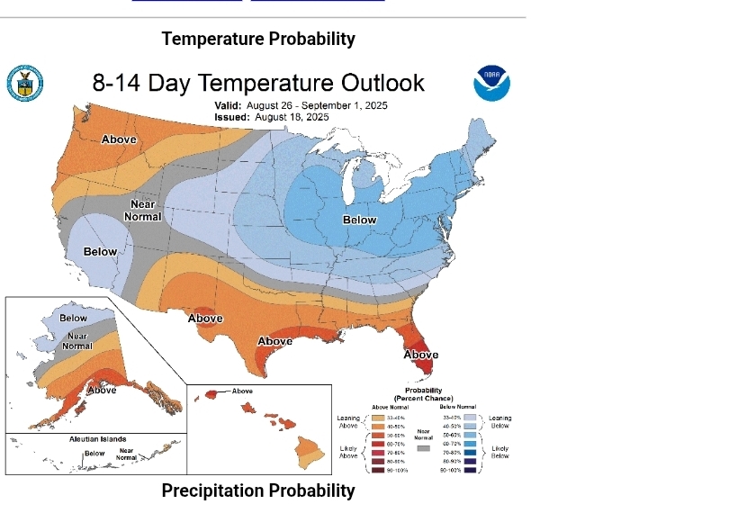
IMO, there is a high risk for a dry met fall (SON) again this year. I don’t think we see a record drought like last fall, but I can see us reach drought conditions none the less
-
End of the month looking nice too.
- Today
-
ALB to Dendy congrats on heavy rains Wednesday


