All Activity
- Past hour
-
According to Harrisburg Capital Airport, that's been open in the same location and collecting data since 1939, this summer was -.7F.
-
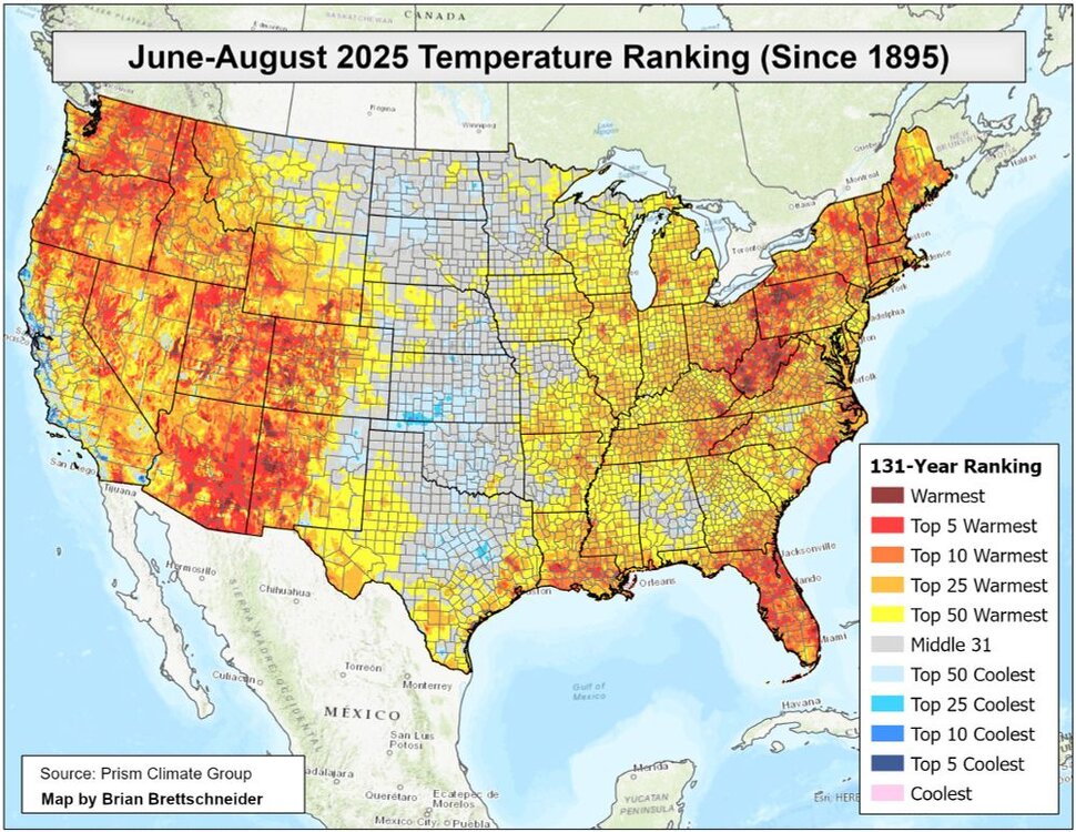
That map, though maybe close and maybe not, is not completely accurate per the map creator. https://prism.oregonstate.edu/historical/ They even state: Values prior to 1981 are based on less extensive observations.
-
Our feeders are filled too, fascinating birds, I love watching them.
-
Just to add to the August climate summary, MU came in BN for the month for temps and it was tied for the driest August on record.
-

September 2025 OBS-Discussion centered NYC subforum
bluewave replied to wdrag's topic in New York City Metro
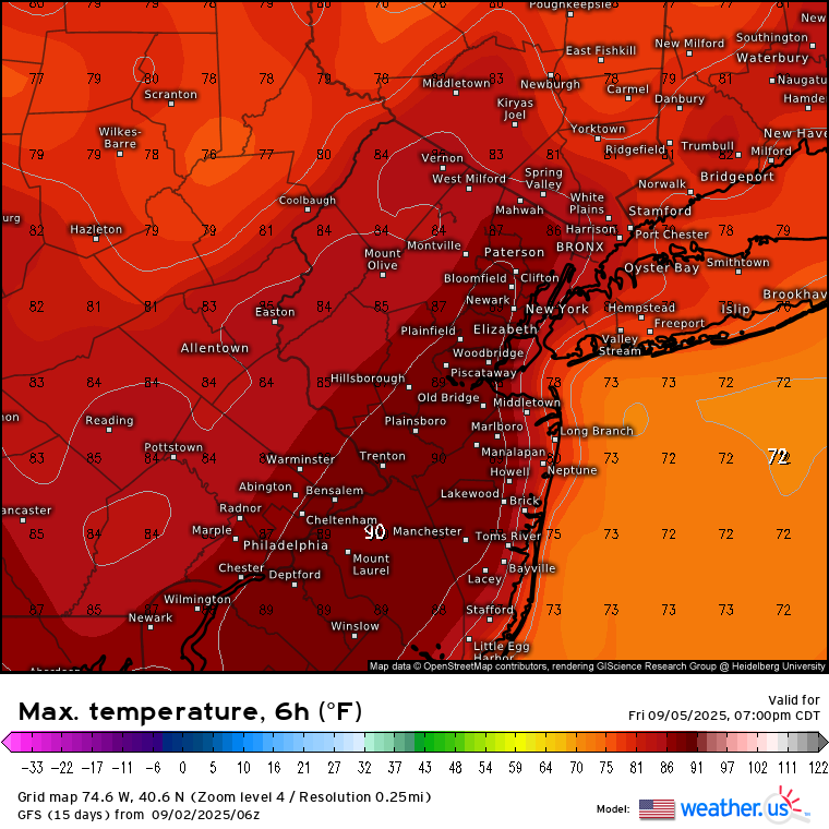
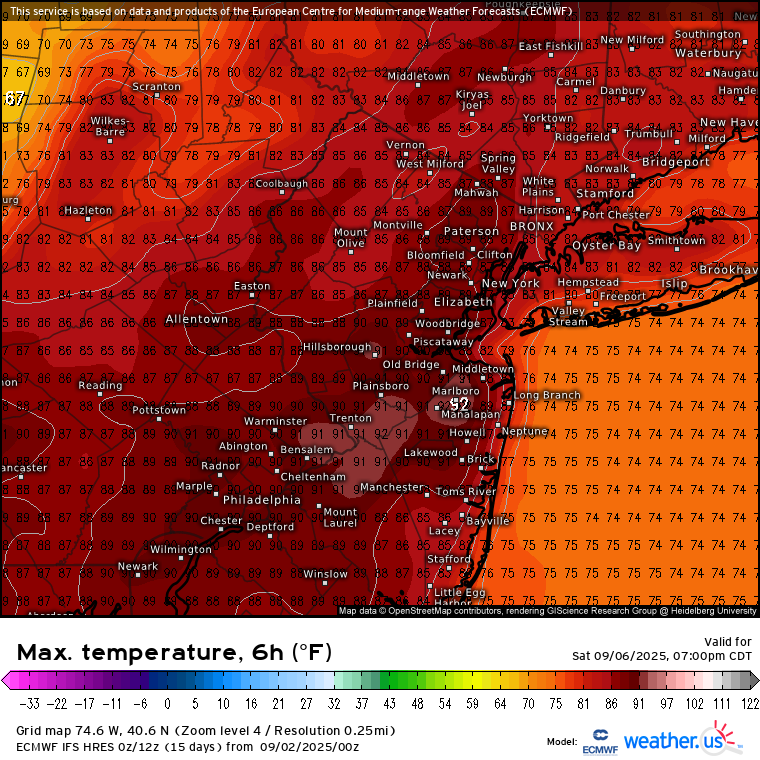
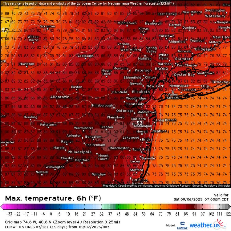
It will probably come down to frontal timing. The GFS has 90° on Friday for the warm spots in NJ. The Euro has a slightly slower frontal passage so the 90° on Saturday. Won’t take much to beat guidance by a few degrees with how dry it has been.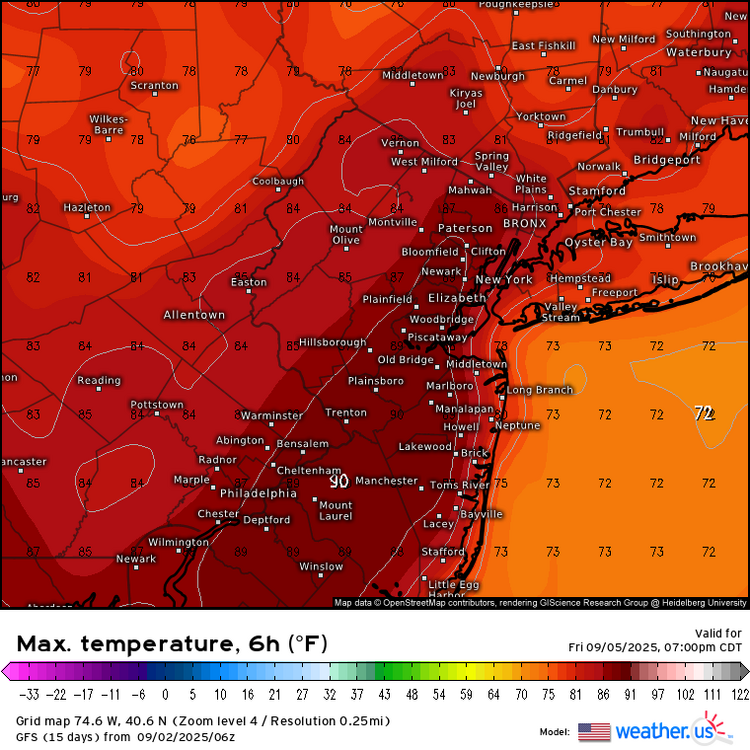
-
My 1.32" for August looks a lot better than your total, but the JJA total here was only 5.29", driest by nearly 2". (POR only 28 years) Curling leaves, bit of early color outside of the swamps, some leaf drop.
-
The August maps won’t update for several more days on that site. But the summer maps on some other sites that have updated are the same pattern. Warm in the East and West with cooler in the middle. The prism maps already updated for JJA with numerous top 10 warmest summer rankings for the Northeast.
-
Your summer 2025 was only for June and July. Adding August will make a noticeable difference methinks.
-

September 2025 OBS-Discussion centered NYC subforum
Stormlover74 replied to wdrag's topic in New York City Metro
Euro has a sneaky 90 for Saturday with a couple light rain chances late this week -

2025-2026 ENSO
40/70 Benchmark replied to 40/70 Benchmark's topic in Weather Forecasting and Discussion
I agree for the most part, but I still think we could pull off a sub 1981-2010 climo. I think it would be a low return type of anomaly, but I don't think that ship has sailed quite yet. I may be wrong- -
Friday looks Stein SNE.. especially S and E
-

September 2025 OBS-Discussion centered NYC subforum
SACRUS replied to wdrag's topic in New York City Metro
Highs: EWR: 105 (1953) NYC: 102 (1953) LGA: 102 (1953) JFK: 93 (1973) Lows: EWR: 49 (2017) NYC: 51 (1886) LGA: 56 (2017) JFK: 53 (1949) Historical: 1775: The Independence Hurricane This savage hurricane raged from North Carolina to Newfoundland. Heavy rains began to fall across the colony on the 29th of August and slowly increased with time. The coast was ravaged from Currituck to Chincoteague. Wharves and storehouses on the waterfront of Norfolk were devastated. Bridges were carried away by the raging waters. At Williamsburg, mill dams broke and corn stalks were blown flat. Winds blew furiously until 10:00 p.m. Many ships were damaged as they were thrown ashore at Norfolk, Hampton, and York. Around twenty-five vessels were run ashore, or "irrecoverable gone." The gun ship H.M.S. Mercury was driven hard aground on Portsmouth Point at 5:00 p.m. on the 2nd. It was stranded in two feet of water for eight days (Shomette). The Liberty became "hopelessly stranded" in Back River, near Hampton. A number of locals boarded her, captured the crew, secured her goods, and set the ship afire in the first outright act of war. A full blockade of Hampton Roads thereafter brought shipping to a halt for three months. At least twenty-five died due to shipwreck.(Ref. The Independence Hurricane) 1882: Possibly the first photograph of a lightning strike was taken on this day by William Jennings in Philadelphia, Pennsylvania. 1887: The U.S. Army Signal Service station in Greenville, SC reported a minimum temperature of 50°F. This observation at Greenville still stands as the record low for the day. Additional stations across the state recorded low temps in the low 50's. 1935 - Perhaps the most intense hurricane ever to hit the U.S. struck the Florida Keys with 200 mph winds. The hurricane produced a fifteen foot tide and waves thirty feet high. 400 persons perished in the storm on that Labor Day. The barometric pressure at Matecumbe Bay FL hits a record low for the U.S. of 26.35 inches. (David Ludlum) 1950 - The temperature at Mecca, CA, soared to 126 degrees to establish a U.S. record for the month of September. The low that morning was 89 degrees. (The Weather Channel) 1950: The temperature at Mecca, CA soared to 126 degrees to establish a U.S. record for the month of September. The low that morning was 89 degrees. (The Weather Channel) (Ref. WxDoctor) (Ref. AccWeather Weather History) 1953: Boston, Massachusetts had 100 °F for the second time ever in September. Chicago, IL hit 101° for the second day in a row and the tenth of 11 consecutive days with a high temperature at 90° or higher. (Ref. NOAA Boston Weather Events) 1961: Denver, CO picked up 4.2 inches of snow, the earliest measurable snow for the Mile High City. (Ref. AccWeather Weather History) 1982: A wind gust of 121 mph was reported at the Chautauqua County Airport near Jamestown, NY causing an estimated half million dollars in damages to the terminal building, planes, cars and landing instruments. Rainfall totals exceeded two inches in places. (Ref. Wilson Wx. History) 1985 1985 - After teasing residents along the Gulf of Mexico for two days, Hurricane Elena finally came ashore at Biloxi MS. The hurricane, packing winds of 127 mph, caused more than a billion dollars damage. (The Weather Channel) 1987 - Late evening thunderstorms in the Northern Plains Region produced wind gusts to 75 mph at Jordan MT, and a ""hot flash"" at Redig SD. The temperature at Redig rose from 66 degrees at 10 PM to 86 degrees at 11 PM as thunderstorm winds gusted to 36 mph. Nine cities in the Upper Ohio Valley, the Tennessee Valley and the Central Gulf Coast States reported record low temperatures for the date, including Elkins WV with a reading of 38 degrees. (The National Weather Summary) (Storm Data) 1988 - Unseasonably hot weather prevailed in the northwestern U.S. Afternoon highs of 98 degrees at Olympia WA, 98 degrees at Seattle WA, 105 degrees at Portland OR, and 110 degrees at Medford OR, established records for the month of September. Quillayute WA equalled their September record with an afternoon high of 97 degrees. (The National Weather Summary) 1989 - Eight cities in the Gulf Coast Region reported record high temperatures for the date as readings soared into the upper 90s. Houston TX and Port Arthur TX hit 99 degrees. Late evening thunderstorms, developing ahead of a cold front, produced wind gusts to 63 mph at Dickinson ND, and golf ball size hail in North Dakota and Nebraska. Winds along the cold front itself gusted to 62 mph at Buffalo SD. (The National Weather Summary) (Storm Data) 1996: After teasing the entire Atlantic coast with winds as high as 140 mph, Hurricane Edouard skirted New England without making landfall. Hurricane force winds were recorded on Nantucket and Cape Cod, but wind damage was relatively minor. 1996: Large swells from Hurricane Fran knocked five people out of an 18-foot fishing boat in Jupiter Inlet, FL. The Coast Guard rescued all five people. (Ref. Wilson Wx. History) 2002: An F3 tornado roared into downtown Ladysmith, WI at mid-afternoon, heavily damaging 64 blocks of the business district. Fortunately, it was Labor Day, and most of the stores were closed for the holiday or the toll would have been much worse. The National Weather Service came under fire for not issuing a tornado warning before the storm struck. (Ref. Wilson Wx. History) 2003: Indianapolis, IN was drenched with 7.20 inches of rain on this date for its greatest single day rainfall on record. (Ref. WxDoctor) 2006: Tropical Storm Ernesto dumped 8.93 inches of rain on Norfolk, VA for the city's greatest single day rainfall on record. (Ref. Wilson Wx. History) (Sep. 1st-2nd) Heavy rains from the remnants of Tropical Storm Ernesto fell on SE PA. In Schwenksville, a man jumped into an overflowing retention basin to try to rescue his dog. The dog was sucked into and through the outflow pipe and survived; his master drowned. (Ref. Weather Guide Calendar with Phenomenal Weather Events 2011 Accord Pub. 2010, USA) 2008: Northeastern Illinois: In Chicago the thermometer at O'Hare IAP hits 94°F (34.4°C), and Midway tops out at 95°F (35°C), the first such high there in 761 days, and the warmest day of the year Kankakee, New Lennox, Plainfield and Palatine (my home town hit 97°F. (Ref. WxDoctor) 2002: An F3 tornado destroyed much of the downtown area of Ladysmith, Wisconsin. Overall damage was estimated at $20 million, but there were no fatalities. -
Moving this over to the new month. Ditto here, seemed we went from low 70's to mid 50's in about an hour to 90 minutes after the sun set last evening! Currently 46.9/46.2 at 8 am after a 46.7 low.
-
https://theonion.com/hummingbird-feels-like-fucking-idiot-after-seeing-other-bird-gliding/
-
The main reason I use it is that my analysis and forecasts are based on the perspectives. So I need to compare it to what has happened in the period of record. But I understand that many seasonal forecasts are 1991-2020 departure based on where the areas of above and below temperatures are located. My guess from several years back that our next colder winter would only be colder relative to the much warmer 1991-2020 baseline worked out. As this past winter in the Northeast would have been slightly warmer based on earlier periods of record. DJF 2024-2025 Northeast 24.6° 1895-2000….+1.4° 1961-1990……+1.8° 1971-2000……+0.5° 1981-2010…….-0.3° 1991-2020……-1.2°
-
September 2025 OBS-Discussion centered NYC subforum
SACRUS replied to wdrag's topic in New York City Metro
60 / 59 partly cloudy another dry day upper 70s and low 80s. Warmer Wed - Fri SW flow with enough sun should get the warmest spots to mid / perhaps upper 80s with enough sun on Friday. Front comes through Friday night with some showers and storms bringing the chance of widespread rains since early August. A bit cooler but a nice dry weekend overall once passed Saturday morning. Warmer week overall above normal starting the 8th. - Today
-
2025-2026 ENSO
40/70 Benchmark replied to 40/70 Benchmark's topic in Weather Forecasting and Discussion
-
Almost looks similar to last year in some ways with lots of high pressure around. Hopefully enough moisture surges from the south to help deliver moisture.
-
2025-2026 ENSO
40/70 Benchmark replied to 40/70 Benchmark's topic in Weather Forecasting and Discussion
I don't think you are going to get pushback from anyone about how exceedingly difficult it is to get any season to finish below the longer term 1895-2000 climo...this is why I never use that climo base. It's not because I'm in denial about anything or trying to dissociate, but it's for the same reason that I don't begin every outlook by rehashing that the sky is blue. -
2025-2026 ENSO
40/70 Benchmark replied to 40/70 Benchmark's topic in Weather Forecasting and Discussion
Not too worried about that. Largest bias of climate models is to over-bake ENSO into the forecast, which should be weak. While I expect a +NAO, it's not going to be wall-to-wall IMO. -
I hope we can squeeze out some decent rain events this month. There’s a lot of dry patches starting to pop up in non-shaded areas. Perhaps the tropics can deliver a few goodies to us?
-
How were you relative to normal snowfall last year?
-
In a perfect world, yes, but the PDO is more of a longer term oscillation that doesn't always correlate to our sensible weather.
-
My guess would be location of thermometer to surface material grass vs. concrete (light colored hard surface) or asphalt (dark colored hard surface), sunlight, buildings, and river, or a combination of 2 or more, which results in warmer readings relative to other locations that have properly placed thermometers. "Properly placed" as in not effected by known microclimate features or natural microclimate features like direct sunlight or the Susquehanna river.
-
Looks like a mild and boring month coming up.