All Activity
- Past hour
-

Minor snow possible sunday 12/14/25
Franklin0529 replied to WeatherGeek2025's topic in New York City Metro
Lots of time left. Could become a strung out mess could pop an ocean storm and drop 3-6". Should know more definitively Tommorow night -
yeah - that one is gonna be a tough one to watch.
-

December 2025 regional war/obs/disco thread
TauntonBlizzard2013 replied to Torch Tiger's topic in New England
No, but if was a step back from 12z thougb -

December 2025 regional war/obs/disco thread
brooklynwx99 replied to Torch Tiger's topic in New England
the CMC isn’t that far off from the ECMWF, the ECMWF is just a bit deeper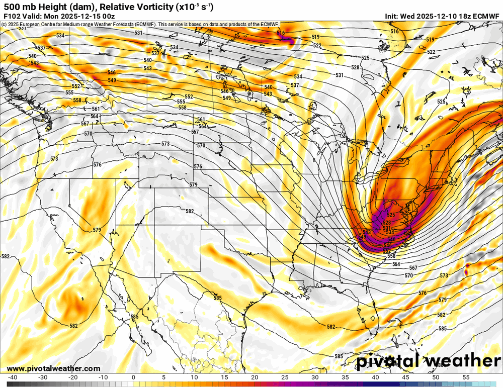
-
Great 30 for 30 on Stuart Scott. Trailblazer. Teared up a bit at the end.
-
0z CMC... *chef's kiss*

-
If the 12z suite tomorrow is good, then we should probably create a thread. The question is, who will create that thread?
-
Looks blizzardy at Canaan.
-
December 2025 regional war/obs/disco thread
TauntonBlizzard2013 replied to Torch Tiger's topic in New England
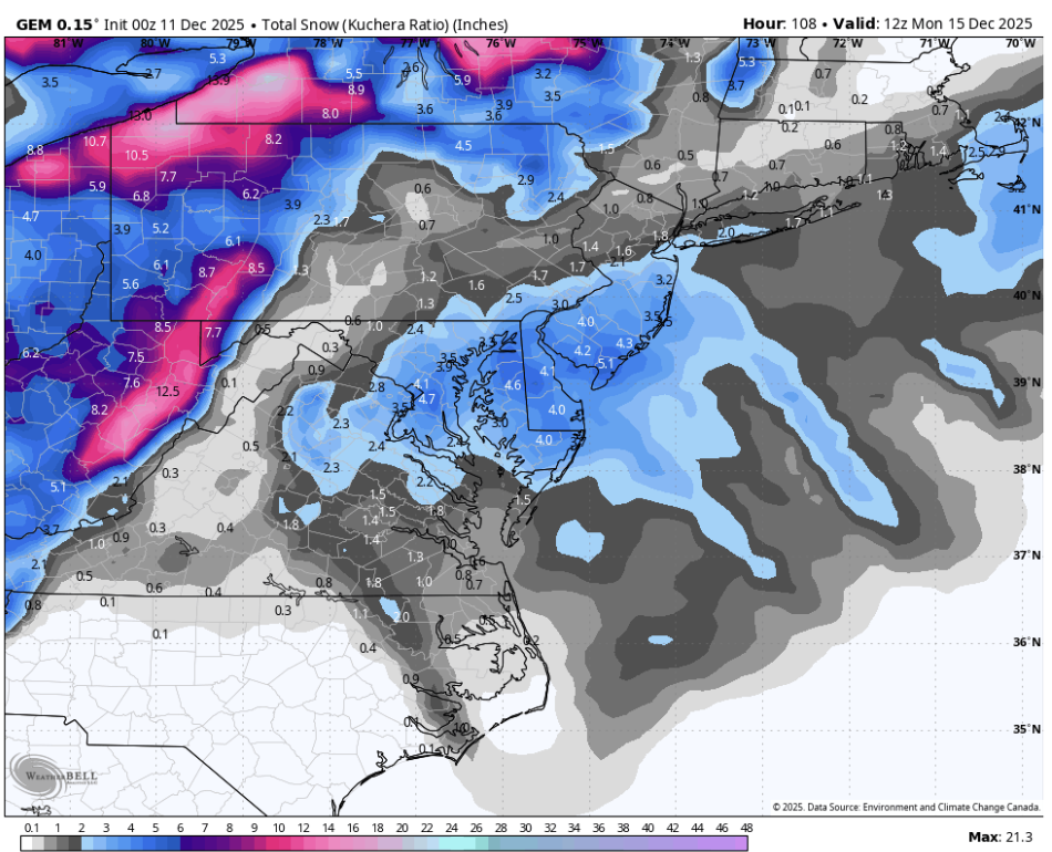
CMC went from a solid 3-5” snowfall across much of SNE at 12z to flurries outside the cape at 00z -
CMC at least came down south.
-
December 2025 regional war/obs/disco thread
TauntonBlizzard2013 replied to Torch Tiger's topic in New England
Canadian back to a scraper. Big step back from 12z. Im afraid we are moving towards a consensus. Gfs improved, and the models that were pretty good are moving towards the gfs and meeting in the middle, which amours to very little snow -
CMC pretty heavy band of snow in DC... probably an inch an hour?
-
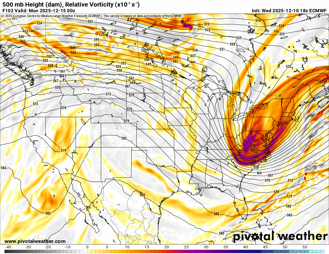
I was speculating where I think this is heading, not summarizing what all models are showing. I hope some of the wetter AI model solutions are right. But even they are relatively dry outside of southeastern areas. And they haven't shown a clear positive trend either. The trof is positively tilted and the PV is pretty far east. That's not a great height field orientation to work with... especially as we approach the short range.
-

Minor snow possible sunday 12/14/25
MJO812 replied to WeatherGeek2025's topic in New York City Metro
This looks like a 1-3 inch snowfall. -
RGEM looked pretty darn good so not surprised since they are essentially the same. GFS, ICON, RGEM all good for DC, at least. Ways to go but pretty good 00z despite how quiet it is in here
-
CMC Looks pretty nice
-

December 2025 regional war/obs/disco thread
weathafella replied to Torch Tiger's topic in New England
Ignoring all the AI models? -
Think we're getting close to some goalposts here or could this still improve some?
-
I don't think the 0z NAM is much better aloft, if at all, than 18z. The RGEM is a little worse. The GFS and ICON are a little better. Kind of a wash so far for 0z. I think this is heading towards a scraper or light event unless we see clear positive trends very soon.
-
Based on recent runs it appears there will be a pretty narrow zone with strong lift as modeled. Not the best outcome for the mental health of our subforum lol.
-

12/12: The little Friday clipper that could? Or won't.
bncho replied to dailylurker's topic in Mid Atlantic
With RIC at 6", they could realistically get 1-2" on Friday and 2-4" on Sunday, and then they've overachieved climo. lol -
Minor snow possible sunday 12/14/25
Franklin0529 replied to WeatherGeek2025's topic in New York City Metro
Cautiously optimistic. See what it looks like Friday -
That would do the entire eastern side of Vermont some good.
-
12/12: The little Friday clipper that could? Or won't.
notvirga! replied to dailylurker's topic in Mid Atlantic
If everything goes wrong for northern areas this weekend, central Virginia could conceivably have 15” of snow on Dec 14 -

December 2025 regional war/obs/disco thread
WinterWolf replied to Torch Tiger's topic in New England
Looks like the machines are gonna win this. GFS looks to be caving.