All Activity
- Past hour
-
What’s the point? A large population cannot even comprehend probabilities at their most simple application. Weather based probabilities already introduce a different dimension where product/forecast type and area coverage muddy how one would interpret the chance that x outcome happens specifically at their location. Ask a person what a 60% probability of an event happening within 25 miles of them means. Not a damn clue. This added level of complexity, then, cannot be for the benefit of the public. Suppose it’s a more hyper specific mode of grading forecasts internally?
-

Possible coastal storm centered on Feb 1 2026.
ineedsnow replied to Typhoon Tip's topic in New England
.thumb.png.5c9e54280c606d7cba79b915bc7a3405.png)
-

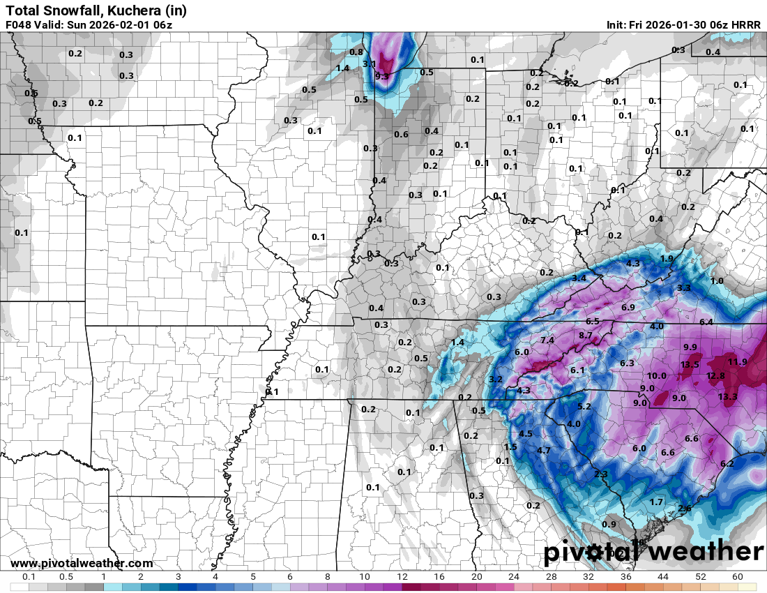
The “I bring the mojo” Jan 30-Feb 1 potential winter storm
JoshM replied to lilj4425's topic in Southeastern States
That dry slot is beyond brutal -
Good ole fashion NAMing! Area wide beat down. LP moves NE giving us a miller a type track.
-

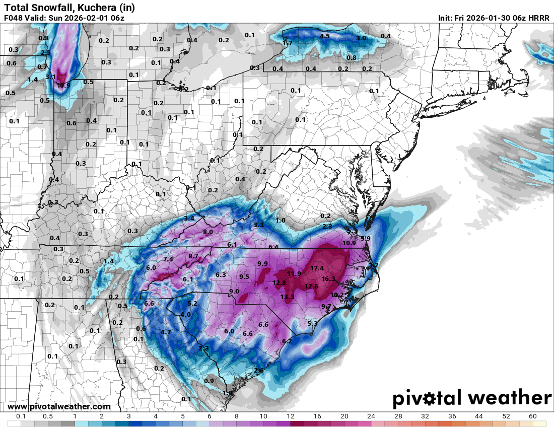
The “I bring the mojo” Jan 30-Feb 1 potential winter storm
timnc910 replied to lilj4425's topic in Southeastern States
3k NAM 6z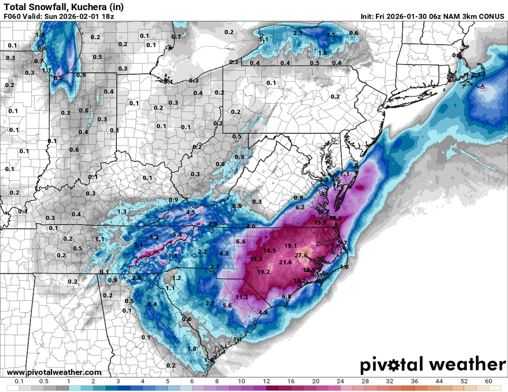
-
Richmond Metro/Hampton Roads Area Discussion
Siberian-Snowcover-Myth replied to RIC Airport's topic in Mid Atlantic
I believe RIC just got NAM’d….. could it be a trend?? -
Possible coastal storm centered on Feb 1 2026.
ineedsnow replied to Typhoon Tip's topic in New England
I thought this was going to be that 6z NAM run that brings everyone back in.. looked much better. Gets eastern areas with a bit and cape gets crushed -
The “I bring the mojo” Jan 30-Feb 1 potential winter storm
JoshM replied to lilj4425's topic in Southeastern States
Don't look at the 6z 3k NAM, it's < .10" -
My takeaway is NAM is leaning 2-4, 3k NAM is about 3, HRRR is 4-7, for Knox as a baseline for central valley, adjusting the gradient west to east. Edit: So basically inline with what MRX is forecasting. Almost at radar and HRRR watching phase.
-
Poor Hamilton County…. All alone without a WWA .
-
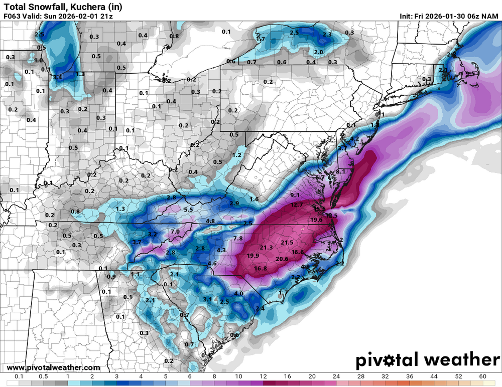
6z Nam

-

The “I bring the mojo” Jan 30-Feb 1 potential winter storm
ncforecaster89 replied to lilj4425's topic in Southeastern States
My previous post is gone, so I took the time to provide a new update: https://x.com/tbrite89/status/2017152042779689147 -

The “I bring the mojo” Jan 30-Feb 1 potential winter storm
lilj4425 replied to lilj4425's topic in Southeastern States

-
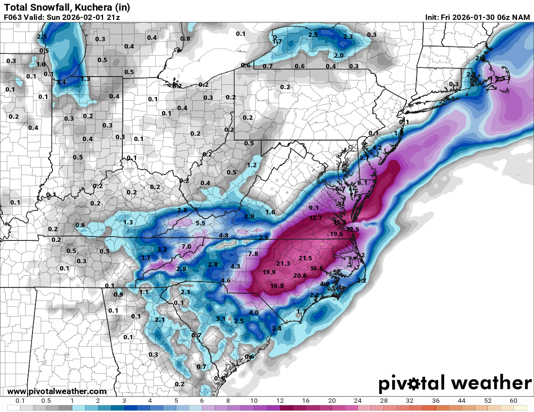
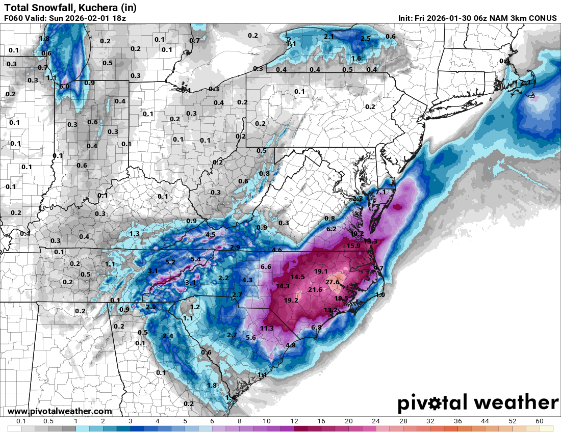
But top is nam 06 and bottom is nam 3k 06 see the difference
.thumb.png.2a456ad71fc0be9e1e65b34ec040ac72.png)
.thumb.png.6190443fd6a5ab54679632ca3af58b51.png)
-
It was early in model run thats why I edited my post
-
So if the model says 3 or 4 we double that possibly right since its a dry snow?
-
Not seeing that, what do you mean?
-
Hrr 06

-
Nam 06 only hitting knox north Edit looks better on 3k
-

Winter cancelled/uncancelled banter 25/26
Santa Claus replied to Rjay's topic in New York City Metro
-

The “I bring the mojo” Jan 30-Feb 1 potential winter storm
senc30 replied to lilj4425's topic in Southeastern States
So far, every model is saying 7"+ for me except the Euro. It is saying 3". Will be interesting to see exactly what happens. At least for my area, it's on an island by itself. -
- 568 replies
-
- 1
-

-
- extreme cold
- snow
- (and 1 more)
-
The “I bring the mojo” Jan 30-Feb 1 potential winter storm
timnc910 replied to lilj4425's topic in Southeastern States
06z HRRR and its still snowing in ENC
-

2025-2026 Fall/Winter Mountain Thread
ncjoaquin replied to Buckethead's topic in Southeastern States
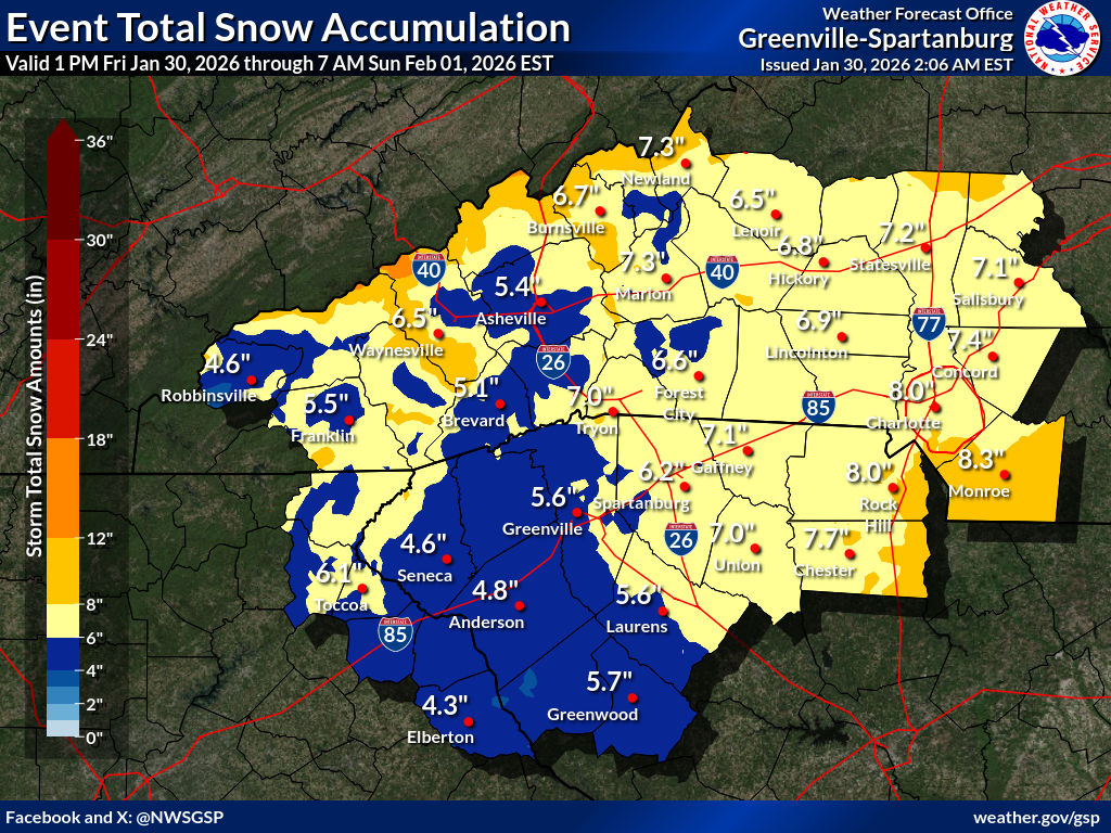
Below is for all mountain counties. GSP has upped it again. My current temp is 16.2. It has been a long time since I have been in the teens the morning of a snow storm. WINTER STORM WARNING REMAINS IN EFFECT FROM 4 PM THIS AFTERNOON TO 7 AM EST SUNDAY... * WHAT...Heavy snow expected. Total snow accumulations between 5 and 8 inches. Winds gusting as high as 50 mph. * WHERE...The mountains of North Carolina. * WHEN...From 4 PM this afternoon to 7 AM EST Sunday. -
I guess it makes sense to a weather weenie but this is way too much for the general public that still don’t even know the difference between a watch and warning.

.png.cb4670823fd8d40a34bd25293c17abe4.png)


.png.fa791c28b2952ea2f64fed882fa18295.png)
.png.adf831ef692a6ea484c0c48477178be9.png)