All Activity
- Past hour
-
There were some early signs that the ridge in the East was becoming much stronger back in December 2015. It was the first 50° December around NYC Metro which was a 13.3° even against the warmer climate normals. It backed off and we had the great January into early February. The 2016-2017 winter continued the strong ridging but the storm track was still in colder mode since 09-10. February 2018 had what Ryan called that bananas record 500 mb height with the first 80° warmth in February around NYC Metro. 18-19 continued the ridge in the Northeast but the storm track shifted warmer through the Great Lakes. So we began the current 7 year stretch of record low snowfall. 20-21 briefly had more of a benchmark track especially near the start of February. But the record Binghampton 40” snowstorm in December featured the -AO linking up with the ridge east of New England forcing the storm track too far west for NYC to Boston to get the heaviest totals. December 2021 had the record ridging from the Southern Plains to the East with the record +13 at DFW. Brief January return to Benchmark storm tracks followed by a milder February. January 2022 was the last time many areas around NYC Metro had a cold and snowy winter month. 2022-2023 and 2023-2024 continued the very strong ridge near the Northeast. The only month last winter that the ridge in the East was suppressed was January. But since we were in a La Niña pattern, the Northern Stream of the Pacific Jet remained too strong. So the much weaker STJ was easily suppressed and the Gulf Coast got the historic snows. My guess is if it was a strong enough El Niño instead, perhaps the STJ could have been juiced enough to force the storm track further north into the Mid-Atlantic and Southern New England. But yeah like in the post below, we continue to set new 500mb records throughout most seasons of the year.
-
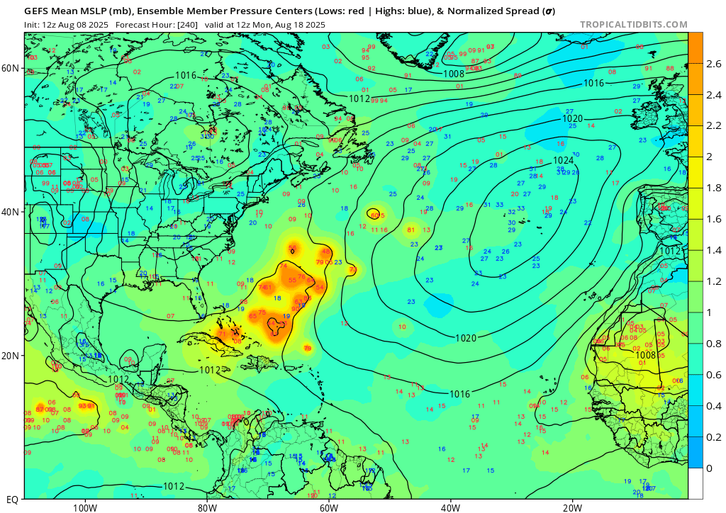
12z GEFS today still has the cluster in the atlantic at about 240 hours. only a couple members head west for the gulf

-
Please happen
-

TROPICAL WAVE LOCATED IN CHAD, AFRICA (NOT 96L)
TampaMan replied to BarryStantonGBP's topic in Tropical Headquarters
That makes me a feel a tad better, guess I'll know more in 5 days right before I leave for the trip. -
Maybe NOLA.
-
Anything but the Gulf. Unless it's Tampa or Houston, I'm all set with a 930 cane making landfall over a bayou.
-

TROPICAL WAVE LOCATED IN CHAD, AFRICA (NOT 96L)
GaWx replied to BarryStantonGBP's topic in Tropical Headquarters
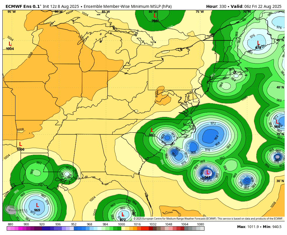
12Z Euro ensemble: many potential scenarios regarding the CONUS as would be expected this far out with many well offshore the E coast, some threatening the E coast, and 4 in/near the Gulf:
-
90 to 96, Mon-Wed using a straight up blend of the operational Euro and GFS
-
Something to keep an eye out. Certainly getting dry out there again like last summer. European ensemble mean says next 2 weeks could average 6-8F above normal locally.
-
That gives me some sort of relief I guess. Hoping whatever forms shoots up the East coast into the Atlantic. Is that more likely to happen instead of a direct hit? Seems like the rest of the storms between now and then are making that curve. (I don’t know much about the tropics so please forgive my ignorance).
-
yeah, entertaining fo' sho' but still, never seen a hurricane do an EC run thru a ridge and no steering field actually conducting it to do so in the first place. I feel that's beta drift in the model. If push came to shove I'd be forced to bet that a heat wave pattern from the OV-NE region sets the table for a Cane to do a Gulf o/mex entrance
-
either that or development will consistently shift sw, end up a GOM cruiser
-
TROPICAL WAVE LOCATED IN CHAD, AFRICA (NOT 96L)
TampaMan replied to BarryStantonGBP's topic in Tropical Headquarters
You’re absolutely right, we could ask for a delay. I’m going to put aside the house topic for now, because that’s doable really at any time. I should’ve clarified. We haven’t picked a house yet, we are going down to choose from 3 options we like. Down to our final three, so that can be put on pause. I’m mainly concerned about my PTO because I’ve had this week circled for 6 months at this point. It’s more so a vacation as well as house hunting. The neighborhood we’re looking at his multiple houses for sale and it’s a safe distance from the coast and at a higher elevation. I know it’s a risk you run living in Florida regardless. I’m hopeful for the sake of my vacation & sanity that it does not happen and even more so hopeful for the residents of FL. Edit: not 6 weeks, 6 months. -
it's like possible 100 F for 2 straight days followed by that yeeeeah
-
Likely standard Euro too. Don’t need to know the nuances—it’s impossible at this range—just that something is there.
-
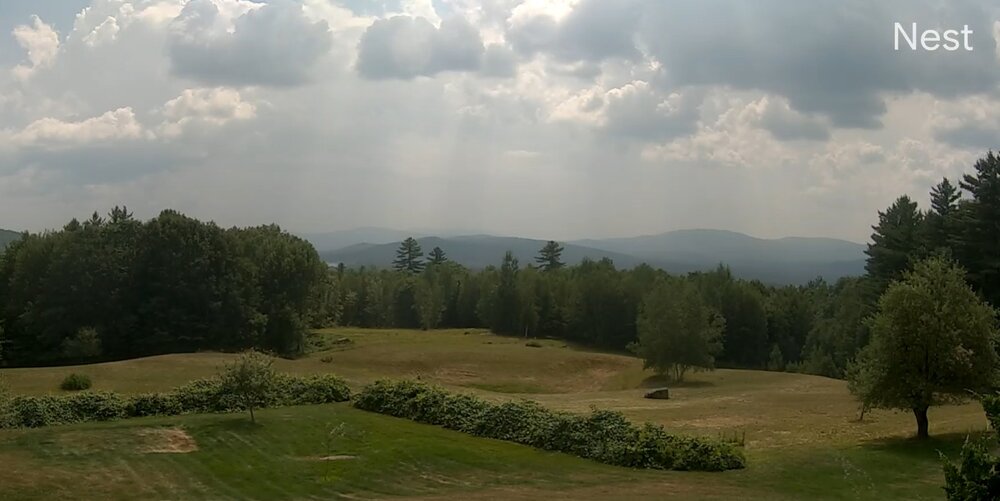
Still under 80 at CHO. The filtered sun is really holding temps down
-
6-10" of rain on the euro and 50-75+mph gusts depending on where you are. That would be fun. Of course this will track 300 miles east of here, but always fun to see.
-
Ray and I began noticing the atmospheric teleconnector correlation stressing over the last 10 years actually. It's an interesting aspect. I haven't dug into the matter at the granularity of that, but have noticed it and what you're saying isn't far off from what Ray and I have discussed in the past. From what I'm anecdotally observing ... it's not so much that a -EPOs or +PNAs ...-NAOs don't correlate. It's more about the lack of resonance feed-backs locking in patterns long enough to give the correlations a time to manifest. The ephemeral atmosphere syndrome ... they abandon the storms ... cold and hot looks. That heat wave near the end of June was clipped for length by higher frequency for example.
-
Same, tell Lisa I said hi.
-
Vis is better but still lots of smoke. I can see the sunrays from the Cu. We had a brief popup shower just west of air but otherwise dry, dry, dry. (Tell Lisa I said hi)
-
Violence on the euro
-
It will be another week before you should even begin to worry about what the models are showing...
-
TROPICAL WAVE LOCATED IN CHAD, AFRICA (NOT 96L)
GaWx replied to BarryStantonGBP's topic in Tropical Headquarters
If I were in your position, I’d be asking for a delay of this closing til after the potential threat from this is past. When do you need to ask for a delay by? Wouldn’t it be easier to be granted a delay if you ask sooner? Even though still only a small chance, what if this ends up hitting FL hard just after you close? I’d prefer that uncertainty to be past considering how big an investment this is. But that’s just me. -
My grandparents had a house in Long Valley, NJ which had a 3/4-acre lawn that we would mow. Each time we'd discover (usually painfully) 2-3 yellowjacket nests. My long-passed dad would not have followed the above - at about 4 AM he'd pour a half cup of gas into the entry hole and follow it with a match. One large nest had so much underground wasp-paper infrastructure that there was a bushel basket-sized hole after the burnout.
- Today
-
This dry air has bucked the trend of high minima so far. Highs are running +0.3 while lows are -5.4.