All Activity
- Past hour
-
Here's my winter outlook. (more of the same...)
-
My outlook. May do Edition 2 if things change in November. Or maybe not.
-
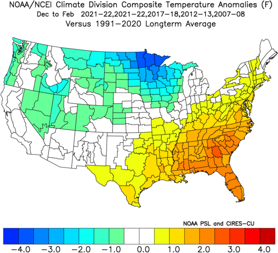
Not a whole lot has changed this month, so I decided to go ahead and issue my outlook for this winter. I'll keep it brief and simple: Overall winter feel: Meh, but not full-on blowtorch. Cool ENSO/weak basin-wide Nina coupled with -QBO Strong -PDO trying to turn the corner but not quite getting there -IOD bracketing MJO activity to phases 3-7 with limited 8-1-2 activity More weak troughing east of Japan pushing N. Pac High east into GOA (this helps us) Mostly -PNA, but with some +PNA episodes with plenty of Canadian cold air to tap into Weakly +NAO on the means with at least 2 or 3 bonafide -AO/-NAO blocking episodes Snowfall guess: 9-11" for the forum, maybe a few inches more for CAPE and northward of him Predicted mean DJF NH Pattern based on listed analogs (2021-22 weighted twice): SST changes last 15 days: Extrapolating cool SST/troughing east of Japan while warm blob pushes to the east. Cool area in GOA probably will not last. Atlantic pattern seems neutral towards NAO bias, but increased risk of SE ridge linkage with -NAO. Temp and Precip DJF Maps: Warmer and drier across the SE. Mild East Coast, but not torchy, plenty of cold air to tap into, but timing and SE ridge linkage will be an issue to contend with at times. Rockies, Upper MW, Great Lakes, and non-coastal SNE and all of NNE are poised to have a great winter.
-
Third cat 5 of the season. Absolutely insane.
-
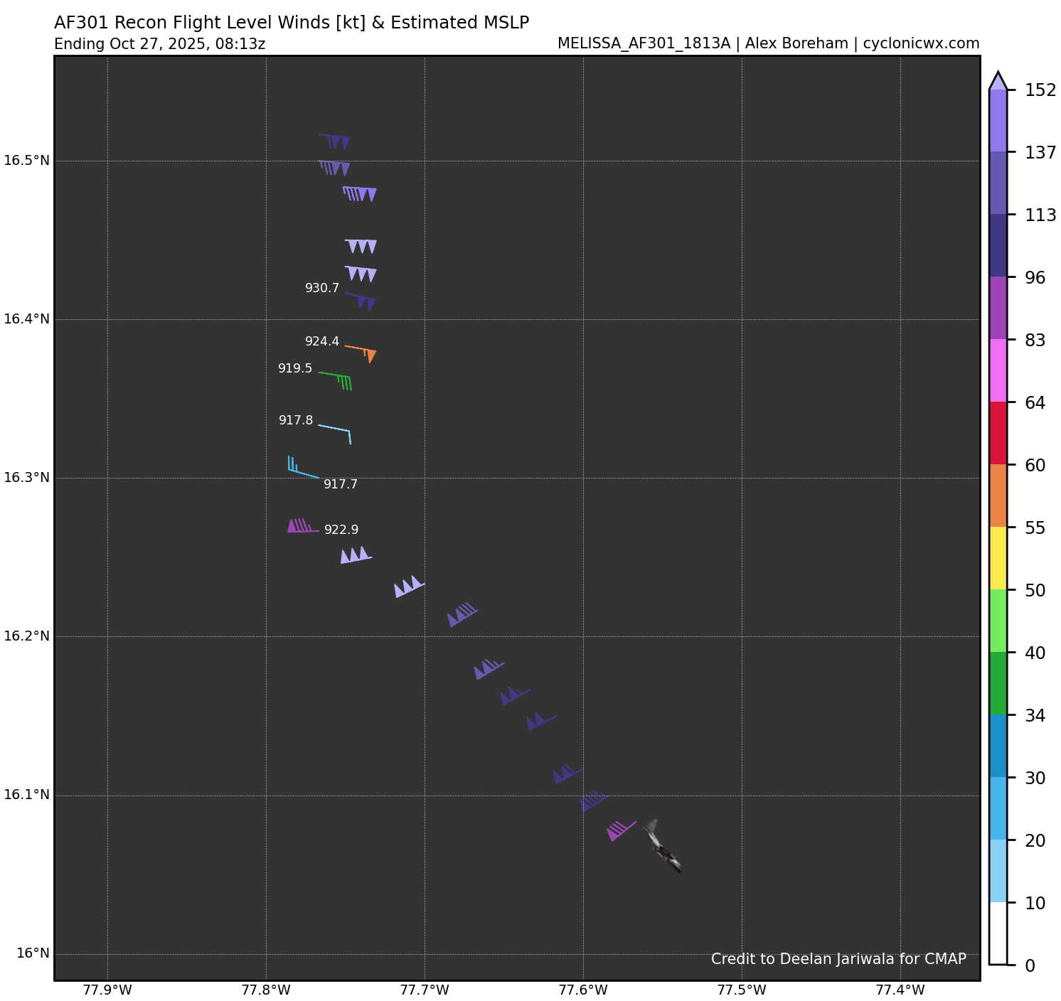
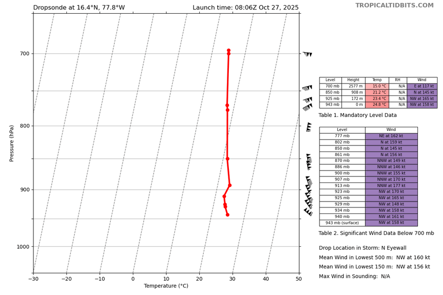
5:00 AM EDT Mon Oct 27 Location: 16.4°N 77.8°W Moving: W at 3 mph Min pressure: 917 mb Max sustained: 160 mph .
-
5:00 AM EDT Mon Oct 27 Location: 16.4°N 77.8°W Moving: W at 3 mph Min pressure: 917 mb Max sustained: 160 mph .
-

Spooky Season (October Disco Thread)
Damage In Tolland replied to Prismshine Productions's topic in New England
The screamer is Thursday / Thursday night with dry slot Friday. Helloween is saved for Scooter -
those winds were not measured at the surface..
-

Spooky Season (October Disco Thread)
ineedsnow replied to Prismshine Productions's topic in New England
Melissa a cat 5 now.. what a beast -
Officially a Cat 5
-
Recon measured 158kts in the north eyewall at the surface. This equates to 180-185mph range for surface winds.
-

Spooky Season (October Disco Thread)
Modfan2 replied to Prismshine Productions's topic in New England
Down to 29F so far here this morning, pretty chilly. -
Since we are almost into November, I figured I would go ahead and start this new thread for the 2025-2026 winter season. Current ENSO indicates a weak La Nina to Neutral type winter. Snow and cold forecasts could go either way. Feel free to share your thoughts and forecasts for this upcoming winter.
- Today
-
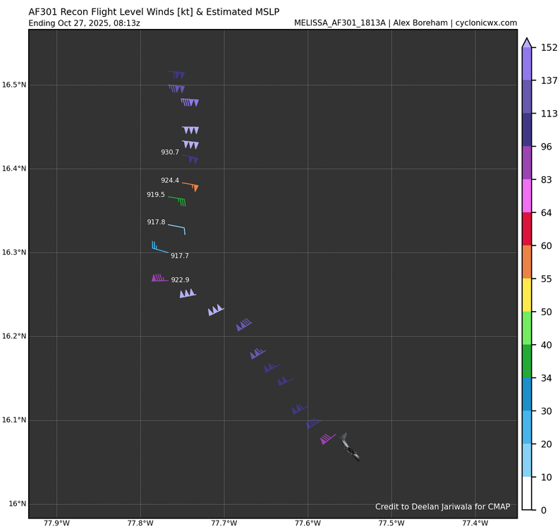
917mb in N/NE quad. Along with the 140kts they measured earlier in the NE quad, Melissa will now be upgraded to a Category 5. Either we get a special advisory or they wait for 5am.
-
Looks like we are around 30 hours from landfall give or take a few depending on timing of the trough influenced deep layer southerly flow. We should start to see northward motion begin by midday or noon'ish. Timing on this is critical for the eventual landfall point.
-
The view of a peaceful starry night, inside the maelstrom of Melissa.
-
Yeah recon shows no evidence of weakening. Probably the opposite at this hour. I mean, expect another 2-4mb drop on the next pass. The ERC will happen eventually, but it’s not right now.
-
Your assumption on ERC is wrong, point of my remark. The asymmetry is from friction and the trough. There’s also deep convection that fired in the east quadrant. Melissa is showing no signs of weakening. I mean, we literally have pressure falling and winds increasing on each recon pass right now.
-
The trough is also moving into influence which can begin to affect symmetry and convection on the periphery of the TC, including the outflow channela. Otherwise, Melissa's core is about as textbook as it gets for a powerful Atlantic Caribbean hurricane. Current appearance kind of reminds me of Matthew. I think it's more the latter, yeah you can see part of the outflow racing off to the northeast. As the whole storm turns it'll reorient, but if the coastal interaction happens before it can wrap the convection around more, I don't see how it isn't currently at around its peak strength, which is impressive enough.
-
Remarks Section - Remarks That Were Decoded... Maximum Flight Level Wind: 152kts (~ 174.9mph) which was observed 5 nautical miles to the N (358°) from the flight level center at 7:05:00Z Remarks Section - Additional Remarks... SAWTOOTH APPEARANCE AND FREQUENT LIGHTNING PRESENT ALONG NORTHERN EYEWALL
-
It's already at 160mph. It's some ask for it to rapidly intensity from there! Esp when it is looking less symmetrical.
-
The trough is also moving into influence which can begin to affect symmetry and convection on the periphery of the TC, including the outflow channels. Otherwise, Melissa's core is about as textbook as it gets for a powerful Atlantic Caribbean hurricane. Current appearance kind of reminds me of Matthew.
-
Also, asymmetry can happen in Category 5’s when they start to feel friction with the coast.
-
No, recon hunter data confirms no ERC is ongoing or imminent. What is happening to cause the asymmetry is deep convection firing. Melissa is undergoing another RI process. We just happen to have recon hunters inside the storm this time.
-
First appearance of any asymmetry in a while on ir. Deeper convection away from eyewall in ne quadrant. Imagining this is an ewr beginning? Hopefully it can't finish before becoming a slightly larger windfield version of the same beast we just saw.