All Activity
- Past hour
-
Very little support from the GEFs ensemble system wrt the operational run doing that with that big closed summer ending menace. The 00z had it, the 06z diametrically reversed and had big number heat implied ... 12z vacillated all the way back to the 00z run... so big yo-yooing that doesn't conform to the ensembles/telecon is highly suspect as the GFS being the Good For Shit model
-
Gfs is so broken.
-
GFS at the same time... LOL
-
2nd place temp behind 49 (1947). Top 5 cool wx here in TH with temps in the lower 50's. 55 in Brainerd was record low max.
-
Ended up with 1.43 total. It is incredibly humid for mid June
-
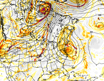
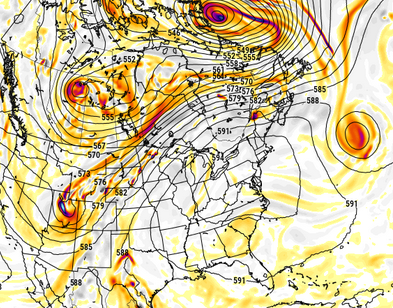
here it is out at hour 216 .... that's maximizing. The ridge construct is so rubust it's hard to image a single cloud in the sky open pure sear must be circumstantial underneath this synoptic structure. G-pot heights approaching 600 dm, 12 hours after this interval over NYC-BOS.
-
Canadian implies potential high heat on this 12z run - definitely moving in a hotter direction, as well. previous run vs this 12z centered on 180 hrs

-
I've also noticed the solar panels keep my roof cooler, so it's a win/win. I'm only at $295 credit on my latest bill, but that will probably increase by a few more hundred come September.
-
I used the existing wire from my former electric hot water tank. It happened to be the exact gauge I needed. Wiring isn't very difficult. You can youtube just about anything.
-
Last dry / warm and sunny weekend day was May 17th
-
Finally a good weekend next week in time for the solstice
-
53.6°, with misery mist. 0.16" in the gauge. Heat would be kicking in were it not for the fact I have it turned off.
-
4 weekends out of 15 summer weekends flushed down the drain The loss of money of the beach businesses losing 9 days so far has to be enormous
-
I’m down in Bedford for the weekend but it was raining in Stowe when we left this morning. Not much rain on the drive, just some mist at times. Looks about right for a Saturday.
-
There’s way too much taking model output and machine numbers verbatim. One look at that ridge and thicknesses from Thursday onward thru end of month shows high dews and steamy . Could be a day after a severe outbreak that dries a bit , but dews right back into 70’s after
-
The EPS is a warm look until very late in the period. It won’t be 95/75 every day, but there could be a few fairly oppressive days. This crap we have is done.
-
I guarantee you we wont get a day as cold as today in September.
-
61 degrees here at low noon =\
-
why are these models showing 70s on the south shore though?
-
Well stein disappeared
-
Yep
-
Moderate rain into CNJ with heavier rain in EPA
-
Take those dews up. Plenty of 70+ coming starting late next week.
-
well now September is becoming hotter than June lol about December, winter really starts after midmonth, early December still feels like fall.
-
With all due respect ... where are you seeing constraining factors on T or DP ? It isn't through conventional means, because from operational trends, to teleconnector/mass field correlations and back , the whole methodology has +2 ST DP and +1.5 SD T at this time, which in sensible terms is 91/73 type stuff ...roughly from D7 to 14 - but these time ranges are obviously negotiable. Course, we are talking still a week+ away. If you are constraining things based on seasonal trend to bone warm pattern and verIfy a low-balled result? okay. LOL


