All Activity
- Past hour
-

July 2025 Obs/Disco ... possible historic month for heat
kdxken replied to Typhoon Tip's topic in New England
I don't recall anyone saying cold. -

July 2025 Discussion-OBS - seasonable summer variability
LibertyBell replied to wdrag's topic in New York City Metro
It's wild that many of these coops are still around Chris! But the one at Mineola isn't any longer is it (the one that recorded 108 in July 2011?) It would be interesting to see what they would have recorded in that June 2025 extreme heatwave. -

July 2025 Obs/Disco ... possible historic month for heat
dendrite replied to Typhoon Tip's topic in New England
588dm mean over SNE d15. Is that supposed to be cold?
-

July 2025 Obs/Disco ... possible historic month for heat
Damage In Tolland replied to Typhoon Tip's topic in New England
June was top 5 -
July 2025 Discussion-OBS - seasonable summer variability
LibertyBell replied to wdrag's topic in New York City Metro
Thanks we're one off the lead for 100+ and two off the lead for 98+ I think 1983 was the only one at JFK that had two different heatwaves get to 100+, one was in July and the other one was in August. -

July 2025 Obs/Disco ... possible historic month for heat
Torch Tiger replied to Typhoon Tip's topic in New England
we are also farting out top 5's, you're making my point. :/ -
July 2025 Discussion-OBS - seasonable summer variability
LibertyBell replied to wdrag's topic in New York City Metro
JFK hit 100+ on all three of those days Don? I thought it was 2 while it was 3 at NYC? -
July 2025 Obs/Disco ... possible historic month for heat
Damage In Tolland replied to Typhoon Tip's topic in New England
They just don’t get it -
July 2025 Obs/Disco ... possible historic month for heat
dendrite replied to Typhoon Tip's topic in New England
I wouldn’t rule out top 5 yet. -
They're getting rich, hope this helps
-
July 2025 Obs/Disco ... possible historic month for heat
dendrite replied to Typhoon Tip's topic in New England
114 years ago today One of the hottest New England days on record…especially north of Pike All time records for VT and NH (ME was 6 days later) BOS 104 PWM 103 CON 102 ORH 102 (old site but only 100+ on record) -
Today will be the 13th 90 degree day here, and the 11th for MLI.
-
.thumb.png.4150b06c63a21f61052e47a612bf1818.png)
July 2025 Obs/Disco ... possible historic month for heat
HIPPYVALLEY replied to Typhoon Tip's topic in New England
It will be AN for sure but nobody in New England is breaking heat records with that EPS look. -

July 2025 Discussion-OBS - seasonable summer variability
SACRUS replied to wdrag's topic in New York City Metro
Under the ridge - warm-hot / humid and wet - EUro similar to the GFS/C -
July 2025 Discussion-OBS - seasonable summer variability
SACRUS replied to wdrag's topic in New York City Metro
JFK 100 degree season leaders: Year Rank Days >= 100 °F 2010 1 3 1966 1 3 2025 3 2 2011 3 2 1993 3 2 1983 3 2 1948 3 2 2013 8 1 1999 8 1 1972 8 1 1963 8 1 1957 8 1 JFK 98 Degree days leaders (i think i saw this asked a few pages ago, days ago) Year Rank Days >= 98 °F 2010 1 4 1983 1 4 1966 1 4 2011 4 3 1949 4 3 1948 4 3 2025 7 2 2019 7 2 2002 7 2 2001 7 2 1999 7 2 1993 7 2 1991 7 2 1978 7 2 1964 7 2 1963 7 2 1955 7 2 1952 7 2 -

July 2025 Obs/Disco ... possible historic month for heat
RUNNAWAYICEBERG replied to Typhoon Tip's topic in New England
We fart out AN months now, duh. The point still stands…it won’t be an all time hottest month or top 5er. -
July 2025 Discussion-OBS - seasonable summer variability
SACRUS replied to wdrag's topic in New York City Metro
Records: Highs: EWR: 105 (1949) NYC: 102 (1949) LGA: 100 (1949) JFK: 101 (2010) New Brnswck: 100 (1966) Lows: EWR: 58 (1945) NYC: 55 (1986) LGA: 57 (1940) JFK: 59 (2021) New Brnswck: 47 (1986) Historical: 1776: Thomas Jefferson paid for his first thermometer and signed the Declaration of Independence. According to his weather memorandum book, at 2 PM it was cloudy and 76 degrees. (David Ludlum) (Ref. WxDoctor) 1816: In Savannah, Georgia the temperature dropped into the 40's on July 4th. (p. 33 Washington Weather Book 2002 by Ambrose, Henry, Weiss) Chauncey Jerome of Plymouth, Conn. saw several men pitching quoits in the middle of the day with thick overcoats on, and the sun shining bright at the time. (Scientific American, "The Year without a Summer" p. 48) 1825 - A hurricane struck Long Island NY leveling trees and causing damage to ships. The early season hurricane, which originated around Cuba, caused major damage along the Atlantic coast from Charleston SC to New York City. Many were lost at sea. (David Ludlum) 1825: A severe storm of tropical origin swept up the Atlantic Coast during the first week of June 1825 with reports of significant damage from Florida to New York City. Shipping logs told of a disturbance at Santo Domingo on May 28th and Cuba on June 1st. Gales were reported at St. Augustine, Florida on the 2nd. The Norfolk and Portsmouth Herald reported "undiminished violence" from the gale force winds for 27 hours, ending on June 4th. The effect of the storm reached well inland. Washington had cold, heavy rain all day on the 4th with high winds laying the crops in the vicinity. The wind also tore up trees by the roots in front of the State House in Philadelphia. This storm impacted the New Jersey Coast and the Long Island area as well with high winds and a two-foot storm surge. A Columbian frigate was driven ashore as were many smaller boats. The largest loss of life occurred along the Long Island shore when a schooner capsized. The entire crew of seven was lost. 1860 - Iowa's Commanche Tornado , with wind speeds estimated in excess of 300 mph, was unquestionably one of the worst experienced by early settlers, with nearly a million dollars damage. (The Weather Channel) 1874: Tornadoes hit the Baltimore, MD/Washington, DC area, causing minor damage, but a major tornado hit Lewistown, PA, killing eight people. (Ref. Wilson Wx. History) 1876: Centennial Maximum temperature 95° in Washington, DC. (Ref. Washington Weather Records - KDCA) 1876: Severe thunderstorms hit the Midwest and a dam failed at Rock Dale, IA. The flood destroyed a railroad bridge and swept through the town. 42 people were killed. (Ref. Wilson Wx. History) 1877: A tornado of estimated F4 intensity touched down just west of Mt. Carmel, Illinois and moved east-northeast, devastating the town. 20 businesses and 100 homes were damaged or destroyed. At least 16 people and as many as 30 were killed, with 100 others injured. 1891: Sixteen horses were killed by hail, and many more had to be put to death due to injuries from a hailstorm at Rapid City, SD. (The Weather Channel) 1911: The northeastern U.S. experienced sweltering 100-degree heat. The temperature soared to 105 degrees at Vernon, VT and North Bridgton, ME, and to 106 degrees at Nashua, NH, to establish all-time records for those three states. North Bridgton, ME also had 105 °F on July 10, 2011. Afternoon highs of 104 at Boston, MA, 104 at Albany, NY, and 103 at Portland, ME, were all-time records for those three cities. Boston, MA recorded its highest temperature of 104 °F. (all time) (Ref. NOAA Boston Weather Events) (Ref. Lowest and Highest Temperatures for the 50 States) (The Weather Channel) 1919: Hottest 4th of July was 100° at Washington Weather Bureau Office. (Ref. Washington Weather Records) 1932: Washington, KS was struck by a huge F4 tornado. 5 people were killed. (Ref. Wilson Wx. History) 1956: A world record for the most rain in one minute was set at Unionville, MD with a downpour of 1.23 inches. (The Weather Channel) (The National Severe Storms Forecast Center) (Ref. For More Information) 1967: Canadian high pressure behind a strong cold front brought record chill to the northern Plains. Record lows for July included: Decorah, IA: 41°, Elkader, IA: 46°, and Genoa, WI: 46°. Other daily record lows included: Bismarck, ND: 36°, International Falls, MN: 36°, Fargo. ND: 37°, Waterloo, IA: 43°, Rockford, IL: 46 °F. (Ref. Wilson Wx. History) 1969: "The Ohio Fireworks Derecho" States that were affected, MI, OH, PA, WV Severe thunderstorms accompanied by wind gusts of 100 mph dumped heavy rains of 4 to 15 inches across parts of northern Ohio causing major flash flooding. 41 deaths, 359 injuries resulted and damage exceeded $66 million dollars. In southwest Lower Michigan, More than 60 people were injured, most of them from a tornado that hit Flat Rock in southern Wayne County. The tornado destroyed a tile factory, carrying sheet metal over a mile. Another tornado injured 11 people about four miles east of Jackson as it damaged a dozen mobile homes. (Ref. For More Information) 1972: Chilly Canadian high pressure brought record cold to parts of the northern Plains and Midwest. Jump River, WI dropped to 27° and Blair, WI fell to 36° setting a record for their coldest July temperature. Also, Jump River had the coldest temperature ever recorded in July for Wisconsin. (Ref. Additional Temperatures Listed On This Link) 1974: Memphis, Tenn.--Lightning struck three youths running across a playground; killed one, injured two. Waitwell, Tenn.--Lightning struck two youths who were playing in a wooded area; killed one, injured the other.(Ref. Lightning-The Underrated Killer.pdf) 1977: "The Independence Day Derecho of 1977" States that were affected --- ND, MN, WI, MI, OH A severe thunderstorm produced vicious downburst winds of up to 135 mph across parts of northern Wisconsin. Damage was extensive in Price, Sawyer, and Oneida Counties with a downburst damage path of 166 miles long and up to 17 miles wide. One person was killed and 35 were injured. Total damage was $24 million dollars. A widespread severe weather outbreak hit Lower Michigan with tornadoes and downbursts. Two people were injured and almost a million dollars damage was done. A tornado injured one person and destroyed two mobile homes and one barn near Maple Ridge in Arenac County. Another person was inured by a tornado at Otisville in Genesee County as four mobile homes were destroyed there. (Ref. For More Information) 1978: A squall line developed in east central South Dakota during the late afternoon. Winds of 90 mph leveled a number of farm buildings in southern Beadle County although no one was injured. A tornado touched down in southern Minnehaha and northern Lincoln counties although the tornado did little damage. All told the squall lines' high winds and numerous tornadoes did $7.5 million dollars in damage. A violent F4 tornado moved slowly through Grant County in North Dakota. The tornado tracked 28 miles in about one hour. Five people were killed in the town of Elgin. (Ref. Wilson Wx. History) 1980: Extremely humid weather was found across central Illinois. Springfield reported 11 consecutive hours with a dew point temperature of 80° or higher before a line of severe thunderstorms brought cooler air to the region. (Ref. Wilson Wx. History) 1982 - A four day storm began over New England which produced up to 14 inches of rain in southern Connecticut breaching twenty-three dams and breaking two others. Damage was estimated at more than 276 million dollars. (David Ludlum) 1987 - Early morning thunderstorms in south Texas produced 6.5 inches of rain at Hockheim, and five inches at Hallettsville, in just a few hours. Afternoon thunderstorms in Virginia deluged northern Halifax County with 5.5 inches of rain in two hours. Thunderstorms produced wind gusts to 76 mph at Dusty WA, and wind gusts to 88 mph at Swanquarter NC. (The National Weather Summary) (Storm Data) 1988 - A dozen cities in the eastern U.S. reported record low temp- eratures for the date, including Atlantic City NJ with a reading of 40 degrees. Fifteen cities in the north central U.S. reported record high temperatures for the date, including Glasgow MT and Havre MT with readings of 102 degrees. (The National Weather Summary) 1989 - Thunderstorms produced severe weather from the Southern Plains Region and the Lower Mississippi Valley to the Southern Atlantic Coast Region during the day and into the night. Just four tornadoes were reported, but there were 87 reports of large hail and damaging winds. (The National Weather Summary) (Storm Data) 1994: Tropical Storm Alberto formed in the southeast Gulf of Mexico on July 1st and moved north at 10 mph. The center crossed the panhandle near Destin at 0900z on July 3rd. At landfall the minimum central pressure was 993 millibars (29.32 inches of mercury) with maximum sustained winds of 63 mph and gusts unofficially estimated at 86 mph. Alberto weakened to a depression before moving into southeast Alabama the evening of July 3rd, then meandered around east central Alabama and west central Georgia for 72 hours dropping rains that locally exceeded 20 inches in southwest Georgia. River flooding in Georgia and Alabama spread into the Florida panhandle on July 5th, and along with six to 14 inches of additional rain from the remnants of Alberto, caused extensive flooding. Flood crests exceed 100-year events on the Apalachicola and Chipola Rivers. Damage to buildings, roads, water systems and other public property was estimated at $40 million dollars. Insured losses to buildings and vehicles were estimated at $15 million dollars. Agricultural losses were estimated at $25 million dollars. (Ref. Wilson Wx. History) 1995: 19 members of a single family were struck by a lightning bolt during a Fourth of July fireworks display in Visalia, NC. A bolt of lightning struck a construction crane, crossed wet ground and surged through a fence, affecting 70 people altogether. Fortunately, no one was killed or seriously injured. It is believed to be the most people ever struck by a single bolt of lightning. (Ref. Wilson Wx. History) 2001: A severe hailstorm struck Scottsbluff, NE producing hail up to 3 inches in diameter. About 12 people were injured with damage estimated at $50 million dollars. (Ref. Wilson Wx. History) -

July 2025 Discussion-OBS - seasonable summer variability
bluewave replied to wdrag's topic in New York City Metro
Maybe the ASOS back in 1966 wasn’t so close to the water at LGA. But not sure. The current location is right on the bay near the NW corner of the airport. Data for July 3, 1966 through July 3, 1966 Click column heading to sort ascending, click again to sort descending. NY LAGUARDIA AIRPORT WBAN 107 NJ NEWARK LIBERTY INTL AP WBAN 105 NY NEW YORK AVE V BROOKLYN COOP 105 NY PORT JERVIS COOP 104 NY NEW YORK LAUREL HILL COOP 104 NY JFK INTERNATIONAL AIRPORT WBAN 104 NY ISLIP-LI MACARTHUR AP WBAN 104 NJ ELIZABETH COOP 103 NY NY CITY CENTRAL PARK WBAN 103 NY WEST POINT COOP 103 NY MINEOLA COOP 103 NJ PLAINFIELD COOP 102 NJ JERSEY CITY COOP 102 NY NEW YORK FLOYD BENNETT FIELD WBAN 102 NJ LITTLE FALLS COOP 102 NY SCARSDALE COOP 102 NY BEDFORD HILLS COOP 102 NY NY WESTERLEIGH STAT IS COOP 101 NJ PATERSON COOP 101 NY DOBBS FERRY-ARDSLEY COOP 101 NY STEWART FIELD WBAN 101 NY HEMPSTEAD GARDEN CITY COOP 101 CT NORWALK GAS PLANT COOP 101 CT DANBURY COOP 101 -

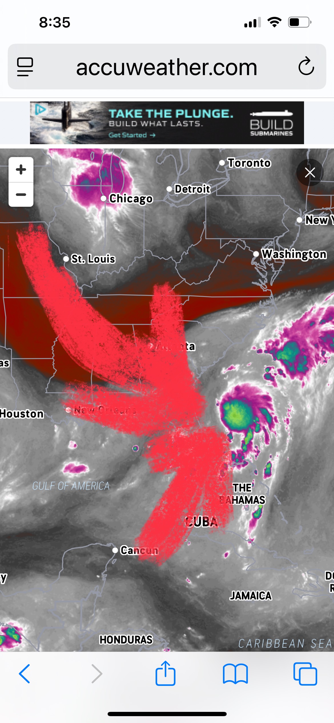
Invest 92L--50% Two Day & 60% Seven Day Odds
Kevin Reilly replied to WxWatcher007's topic in Tropical Headquarters
Good outflow aloft. Looks like depression to me or even a 40-45 mph Tropical Storm Chantal. Small Upper level low just southeast of Atlanta Georgia and dry air punching in from the northwest should limit development but also should tug what could become Chantal towards the southeast South and North Carolina coastline before gradually moving back off to the northeast. Another interesting area well to the east of the Bahamas. Things waking up a bit out there.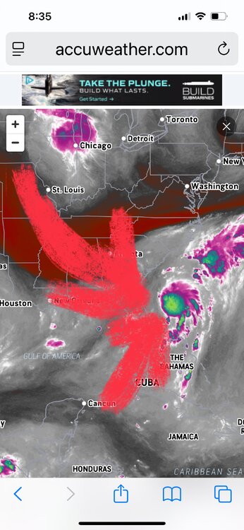
-

July 2025 Discussion-OBS - seasonable summer variability
donsutherland1 replied to wdrag's topic in New York City Metro
Yes. There was also August 26-28, 1948. -
Was this adjusted later to 90 at JFK? We hit 92 here but I thought JFK fell just short at 89 Tony?
-
July 2025 Discussion-OBS - seasonable summer variability
LibertyBell replied to wdrag's topic in New York City Metro
It hit 92 here -- I guess JFK gets the sea breeze before we do. What I want to know is how did Bridgeport hit 90, aren't they on a peninsula that extends into Long Island Sound? -
July 2025 Discussion-OBS - seasonable summer variability
LibertyBell replied to wdrag's topic in New York City Metro
we had a great triple rainbow!!! -
July 2025 Discussion-OBS - seasonable summer variability
LibertyBell replied to wdrag's topic in New York City Metro
What confuses me about July 1966 is that usually JFK and LGA need the diametrically opposite wind directions to record their hottest temperatures, how did they both record their all time records on the same day? And Central Park did not? -
July 2025 Discussion-OBS - seasonable summer variability
SACRUS replied to wdrag's topic in New York City Metro
69 / 60 - gorgeous day on tap and a nice stretch through at least Sunday of dry weather. 80s today sunny clear - great so cal style beach day - bbq - outside , pool, and fireworks on the bay or beach. Saturday looks like a copy a shade warmer get the hot spots to 90. Sunday hotter with more widespread 90s mainly inland as onshore/seabreeze kicks in. Mon - Wed - warm - hot / humid but storm chances each day return with onshore component keeping the heat focuses west in NJ but could get to 90 into the boroughs. Beyond beyond overall warm to hot / humid and wetter with ridge building into the east with stronger heat by the 17th. 7/4 - 7/6 : Dry / clear (80s 4th, 80s - 90s 5th/6th hotter) 7/7 - 7/10: Warm, - hot / wetter 7/11 - 7/16 : overall warm - hot / humid / wetter 7./17 - beyond : hotter